
Objectives of the service
The service aimed to address key challenges faced by railway infrastructure managers, such as monitoring and maintaining railway tracks to prevent misalignments, structural failures, and costly disruptions in train operations. Traditional monitoring methods often require manual intervention, are prone to interference with railway operations, and may not provide the necessary precision to detect small but critical displacements.
This project introduced an innovative solution based on low-cost Global Navigation Satellite System (GNSS) technology to provide continuous, automatic, and high-precision monitoring of railway track displacements. The service covers the collection of GNSS data through miniaturized sensors attached directly to the rails, the transmission of data to a cloud-based processing center, and the computation of both relative and absolute displacements. Results are delivered to users through a web-based dashboard, providing real-time insights.
The project also focused on developing an end-to-end service that includes hardware deployment, remote monitoring, and technical support. By offering continuous, non-invasive monitoring, the solution enables railway operators to proactively manage maintenance, optimize operations, and improve the safety and reliability of their infrastructure.
Users and their needs
The service primarily targets railway infrastructure owners and operators. These users are responsible for managing extensive railway networks and ensuring the safety and reliability of rail transport.
User needs:
-
Continuous monitoring: Real-time, automatic monitoring of railway track displacements without manual intervention.
-
Early detection of structural issues: Identify small, critical displacements to prevent track misalignments, deformations, or structural failures.
-
Minimizing operational disruptions: Non-invasive monitoring that avoids interruptions in train services during installation and operation.
-
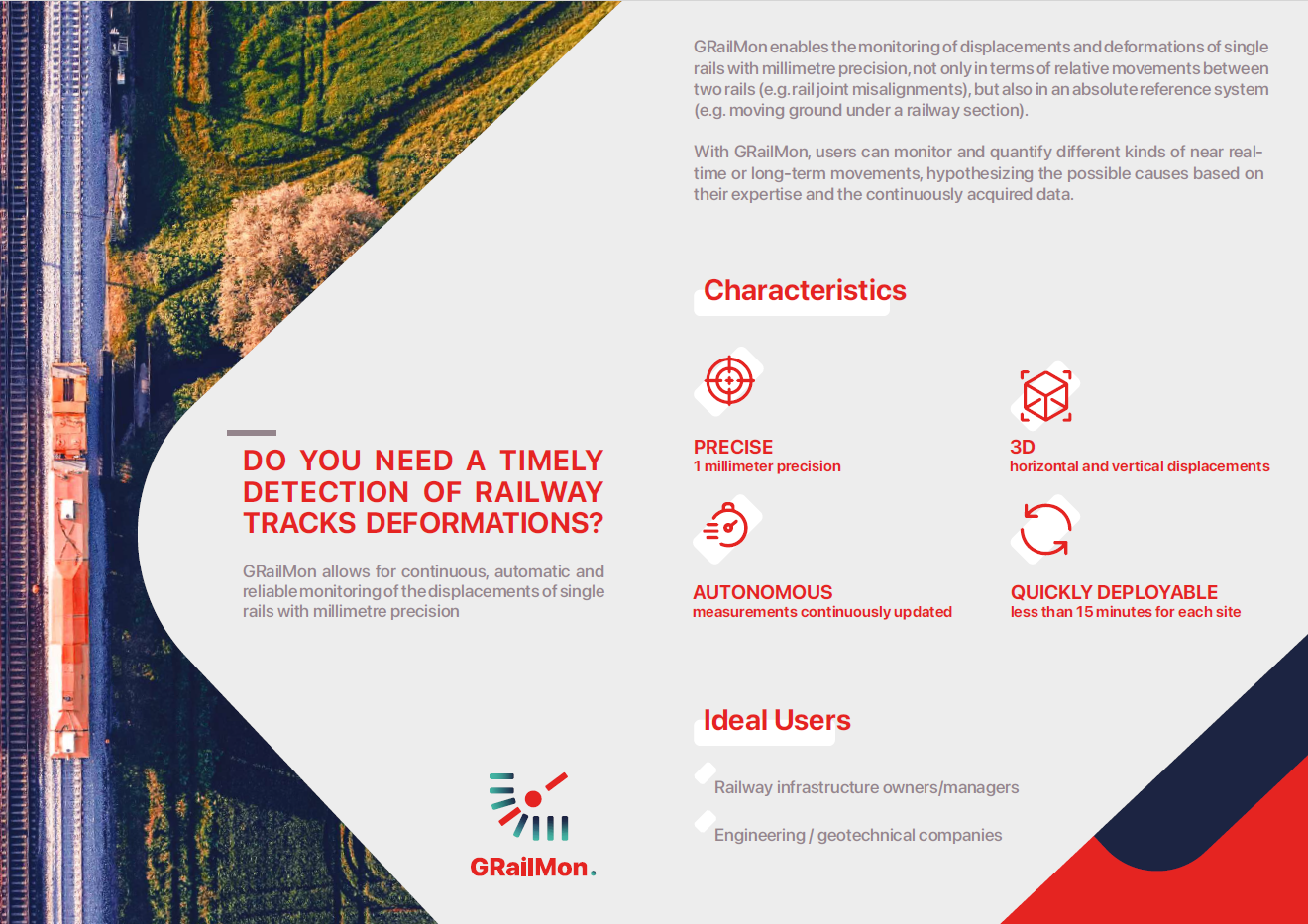
High precision: Accurate measurement of both horizontal and vertical displacements with millimeter precision.
-
Remote management: The ability to manage the monitoring system remotely, reducing the need for on-site personnel.
Challenges for the project:
-
Ensuring that the GNSS-based system provides the required precision in a variety of environmental conditions, including urban and rural settings.
-
Developing hardware that is robust enough to handle the harsh conditions around railway tracks, including vibrations and adverse weather.
-
Providing a seamless, user-friendly platform for delivering data and alerts to the railway operators
Service/ system concept
The service provides users with real-time data on the displacements and movements of railway tracks, delivering both horizontal and vertical measurements with millimeter precision. Users receive detailed information about the relative and absolute positions of critical points on the tracks, allowing them to monitor potential misalignments or deformations. Alerts are automatically generated if movements exceed predefined thresholds, helping users take timely action to prevent structural failures.
The system works through miniaturized GNSS (Global Navigation Satellite System) antennas that are securely attached to the railway tracks. These sensors continuously collect data about the tracks' movements. The data is then sent to a cloud-based processing center via mobile or satellite communication, where it is analyzed using specialized software to compute the exact displacements. The results are made available to users through a web-based dashboard, where they can view the track conditions in real time, receive alerts, and download reports for further analysis.
The system’s architecture is designed to be non-invasive and automatic, requiring no manual intervention once deployed. It includes sensors on the tracks, communication tools, and cloud-based software that processes the data and delivers actionable insights to the users.

Space Added Value
The service uses Global Navigation Satellite System (GNSS) technology, including Galileo satellites, to continuously monitor railway track displacements. The GNSS antennas provide precise positioning data, which is processed to detect movements with millimeter accuracy. This space-based asset offers a significant advantage over traditional rail monitoring methods, such as strain gauges or optical systems, which require manual intervention and only measure relative movements in specific directions.
By using GNSS, the service allows for the measurement of both relative and absolute displacements in three dimensions (X, Y, Z), giving a complete understanding of track movements. Unlike ground-based systems that are limited by line-of-sight or require complex installations, GNSS provides global coverage, enabling monitoring in remote areas, urban canyons, or challenging environments with no need for interconnection between sensors.
The service was designed to optionally use SatCom solutions to complement mobile coverage as needed.
The added value of using space assets lies in the ability to provide real-time, automated, and highly precise monitoring over extended periods without disrupting railway operations. This ensures that infrastructure managers can act proactively, reducing maintenance costs and improving safety, which is difficult to achieve with existing competitor solutions that are more labor-intensive and less precise.
Current Status
The GRailMon project was completed on 30 April 2026.
During the project, the GRailMon service was designed, implemented, and validated through pilot demonstrations carried out with two European railway operators. The pilots covered four representative railway environments: a metal-structure river bridge, an open-sky river bridge, a station site, and a wooded railway section prone to ground instability. These use cases enabled the project team to assess the system under different operational and environmental conditions, including open-sky areas, metallic structures, railway station surroundings, vegetation, train-induced vibrations, and areas affected by vertical ground movements.
The pilot activities demonstrated that GNSS-based monitoring can provide continuous 3D displacement measurements of railway tracks with millimetre-level precision. The results confirmed the capability of GRailMon to detect both short-term and long-term rail movements. In particular, the pilots showed periodic movements coherent with thermal expansion and contraction effects, vertical movements compatible with local subsidence phenomena, and long-term deformation trends detected through daily GNSS solutions.
The validation also confirmed fast installation and maintenance procedures, high service availability, and the robustness of the monitoring architecture in real railway operating conditions.
Following the successful pilot phase, GRailMon is considered technically mature for commercial exploitation.
The commercial roll-out focuses on railway infrastructure owners and managers, as well as engineering and geotechnical companies involved in railway monitoring and maintenance. The exploitation plan includes direct engagement with railway operators, presentation of pilot outcomes to national and international stakeholders, participation in railway-sector events, and promotion of the service as a scalable monitoring solution for critical railway assets.
The project has therefore achieved its main objective: demonstrating a non-invasive, GNSS-based service capable of supporting railway infrastructure managers with continuous, precise, and actionable information for maintenance planning, risk prevention, and long-term asset management.