
Objectives of the service

The GridEyes project demonstrated how multi-source Earth Observation data, advanced AI models and meteorological intelligence can be integrated into a scalable operational service for power grid monitoring.
The project successfully:
- Enhanced vegetation management processes through automated detection and classification of vegetation encroachment within rights-of-way.
- Integrated weather intelligence with vegetation analytics to improve risk assessment.
- Processed large-scale, multi-temporal datasets using state-of-the-art machine learning models.
- Delivered geospatial decision-support tools tailored to operational teams in electricity transmission and distribution.
The demonstrated solution confirms that satellite-based monitoring complements and optimises traditional ground and aerial inspections, enabling improved prioritisation, cost efficiency and safety.
Users and their needs
GridEyes serves electricity Transmission System Operators (TSOs) and Distribution System Operators (DSOs) globally.
Primary users include:
- Vegetation management teams
- Asset management departments
- Grid operations and reliability teams
- Emergency response units
Operators require reliable, scalable and cost-efficient monitoring of power line corridors to:
- Detect vegetation encroachment early
- Monitor changes within rights-of-way
- Identify erosion, land movement and human activity
- Improve response after extreme weather events
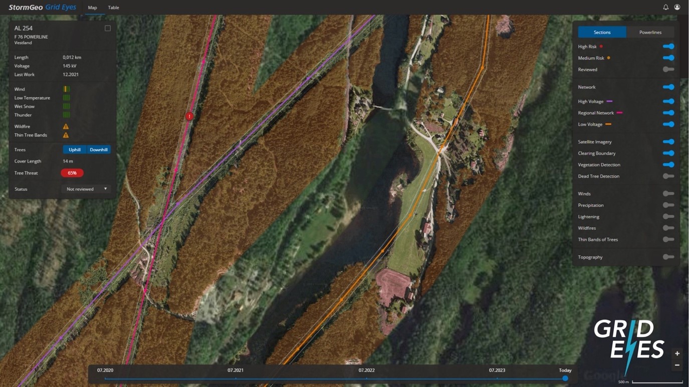
The demonstration phase validated that GridEyes meets these operational needs through a Software-as-a-Service platform designed for integration into existing workflows.
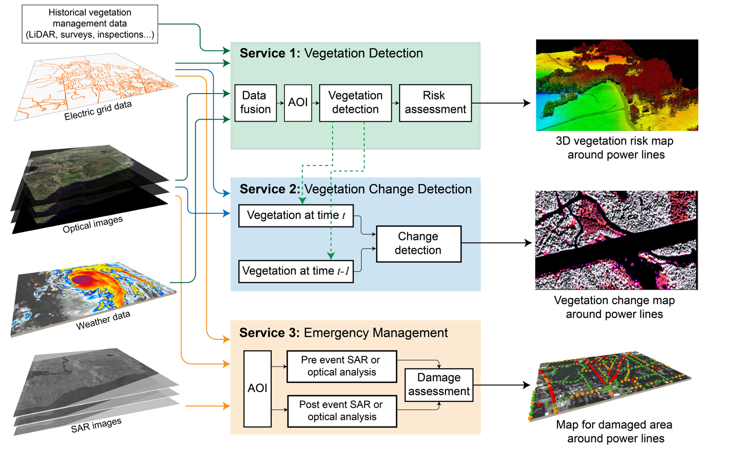
Service/ system concept
GridEyes provides geospatial intelligence through web and mobile applications, enabling structured decision-making and prioritization across large infrastructure networks.
The operational service includes:
Vegetation Detection
Monitoring and classification of vegetation within and near power line corridors using multi-resolution satellite data and AI-based modelling.
Change Detection
Identification of construction activity, forestry operations, land-use changes and other developments within rights-of-way.
Emergency Management Support
Rapid satellite-based assessment following extreme weather events, supporting situational awareness and response planning.
The system architecture integrates satellite data ingestion, AI-driven analytics and operational dashboards into a scalable cloud-based platform.
Space Added Value
GridEyes leverages Copernicus data, including Sentinel-1 and Sentinel-2 imagery, providing consistent, wide-area coverage and cost-efficient monitoring capabilities.
Commercial high-resolution satellite imagery from providers such as Airbus, Maxar, Planet, UP42 and ICEYE enhances spatial and temporal resolution where required. The integration of optical and Synthetic Aperture Radar (SAR) data strengthens monitoring reliability under varying weather and lighting conditions.
The ESA Business Applications program enabled the validation of this multi-source data approach and accelerated the transition from concept to operational service.
Current Status
The Demonstration Project has been successfully completed.
Key outcomes include:
- End-user validation sessions conducted with grid operators in Norway and Canada.
- Successful system demonstration covering large transmission corridors.
- Operational validation of AI-driven vegetation and change detection models.
- Dissemination of project results through national media, professional industry forums and the wider space applications community.
The project confirmed the commercial viability and scalability of GridEyes. The service is now operational and available to electricity network operators globally.
Availability
GridEyes is commercially available as a subscription-based service.
More information:
https://stormgeo.com/energy/predictive-grid-management