Objectives of the service
The proposed service is composed of two solutions, each addressing specific departments of the Transmission System Operators (companies in charge of the High Voltage electrical energy distribution):
- The department dedicated to the maintenance of the power infrastructure
- The department in charge of the network operations and energy dispatching.
The first solution provides the maintenance department with information about key parameters of the monitored overhead lines, without the need of site inspections; the information are provided several times per day, and allows the user to enhance the current inspection procedures, characterized by 2 to 3 site inspections per year.
The second solution provides information about line transmission capacities, to support the energy dispatch operations in critical conditions such as line overloading. Such criticalities may occur in different situations such as power lines outages or in proximity of Renewable Energy Sources due to unpredictable production peaks and are threats for the TSOs that need to guarantee power flux within safety limitations. The proposed solution intends to overcome the current conservative approach based on static estimations of network capacity, providing local and adjusted parameters that can be used to evaluate actual network capacity and to safely transmit power.
Users and their needs
The potential customers are the Transmission and Distribution System Operators. These companies are in charge of delivering the electrical energy along their overhead lines .
The identified user needs are the results of interactions with potential customers and assessment of the problems they usually face during normal operations.
After consultations, the users expressed the need to:
- receive information on pylon movements due to terrain subsidence.
- know the condition of the pylons in extreme events (earthquakes, floods, etc.) within 24 hours
- assess the dynamic capacity of their lines to avoid overloading
The first two needs are related to the knowledge of the integrity status of the pylons in a timely manner, more frequent with respect to the current situation.
The last need is related to the relevance of getting updated information about the operating conditions of the lines to improve transmitted energy.
The involved users are the Italian Transmission System Operator (TERNA) and the Slovenian one (ELES).
Service/ system concept
The proposed solution provides customers with updated information related to power infrastructures conditions, to support both maintenance procedures and energy dispatching operations.
The solution provides the following information:
- Pylons’ natural frequencies
- Positioning and displacement of the pylons
- Environmental condition (air temperature, wind speed and direction and Solar irradiation) over the entire network
- Conductor Temperature
- Estimates of the current capacities of the overhead lines
The natural frequencies are parameters correlated to damages in the infrastructure: this means that a change in their values are correlated to modifications of the mechanical condition of the pylons, possibly due to damages.
The knowledge of the actual environmental condition and the conductor temperature allows energy dispatcher to perform a more precise evaluation of the maximum amount of transmittable power.
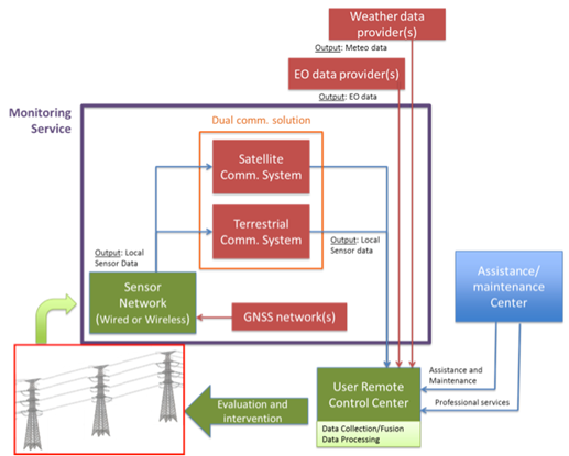
Such information is acquired by a network of sensors that are installed on some critical structures. These data are transmitted to the user control centre, and then integrated with space data coming from Earth Observation data providers and Weather service providers.
Space Added Value
The proposed solution exploits the following space assets:
- Navigation is used for the assessment of the pylons displacements in conditions where terrain is subject to landslides and slow movements. With sensors using the GNSS asset mounted on the pylons, the user can receive continuous updates on the structure remotely, filling the gap between ground inspections, which are currently run few times per year
- Earth Observation: Two type of Earth observation data are considered:
- Weather data used to support the energy distribution. Information regarding the current environmental condition (in conjunction with local sensors for specific areas) can be used to estimate the current capacities of the overhead lines.
- Synthetic Aperture Radar images obtained from satellites are processed using the Permanent Scatterers technique to measure displacements of objects on the ground.
The advantage of using EO images is that it allows to observe many structures within a single image. Such solution is used in conjunction with local GNSS sensors.
Space Telecommunication: the use of satcom is not crucial for the service deployment, but, could be used in areas where terrestrial telecommunications are scarcely available. Such a situation can often occur considering that High Voltage network are designed to avoid inhabited areas.
Current Status
The consortium completed the Final Review Meeting in January 2016. The Proof-of-Concept, performed in a real environment, included the installation of local device on a pylon belonging to an involved users and the development of a software package for data analysis and presentation. The results obtained from processed data demonstrated the technical capability of both the two proposed solutions: Integrity and Ampacity.
The provided Business Plans (one for each solution) demonstrated the economical sustainability of both solutions.
The demonstrated presence of both a reliable Business Plan and two space assets encouraged the consortium to prepare a request for Demonstration Project; an outline proposal is going to be shortly submitted.