Objectives of the service
Commercial aircraft, for safe operations, have to be able to communicate with air traffic control centres at all times. Communication is possible by VHF links whilst within range of the widespread network of ground stations, and is by HF radio in remote areas such as the Polar regions, the North Atlantic and Pacific where the VHF ground infrastructure does not exist (the Russian side of the pole only has HF capability).
This project is concerned with space weather influences on the ionosphere that impact on the propagation characteristics of HF radio signals and hence on terrestrial HF communication systems with particular emphasis on the high latitude regions. The focus is on the needs of the airline industry operating trans-polar and oceanic routes by providing nowcasting and forecasting information on HF communication signal strength for route planning in order to improve the efficiency and safety of operations.
Users and their needs
Commercial polar operations began in 1999 with a small number of proving flights. During 2001 there were 840 flights, and by 2018 the number had increased to around 20,000 flights per year. Further increases are expected.
When HF communications with the aircraft are expected to fail, the aircraft are re-routed avoiding the polar region with associated direct and indirect costs to the airline and passengers (one airline estimates the direct costs as €55k per day of disruption, other estimates published by the airline industry are higher). The minimisation of the additional costs relies on reliable HF communication predictions, which this project addresses.
The target market includes airlines operating polar routes and the various Air Traffic Control organisations. Users currently involved in the project are Iceland Radio, United Airlines, NATS, with involvement of Natural Resources Canada. We have investigated their detailed needs through a series of face-to-face meetings in order to define the information that the users would like presented and in what form. Their needs are diverse and a single web-based solution may not be appropriate.
Currently, the targeted users are based in the UK, Canada, the USA and Iceland, including airlines, air traffic control and communication service providers.
Service/ system concept
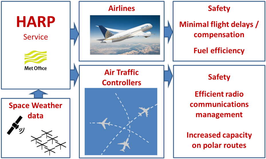
The HARP service monitors Space Weather, both at the current time, and several days into the future. The service gathers real-time data from both spacecraft and ground-based instruments to monitor solar flares, coronal mass ejections, geomagnetic disturbances, and other ionospheric conditions which impact HF radio communications at high latitudes. HARP translates this data into useful 24/7 information for HF communications operators, Air Traffic Controllers, and airline flight dispatchers.
The service advises users of the best available HF communications nodes (ATC transmitters), best usable radio frequency bands, and the probability of communications availability at all stages in each flight. Such information may be used as an operational decision-making tool for rescheduling trans-polar fights, selecting alternative flight routes and for commercial planning of passengers, cargo and fuel.
The HARP service also provides warnings of the potential impact of Space Weather events on forthcoming flights. The services of a dedicated “expert in the loop” Space Weather forecaster are also available, providing a bespoke service for customers.
Space Added Value
HARP uses real-time solar X-ray and energetic particle flux measurements from the NOAA GOES satellites to predict maps of HF radio wave absorption. Another space asset is the DSCOVR spacecraft stationed at a Lagrange point 1.5 million km “upstream” in the solar wind. This provides 30-60 minutes warning of shocks and compressions in the solar wind which can enhance HF absorption in the auroral zones. DSCOVR provides solar wind and interplanetary magnetic field measurements from which predictions of geomagnetic activity are derived and used to map auroral radio absorption.
Global navigational satellite systems such as Galileo and GPS are used to map the total electron content (TEC) in the ionosphere. HARP uses this information to indicate the prevalence of “polar patches” of ionisation, and the location of the main trough in the upper ionosphere. The HARP radio propagation models use this information to improve predictions of HF signal coverage.
Forecasts of solar flares and Coronal Mass Ejections require real-time imagery from the NASA SDO and the NASA/ESA SOHO satellites. The probability of each class of flare or solar energetic particle event (SPE) is translated by HARP into the likely impacts for aeronautical HF communications.
Current Status
Potential users were surveyed and their key operational needs identified. In order to satisfy these, a number of service delivery methods ranging from a simple web-based service to direct data feeds would be required.
Despite the users keenly supporting the HARP concept and providing technical input to define the requirements of the service, financial details and cost benefit analysis was not forthcoming due to commercial sensitivities. The users were also unwilling to commit to paying for individual access to the service. Consequently, it was not possible to build a strong business case to proceed to a demonstration project.
Many air traffic services are paid for at national regulatory levels through over-flight charges. All the users expressed a view that this may be an appropriate payment route. With the forthcoming introduction of 3 ICAO global space weather centres, the provision of a HARP service through these “free-to-use” centres will be considered.
Prime Contractor(s)