Objectives of the service

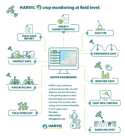
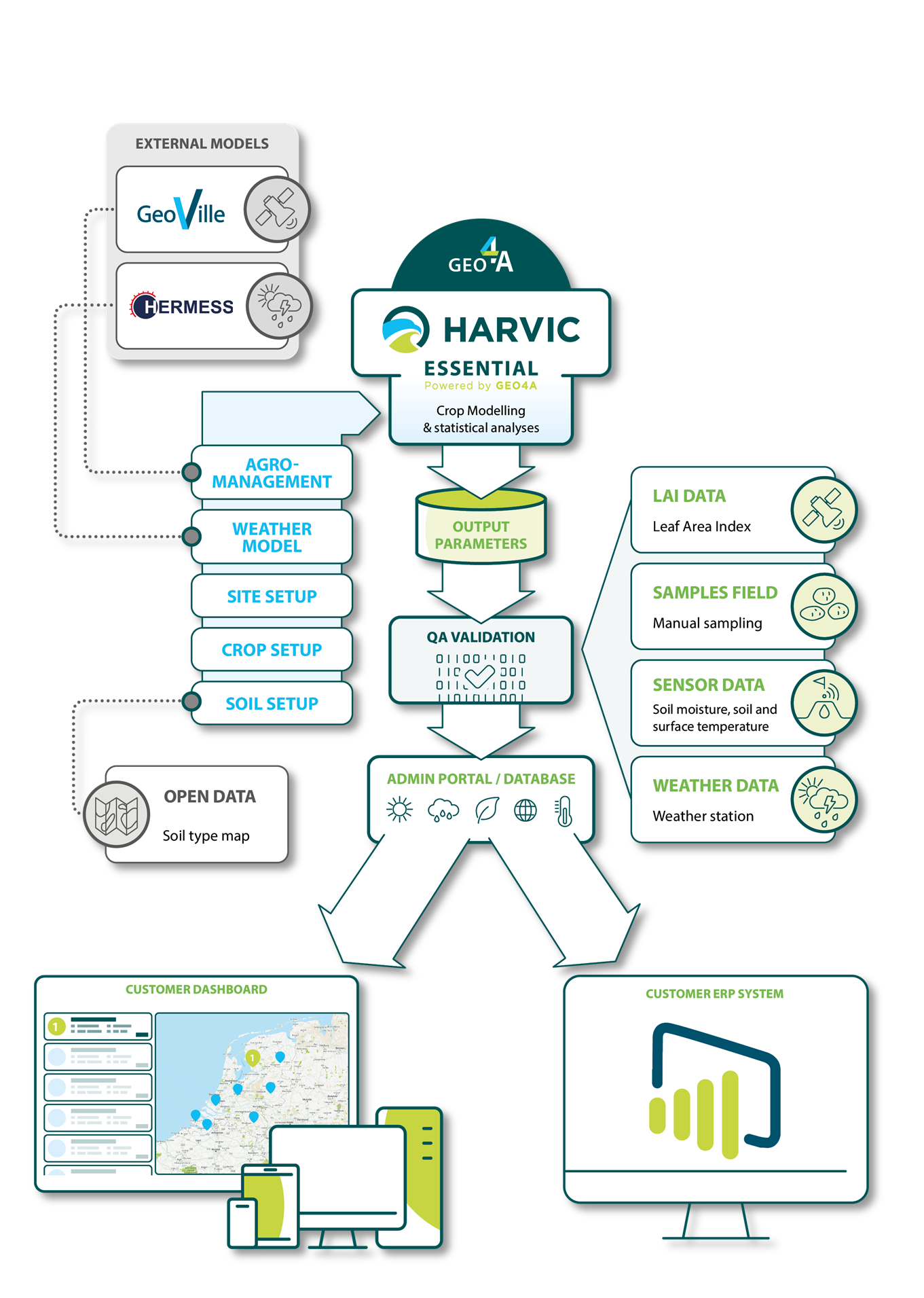
GEO4A offers HARVIC Essential, a marketable, end-to-end, actionable information service for the potato industry on crop-development, quality monitoring, and early forecasting of potato yield during potato growing season. HARVIC Essential gathers all relevant input field parameters and transforms these into quality and quantity indicators that provide the insights for companies to act upon. HARVIC Essential produces information, and the service is designed to be embedded in the decision-making processes from an operational to a strategic level at customer’s end.
The services support optimization of industry operations and guide the business decisions process such as field allocation for early export and maximizing resource logistics. HARVIC Essential make use of EO-data, combined with in-situ data acquisition and potato growth development modelling to provide near real-time remote-monitoring.
Hermess B.V. serves as external service provider for meteorological data. This service combines numeric model data, weather forecast data, corrected rain radar data, and station measurements resulting in an automatic selection of best available data with highest resolution.
GeoVille GmbH serves as an external service provider for Sentinel 1 and 2 data and performs data processing for determination of (dynamic) leave area index, leaf colour and emergence date and haulm killing timepoint determination.
Users and their needs
The feasibility study results confirmed a positive correlation between various vital field parameters and the potential to develop customized commercial indicators. As part of its mid-to-long-term business strategy, GEO4A aims to further expand HARVIC Essential by transforming these field parameters into additional quality indicators, as identified in the feasibility study, to address the specific needs and requirements of its customers and users. Overall, GEO4A is committed to continuously evolving and expanding HARVIC Essential services.
Customers in the potato sector prioritize faster access to data within the raw potato supply chain to optimize their business processes. The services provided streamline these processes by reducing the need for manual actions and collecting objective data from monitored fields. The challenges lie, on one hand, in encouraging this traditionally conservative sector to adopt these new services, and on the other hand, in helping companies transition to a new way of working rather than persisting with their existing methods.
Needs:
-
Yield estimation (actual & forecast)
-
Phenological Stages (ie. emergence & senescence date)
-
Crop Risk Control (weather related crop stress prediction)
-
Allocation of fields for certain purposes early in the season
Countries:
-
Netherlands
-
Belgium
-
Luxembourg
-
Germany
-
France
Service/ system concept
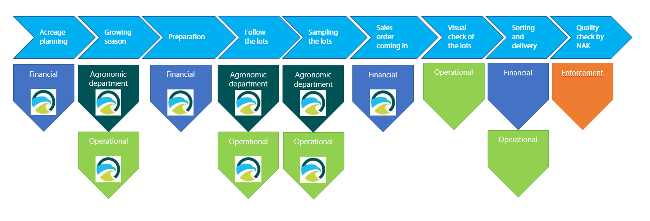
The data generated is utilized across three main departments within the potato industry (agronomic, operational, and financial department). For context, an example of a growing season's process flow is provided, covering stages from scheduling the production area to delivering the harvested potatoes to the customer. The data from our service tracks the potato growth process at the plot level. During plot monitoring, the data can be used, for instance, to guide field managers in inspecting a plot or to help the sales department estimate the expected yield. This data serves either as an input parameter within existing systems or as a standalone service for the customer. These services partially replace previously manual tasks within the companies.
Process flow at organizational level

Space Added Value
This DEMO project combined the strengths of various independent technologies to ensure optimal remote field monitoring and validate HARVIC Essential data and quality field information. HARVIC Essential utilized automatic processing of optical Sentinel-2 imagery data (L2A, BOA reflectance) to derive crop growth development parameters. To mitigate the impact of cloud coverage on Earth Observation (EO)-based parameter estimates, SAR (Sentinel-1) satellite imagery was incorporated to complement the optical data on crop condition, phenological state, and biomass estimates. Due to differences in wavelengths and energy-matter interactions, SAR data provided additional types of information compared to optical data, enhancing the overall understanding of crop status in the field.
Current Status
GEO4A is proud to announce the successful completion of the HARVIC project's final review milestone, marking the conclusion of this groundbreaking initiative. This achievement reflects the dedication of the project consortium, the invaluable support of the trial partner, and the strategic guidance provided by ESA.
Earlier, in late June 2024, the HARVIC Essential service platform reached a significant milestone by successfully completing an on-site acceptance test with a trial partner. This test validated HARVIC Essential's capability to seamlessly integrate agri-insights derived from satellite imagery into core enterprise resource planning (ERP) systems, demonstrating its potential for real-world applications.
The on-site acceptance tests showcased HARVIC Essential’s readiness to support the potato industry by delivering actionable insights and driving operational efficiency. As this chapter closes, GEO4A reflects with pride on the platform's role in enhancing decision-making capabilities and advancing integration across enterprise systems.
This project underscores the transformative potential of satellite data in agriculture while reaffirming GEO4A’s commitment to delivering cutting-edge tools that meet the industry's evolving demands.
During the project phase, the platform achieved impressive commercial results, with 45 units sold out of 90 produced, contributing over €100,000 in direct sales revenue. These early successes underscore the platform's alignment with industry needs and its ability to deliver tangible value. HARVIC Essential’s user-focused design has driven adoption, particularly in the Netherlands, where it secured five new partnerships, alongside three additional collaborations across Europe. These strategic partnerships have solidified its market presence and expanded its influence within the agricultural value chain.
GEO4A extends heartfelt thanks to ESA, the pilot trial partner, and everyone involved in making HARVIC Essential a success and looks forward to seeing the platform’s legacy continue through ongoing adoption and innovation within the agricultural sector.

Prime Contractor(s)
Subcontractor(s)


