Objectives of the service
Every megawatt hour of electricity produced but not delivered is extremely costly for Transmission System Operators (TSOs), Distribution System Operators (DSOs) and for the society as a whole.
The two HV-SATPROTEC services which are based on the integration of different space and non-space assets will provide users at lower costs with systematic and timely information on the state of the infrastructures and on potential threats in their surroundings. These services will support a more cost-efficient planning of necessary maintenance tasks, anticipate risks threatening overhead power lines and improve the overall safety of monitoring operations within transmission corridors. This will help to reduce the risk of power outages and to decrease the related high maintenance/recovery operation costs.
More precisely, the expected benefits for the two services are:
Expected benefits of service I, “Infrastructure surroundings”:
- Early detection of potential or actual threats allowing timely and focused interventions;
- More systematic and reliable information on threats to reduce fault risks and the associated downtime costs;
- More accurate information for a better planning of pruning operations;
- Reduced monitoring and maintenance costs;
Expected benefits of service II, “Infrastructure integrity”:
- Accurate information for a better planning of infrastructure repairs to reduce the associated costs;
- Systematic information on infrastructure integrity to reduce risk of faults and the associated downtime cost;
- Increased safety thanks to the reduction of climbers’ inspections or helicopter flights.
Users and their needs
The target users are Transmission System Operators, Distribution System Operators and their maintenance service providers. Representatives of all of these groups have been involved in the project.
The main relevant user needs identified are:
- Improved assessment of distances between critical objects (vegetation, buildings etc.) and overhead lines;
- Systematic characterisation of overhead line surroundings;
- Systematic detection of thermal anomalies;
- Systematic detection of damaged insulators;
- Reliable assessment of corrosion on transmission towers and substations;
- Detection of transmission tower location and deformation
The main concerns of the TSOs are currently:
- To reduce the cost of their maintenance and recovery operations
- To improve the performance of the process for detecting environmental hazards and infrastructure faults.
- To reduce the time for recovering infrastructure after extreme events
- To improve the safety of their field agents
The target countries are mainly in Europe, but also industrialised countries outside of Europe are in the scope of the services.
Service/ system concept
The HV-SATPROTEC services consist of a comprehensive set of information layers on changes in the surroundings of the transmission corridors, potential threats in the vicinity of assets and different types of infrastructure damages. These data sets are provided along with detailed high quality images for easy visualisation and systematic documentation. Here are the main elements of the two HV-SATPROTEC services:
- “Infrastructure surroundings”:
Regularly updated maps on corridors and surroundings allow the detection of potentially critical changes of land cover and activities. The service provides further detailed assessments of critical distances between overhead lines and potential threats in the vicinity, like trees growing close to the lines or new (illegal) constructions.
- “Infrastructure integrity”:
This service provides systematic and accurate information on damages on transmission towers and lines (e.g. broken insulators, hot spots, corrosion). On demand potential transmission tower deformations are mapped (e.g. after strong storm events) supporting quick recovery operations.
- As a prerequisite a baseline mapping of tower locations is provided on demand.
The services will be updated in regular intervals (e.g. annually) or on demand and will smoothly integrate in users’ in-house asset management systems through the provision of tailored service outputs.
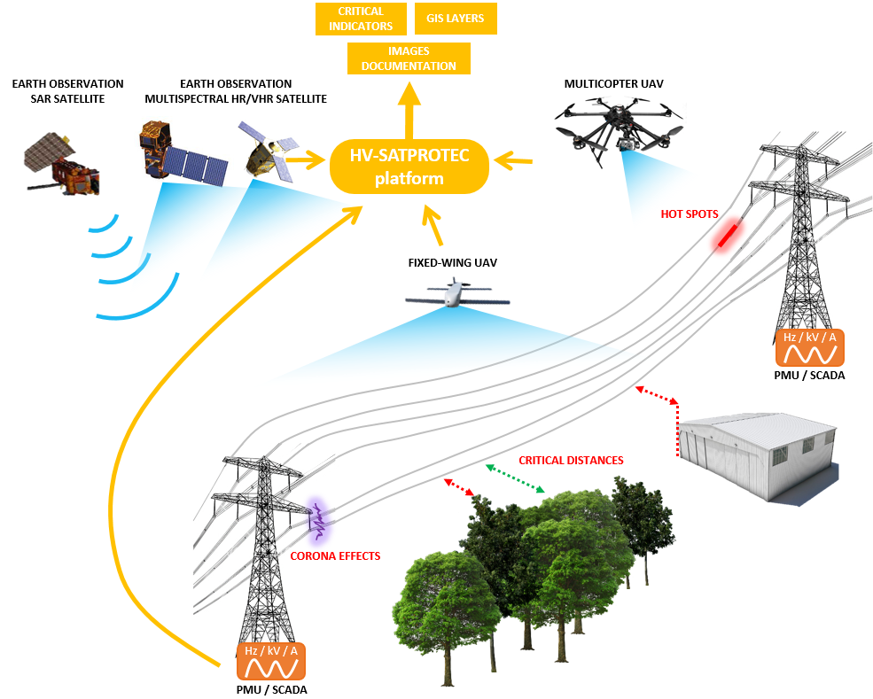
Figure 1 - HV-SATPROTEC system overview
Space Added Value
The HV-SATPROTEC services integrate the following space technologies:
SatEO:
- Transmission tower localisation and deformation detection based on SAR satellite data.
- Mapping of land cover/use change within and in the surroundings of transmission corridors based on high resolution multispectral satellite data.
- Inspection of objects and vegetation in critical distances to power lines in urban areas utilizing stereo-optical VHR satellite data
SatNav :
- Coverage of a global navigation satellite system (e.g. GPS or in the future Galileo) is crucial for precise location and autonomously conducted flights of Remotely Piloted Aircraft Systems (RPAS) over transmission corridors, following pre-defined coordinates.
SatCom:
- SatCom usage will become relevant in the future when providing the services in areas where beyond visual line operations of RPAS are allowed but terrestrial network coverage is missing.
Current Status
The study has been completed successfully with the Final Review held in July 2015 at ESA-ECSAT in Harwell. The study was launched on April, 30th 2014 in Lausanne. A user workshop has been held at EPFL, Lausanne, Switzerland on June, 30th 2014 in order to consolidate user needs and requirements. The first two tasks, the “User/Stakeholder Analysis & User requirements definition” and the “State-of-the-Art Analysis & Technology Identification”, have been achieved and reviewed at a first progress meeting at end of July 2014. The third task, “Service and System Definition”, has been carried out before the mid-term review meeting held at Fingrid’s premises in Helsinki mid-November 2014. Task four, the “Proof of Concept”, covering the validation of critical system and service elements and task five, the “Economic and Non-Economic Viability Analysis” were finalised before the second progress meeting end of May 2015 in Lausanne. Task six, the last stage of the project, has confirmed the feasibility of the services and defined a roadmap and recommendations for further developments towards operational services. A follow-up demonstration project within ESA’s IAP Programme is currently under discussion/preparation.
Prime Contractor(s)

Subcontractor(s)