
Objectives of the service
Although, many projects in Public Safety have delivered useful, innovative results, not all of their results are used on the long term, often because of inadequate business model. By investigating critical risk use cases concerning technological hazards in Belgium and food security in Senegal, the Study wants to demonstrate that a “global” approach brings significant benefits, compared with traditional segmented approaches that impede the construction of viable business models.
The objectives of the Study are:
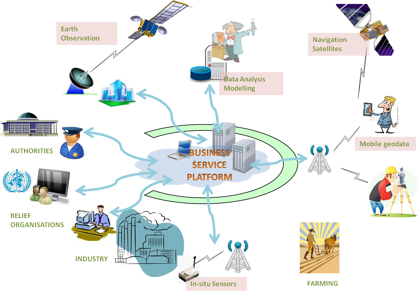
- Design a “Business Service Platform” and its associated business model, which facilitates the trading of added-value geospatial information, thus enabling the creation of an “e-marketplace”, where all the stakeholders contribute to the sustainability of the value chains.
- Define solutions based on upcoming Earth Observation and Navigation assets that will enhance the awareness and response efficiency for technological hazards in Belgium and for food insecurity in Senegal.
- Identify the players and define the services that they will value, in order to ensure the long term funding of the technologies to be implemented and the basic services to be deployed.
Prepare the technical and financial scenarios for a successful implementation of viable services covering the targeted users’ needs and beyond.
Users and their needs
The Study has selected two different risk scenarios in two continents. The first scenario concerns Belgium, where, for centuries, industrial activities have developed in the middle of a dense population, raising today critical concern about the risks for the citizens, e.g. accident in a factory, ground instability caused by ancient mining and quarry activities. The second scenario addresses the tremendous challenge that low agricultural productivity and risks on the yield (weather, pest, losses) put, in Senegalese municipalities, on the local authorities, who often lack of reliable local information for anticipation and decision-making.
The main targeted users’ communities are the local authorities (municipalities), the regional and national institutions in charge of risk prevention, mitigation and intervention, and the first responders of the Civil Security services. The stakeholders involved in the production (e.g. industrial enterprises and engineering companies in Belgium, farmers and suppliers of inputs for agriculture in Senegal) and in the services (e.g. experts, financial institutions) are also targeted as they are consumers of added-value services generating potentially significant revenues.
Major needs addressed in Belgium:
- Prevention and intervention planning in the context of the application of the EU SEVESO 3 Directive to hazardous sites;
- Ground instability (subsidence) monitoring and impact assessment in the areas of ancient and current underground activities (old coal mines, geothermal drilling, lime quarries, etc);
Major needs addressed in Senegal:
- Land tenure delimitation and registration in rural areas
- Crop monitoring and yield and harvest forecast at local level
- Food balancing between abundance and deficit areas.
Belgium, Senegal.
Service/ system concept
The Business Service Platform allows, in a value chain, stakeholders to efficiently measure, evaluate and control the performance by sharing the sources of data and exchanging added-value information. This platform comprises common generic components and, in the context of the study, two applicative segments.
The main generic components implement the user interface through the web and through the mobile telephone and ensure the management of interchange among the stakeholders.
The Public Safety applicative segment provides:
- Preparedness planning dedicated to industrial risks (site mapping, atmospheric dispersion, logistics, evacuation)
- Subsidence monitoring using Sentinel-1, ground based metallic corner reflectors and on the field data collection with mobile devices
- Hazard damage assessment and compensation monitoring.
The Food Security applicative segment provides:
- Arable Land management enabling a secured land attribution, land taxation, securities for credit and commercial transactions, as well as agricultural insurance services
- Crop season monitoring at local scale comprising alerting on sowing dates, crop growth estimates, yield forecasts using available crop models
- Food distribution monitoring taking into account the household need survey data, the crop production, product storage locations and inventories for better balancing between abundance and deficit areas.
Space Added Value
The system ensures the collection of up-to-date, near-real-time data from different sources: Earth Observation (e.g. Sentinel 1 interferometer), time and location referenced mobile data (e.g. land tenure limits by a surveyor), public and private data bases (e.g. cadastral registry) and possibly measurements from in-situ sensor networks.
The system requires mandatorily Earth Observation and Navigation Satellite Infrastructures to deliver the services to the stakeholders in Belgium and in Senegal. Communications satellites are considered in Senegal, in rural areas, where the ground telecommunications infrastructures are not available.
The use of SENTINEL-1 radar data is foreseen as the single source of information for ground deformation measurement, as it provides rapidly available data over the same areas with high recurrence (every 6 days with tandem satellites) at affordable cost.
The provision of services at local scale for the crop monitoring requires multispectral wavebands at 20M resolution images from SENTINEL-2.
Precise geo-positioning with GNSS is required for most of the services, as they integrate in-situ collected data using mobile phone devices with geo-positioning capability. Additionally, the surveyors on the field need high precision centimetre positioning for the correct delimitation of the land parcels.
Current Status
The study work is completed. The main results are:
- The business model, based on three levels of stakeholders, has been refined and used in the definition and segmentation of the services for Public Safety and Food Security.
- The services to be delivered to the Public Safety users in Belgium and Food Security users in Senegal have been specified, in response to the needs and requirements collected and the overall architecture of the Business Service Platform has been drafted.
- A detailed analysis of the costs and revenues for the provision of the targeted services was performed and the economic viability conditions have been assessed, enabling the definition of a roadmap for the operational activities.
- During the Study, opportunities for complementary services were identified (e.g. concerning forest management), increasing the confidence in the viability of the solution.
Based on the proposed roadmap, further exploitation and related investment must be decided.
Prime Contractor(s)

Subcontractor(s)