

Objectives of the service
The Illegal Logging Detection and Prediction (ILDAP) application detects illegal logging activities and anticipates possible future illegal logging instances. By analyzing various patterns, such as settlement developments or road construction, ILDAP predicts illegal logging activities as well as the functionality of dispatching near real-time alerts to users ensuring timely and effective responses. The ILDAP application harnesses Artificial Intelligence (AI), Geographic Information Systems (GIS), and the latest remote sensing data analytics, providing users with strategic and impactful insights. Beyond its core functions, it can help to ensure the preservation of biodiversity and carbon stocks, making it a valuable tool for landowners, managers, project developers, NGOs and their sponsors.
Users and their needs
In the ever-expanding global environmental monitoring market, long-standing challenges persist for customers. These challenges include getting accurate and timely reporting of illegal logging, acquiring resources and funding, tackling corruption and operational inefficiencies, navigating weak government policies, and organising interventions against illegal logging activities. ILDAP’s innovative solutions address several of these problems. Our customers receive actionable insights and near-real-time alerts enabling them to intervene and combat illegal logging activities through advanced detection, predictive capabilities, and more accurate reporting. This enables for better protection of forest assets, reporting to sponsors and appropriate allocation of resources.
With ILDAP, the shift towards proactive forest management and the mitigation of environmental crimes is here to connect forest managers, local communities and actors, indigenous people (IPLC), forest conservation project developers, and sponsors in a single transparent source.
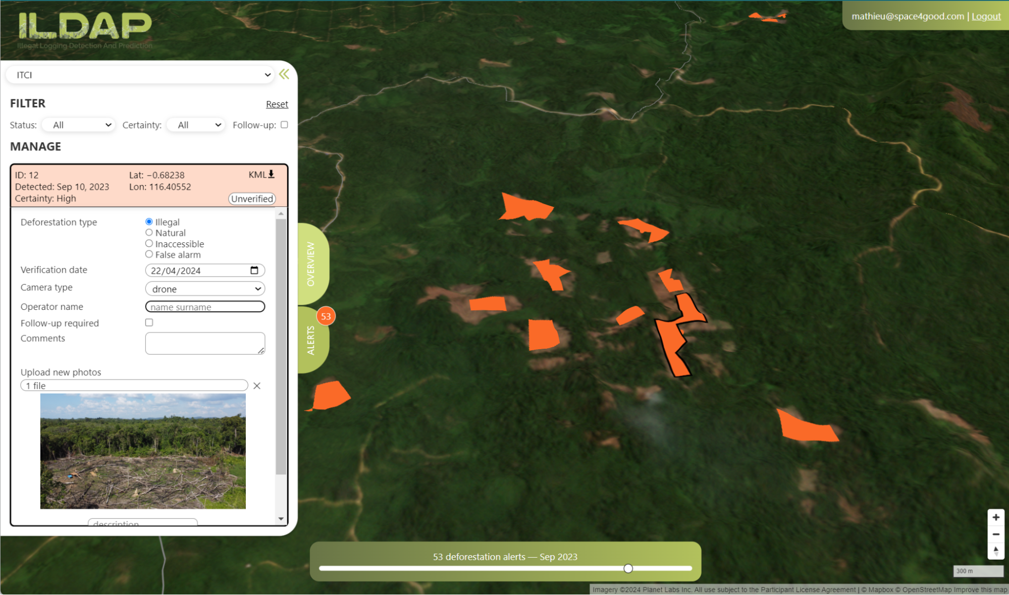
Service/ system concept
The system is divided into four distinct feature groups.
The first feature is dedicated to logging detection, a central purpose of ILDAP.
Thanks to the detection using Sentinel 1 radar data, which is capable of penetrating clouds, alerts can be generated. In tropical regions with extensive cloud cover, this capability is invaluable. The system issues alerts to users based on changes in forest structure (scattering), which are displayed on the ILDAP portal. Users can manually validate the alerts through field observations or drones with predetermined, computer-generated flight parameters. This enables them to confirm illegal logging activities faster and more accurately, facilitating more effective mitigation.
The second feature pertains to prediction. It involves mapping risks for illegal logging based on several topographical, weather, vegetation, and economic contextual parameters. These parameters are processed using machine learning AI methods capable of handling large training datasets. Predictions allow users to take preventative measures, and more concisely allocate resources, such as engaging with local communities or increasing patrols in the area.
The third feature encompasses deforestation trends and contextual layers. Here, users can compare historical data, conduct annual comparisons, gain insights into trends, and assess the rate of change in deforestation and other relevant forestry and environmental information. This group aims to foster a comprehensive understanding of the area of interest.
The final feature facilitates operation and communication of insights within the forest stewardship team. Operational messages and alerts are directly dispatched to field personnel, either via the platform, email or WhatsApp depending on their preferences. In addition, tools to simplify the reporting, investigations and disseminations are available on an easy to use web platform, catering to the needs of managers, project developers and sponsors.
Space Added Value
The utilisation of satellite remote sensing enables automated impact reports on illegal logging, offering numerous advantages including: (a) rapid near-real-time insights, (b) expansive area and global monitoring, (c) accuracy and precision down to the hectare, (d) and cost-effectiveness. ILDAP significantly improves upon conventional products in the environmental monitoring market by introducing unparalleled event accuracy and illegal logging prediction capabilities (a feature virtually unprecedented for customers until now) as well as integration within contextual workflows for optimum utilisation.
Current Status
As of May 2024, the platform is ready for operation and support several areas in tropical regions. Some of our key accomplishments over the past months are:
-
Deforestation detections over the past 3 months are more than 10x the number of detections over free online platforms, with no false positives
-
The first prediction model is undergoing testing to identify accuracies and tailor output representation to use cases, with already proven results of avoiding new illegal settlement in Indonesia.
-
The platform is ready and is being rolled out slowly to ensure operational certainty on the new pilot area.
Space4Good aims to extend its pilot campaign to other areas and organisations across the globe. For more information or if you have an interest in partnering with us, please contact hello@space4good.com.