Objectives of the service
Stability Monitor is web application developed by CGI IT Czech republic s.ro.. The application delivers information regarding ground movement of client’s area of interest, assessing not only the risk of the territory to move or fail, but the long-term trend of such movement and related statistical information. The potential clients of the solution are insurance and development companies (spatial/urban planning, architectural and engineering offices), taking care of real estates.
The potential customers already use certain manual methods to assess and monitor ground stability or rely on industry experience and other information provided by various resources. However, all the methods require significant amount of time for the actual observations and in case of third-party assessment increase the cost of the claim assessment. The proposed CGI Stability Monitor solution significantly reduces the time, labour and cost demands due to fully automated acquisition of high-resolution satellite imagery and their evaluation. This enables long-term stability monitoring in the area of interest and fast identification of stability changes. The solution provides user friendly interface for visualisation and easy interpretation of results in relation to each parcel in a cadastral register for the whole prepaid perimeter.
Users and their needs
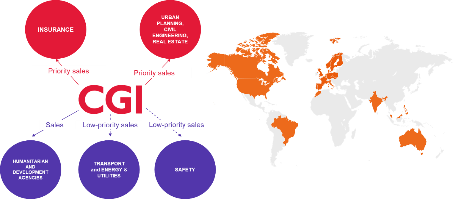
In the insurance organizations, the end-users will be mostly insurance agents, who manage a certain monitored area/parcel/property. These users have basic skillset and expertise in the area of stability monitoring, therefore their needs for the solution are quite straightforward. The requirement for these users is to have:
-
solution providing easily interpretable information for the monitored area with clear user-friendly design,
-
long-term monitoring overview of the area of interest - to ensure correct risk evaluation, assessment of the insurance claim or setting of correct insurance limits,
-
long-term stability monitoring.
In case of Civil engineering/Real estate sector, the targeted end-users will be most likely architects, construction planners/designers or managers and civil engineers. These users have intermediate to advanced skillset and expertise in the area of stability monitoring, therefore the information in the solution should provide:
-
sufficient level of detail for reliable area assessment,
-
initial stability evaluation of a parcel/area prior construction,
-
evaluation of building stability or interim evaluation during construction works,
-
easily and quickly interpretable information in relation to each case.
There are also other sectors (Non-profit, Energy & Utilities, Transport, Safety) that can benefit from the Stability Monitor solution and will be addressed after the initial success in sectors mentioned above.
Service/ system concept
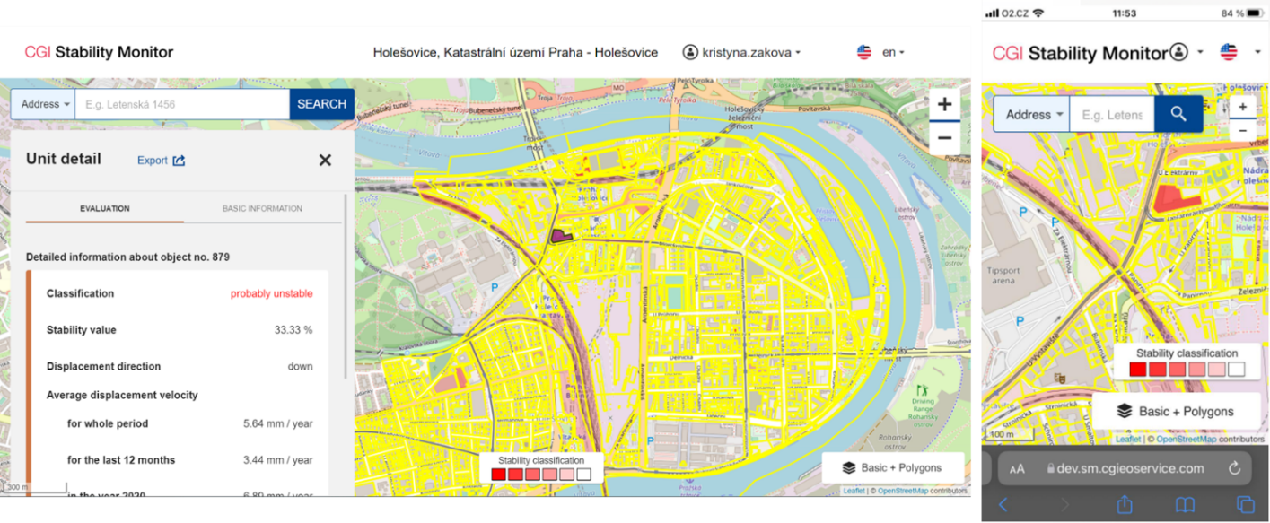
The solution is based on InSAR analyses, which is considered as an effective way to measure changes in land surface altitude. The technique measures millimetre-scale changes in deformation over spans of days to years. The Stability Monitor will visualize aggregated information about permanent scatterers (PS) shifts in a predefined area of interest.
The solution shall be a web application with the presentation of (cadastral) building units and the vertical movements observed in the specific area, determining the level of movement (from none to potentially harmful) and visualizing the long-term trend in the graph, allowing the user to search for specific unit with different search options – by the address, cadastral ID, etc. For each client, separate user profiles shall be created to restrict the clients to previewing only areas of interest that were identified by them (some insurance companies may only limit their activities to specific regions etc.), having every client accessing only the areas they paid for, not less or more. The areas chosen (and therefore the vertical movements measurements) shall be updated regularly as per client’s deal and need, but update once per six or twelve months is considered reasonable.
Space Added Value
The market offers various solutions for vertical terrain movement monitoring and identification. The conventional solutions require in most cases special measuring equipment and expert surveyors for their operation. The methods often offer different precision, which means that their usage may vary case by case. Stability assessment conducted by using conventional solutions also takes much longer time due to the whole process span – procuring the survey, the actual survey execution, data evaluation and final protocol preparation.
The most of the current EO solution are targeted towards expert community due to difficult interpretability of data and wide range of advanced functions. These solutions are based on point measurements with the absence of polygon generalization. Also, the solutions mostly offer only data processing without data presentation mode.
The CGI developed Stability Monitor solution is filling the market gap by combining user friendly interface, with easily interpretable data. Our solution can be used both by expert community as well as general public. CGI Stability Monitor also has a competitive price compared to solution already on the market, therefore can be deployed by stakeholders seeking a functional solution with reasonable price.
Current Status
CGI Stability Monitor solution has been successfully developed. The solution is deployed online, functioning as a web application available through any internet browser the end user might use, optimized not only for computer/laptop access, but also for mobile access, allowing use of all the application’s functionalities to most ordinary end-users. The InSAR results are presented in an easy-to-understand polygonised way with additional information, graphs, visualizations etc.
The solution is in multi-language model, allowing the application to be presented in different language mutations (currently available in English and Czech) and also multi-tenant, distinguishing and separating each potential entity’s space, information and added-values assets, considering basic security needs of potential customers.
Access management is in place and deployed, allowing the users to have different roles (and different associated rights), considering hierarchy and the fact that different roles within the organization have different rights and need-to-know status related to information available.