Objectives of the service

Because of the steady increase in the number of insured agricultural fields in Poland, traditional methods of claim settlements performed through field inspections are no longer efficient enough. The high number of claims and demands on their execution in a short period of time is considered by insurance companies to be a huge logistical and financial effort.
The main objective of the InsSAT service was to offer a fully functional and operational system of automatic processing and analysis of satellite, meteorological and if necessary also aerial data, focused on providing tools for assessment and settlement of insurance claims in the agricultural sector.
System development covers not only the elimination of damage in the field, but also the creation of risk maps. On the basis of historical satellite and aerial data, as well as archival information on damage occurrences, areas with the highest risk of damage can be identified. Such information allows insurance agencies to adjust their offer and costs for areas of higher risk. Continuous satellite monitoring of the insured plots is needed to estimate the risk and future compensation costs before the damage is reported by farmers.
Users and their needs
The pilot users of the InsSAT system are the insurance companies offering services to the agricultural market in Poland. User needs have been identified and are listed below:
- Crop condition assessment
- Crop location during the sales season
- Information about water reservoir areas
- Liquidation of damage caused by drought
- Information on the date of harvest
- Liquidation of frost damage and its risk
- Analysis tools (e.g. ordering and printing reports)
- Statistics
- A more effective process of collecting field data
Service/ system concept
The concept of the InsSAT system is to provide comprehensive functionalities for the agricultural insurance sector which includes integration of synchronized mobile and web applications. The mobile application offers preview of satellite-based analyses, which facilitate the execution of additional field measurements.
The proposed system relies on using Earth Observation data, the most important source being satellite images from Copernicus (Sentinel-2 and Sentinel-1) as well as NOAA AVHRR and MODIS. They are necessary to calculate vegetation indices (e.g. NDVI) and parameters that are the basis for analysing the crop condition. Complementary data are field measurements, land cover maps, cadastral, ARiMR (Agency for Restructuring and Modernisation of Agriculture) and weather data. Integration of all these data sources is required to ensure the highest quality and accuracy of analysis.
One of the project's goals was the automation of analysis in order to minimise any operator-based bias within the processing.
Included in the system are ready-made products such as crop condition and drought maps from the ASAP (“Advanced Sustainable Agricultural Production”) Demonstration Project, which are tailored to the insurance industry’s needs.

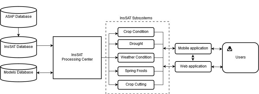
High level architecture of the InsSAT System
Space Added Value
The use of remotely sensed data in the agricultural insurance sector brings clear benefits both for insurance companies and their customers. Traditional techniques of claims settlement are no longer efficient enough and require significant resources in terms of money and time, being prone to inaccuracies during the process of damage assessment.
The use of satellite and other remotely sensed data allow the simultaneous analysis of huge areas and numbers of insured fields whilst maintaining consistent reliability of the obtained analyses.
The main sources of spatial data included in the InsSAT project include:
- Copernicus Programme satellite products from:
- Sentinel-1
- Sentinel-2
- NOAA AVHRR / MODIS based drought maps
- Terra MODIS surface temperature and snow coverage data
- Aerial data (for correlation between plant density and NDVI, and to calibrate the satellite images)
- Meteorological data from ICM UW models (Interdisciplinary Centre for Mathematical and Computational Modelling, University of Warsaw) based on the global weather forecast model of the UKMO (UK Meteorological Office)
- GNSS-based field measurements
- Land cover maps
Current Status
During the InsSAT project a comprehensive system has been built , consisting of the InsLAB web portal, InsLAB mobile application, developed models, products and highly automated processing chains, bringing measurable financial benefits to its users. This system is a response to an increasing insurance market demand that requires a new and more efficient approach to their daily work in many different departments. A set of thematic modules have been added to the InsLAB web portal to address specific requirements of different types of end customers and the system has been built in such a way that adding new modules and functionalities is always possible in case a new demand is defined in the future. Although, at the moment, only insurance companies actively use the provided services the InsSAT consortium plans to gain new customers coming both from insurance sector and from different areas of the agricultural market.
One of the main achievements of the InsSAT project from a commercial point of view is a successful transition from basically free-of-charge first pilot projects to commercial activities that were won on a free and competitive market (e.g. delivering 1700+ crop harvest day reports).
The team involved in the InsSAT project have gained professional and unique knowledge, know-how and skills that will be further exploited in order to deliver the most innovative solutions in line with the evolving market requirements.


