Objectives of the service
The management of offshore structures at the end of their productive life and the definition of the environmental and socio-economic impacts related to the possible applicable solutions, have become increasingly important in recent years. Emerging economies, such as the “blue economy” are leading the way to the development of innovative solutions respecting environmental, social, and economic sustainability.
INSURE wants to make use of all the ESA’s remote sensing and communication assets, like Global Satellite Navigation Systems (GNSS) and Satellite Communications (SatCom) for environmental control and guidance of autonomous vehicles such as Remotely Piloted Aircraft Systems (RPAS), and Unmanned Maritime Systems (UMS) operating in the area under decommissioning in addition to the Earth observation (EO) of Copernicus for environmental control. In addition to this constellation of satellites, laser-based technologies will be implemented on board of RPAS for a more detailed and prompter monitoring of the area.
Core of the INSURE system is an augmented virtual reality platform (AVRP) that will be operated at strategic level of the decommissioning decision making hierarchy and where all the data acquired/transmitted by the plurality of sensors will converge. The AVRP will improve the overall situational awareness of the operators with the possibility of tracking assets and personnel, planning activities and it will support with quantitative data contingency plans in case of failures and/or operational setbacks also providing automatic generation of alarms in case of need.
Users and their needs
The user community targeted are stakeholders and authorities operating in this specific field of offshore decommissioning operation. On top of all international, European, and national regulatory bodies provide the regulatory framework guidelines, define the procedures/best practices, and put in place the controls through the devoted agencies. At national level, the regulatory body publishes once every year a list of platforms and infrastructures no longer useful for the oil & gas business; among these, the regulatory body identifies some for a future potential re-use. New emergent opportunities in renewable energy production can be potentially addressed by INSURE to monitor large farm factories (photovoltaic, wing and green hydrogen) in offshore marine or inland fixed or floating installations. This list allows potential stakeholders to propose re-use projects to give a “new life” to these assets.
INSURE has already interviewed different national and international stakeholders, involved in this type of operations, including private companies interested to expand their business opportunities in support to the current green revolution. Below here is reported a shortlist of indications and “nice to have” solutions collected during interviews held with groups of investors interested to operate in this field.
-
Strong emphasis on the environmental aerial/marine monitoring, including the meteo-marine condition forecast;
-
Development of "underwater highways", including charging stations for resident UMS devoted to environmental surveillance and monitoring;
-
Realisation of an integrated energy islands (solar, wind, H2) to support maritime productivity activities;
-
Transformation to sea-farming solutions associated with cultural recreational or commercial activities (rig-to-reef and fishery);
-
Realisation of communication nodes/hubs;
INSURE is presently targeting the large number of Mediterranean offshore gas platforms but the proposed approach can be tailored to worldwide opportunities.
Service/ system concept
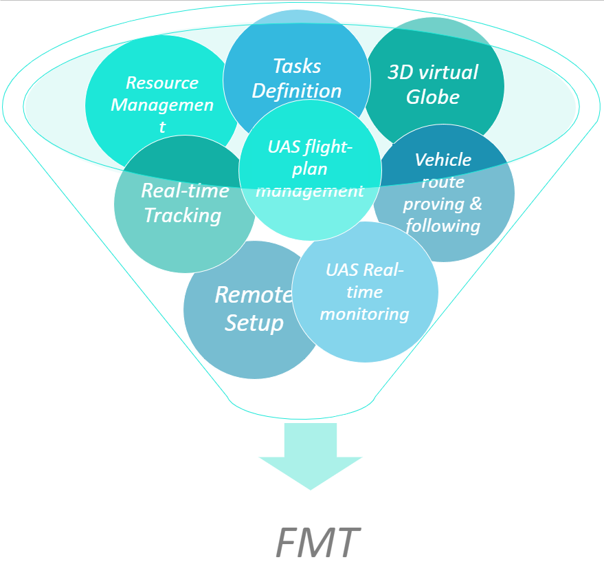
Fleet Management Tool (FMT)
INSURE system collect the information from different space satellites and local remotely operated vehicles thanks also to the different high speed communication channels.
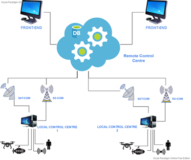
This huge amount of data is firstly stored in a cloud infrastructure and successively passed to an augmented virtual reality platform (AVRP) that operates at strategic level of the decommissioning decision-making hierarchy and where all the data acquired/transmitted by the plurality of sensors converge. The same AVRP integrates a 3D Geospatial tool that allows to manage and visualise all the geo-referenced info in real-time with different dynamic views. New EO+5G+RPAS+UMS tools are integrated. The AVRP improves the overall situational awareness of the operators with the possibility of tracking assets and personnel, planning activities and it supports with quantitative data contingency plans in case of failures and/or operational setbacks also providing automatic generation of alarms in case of need.
Provides a solution for:
-
Managing resources
-
Planning tasks
-
Real-time monitoring of tracked assets
-
Post operational analysis
-
Digital reports
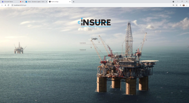
The FMT is based on different software applications:
-
C-FMT: Central Application; R-FMT: Web-Application
-
M-FMT: Mobile Application; V-FMT: Vehicle Mobile Application
Space Added Value
Core component to the INSURE system are the ESA space solutions as:
-
Earth observation (EO) of the Copernicus system for environmental control as:
-
Sentinel 1 radar images,
-
Sentinel 3, spectrometer data and marine temperature
-
Prisma, hyperspectral data
-
-
Global Satellite Navigation Systems (GNSS), European Geostationary Navigation Overlay Service (EGNOS)
-
Satellite Communications (SatCom) for the control of autonomous vehicles such as RPAS and UMS operating in the area under decommissioning
Extensive environmental monitoring of area under decommissioning is accomplished with Laser Induced Fluorescence (LIF) sensors operating on-board RPAS (sea-surface monitoring) and UMS (subsea monitoring). Real world reconstruction of subsea environment and assets will be acquired with a 3D underwater laser scanner to improve precision in underwater operations and positioning for assets removal.
5G technologies play a fundamental role for the project, since it offers enhanced Mobile BroadBand (eMBB), Ultra Reliable Low Latency Communications (URLLC), and massive Machine Type Communications. eMBB is a key requirement especially for AR/VR applications, since they require transmitting data with very high bitrate, while URLLC is fundamental to guarantee delay-free AR/VR/3D/Sensors/Robotics experience
Current Status
The feasibility study was completed in June 2022.