
Objectives of the service
The main objective of the project is to provide comprehensive mobile application for immersive nautical tourism, safe inland waterways navigation, active water sports and for better communication and integration of users. The proposed IntVAR mobile application will support whole water tourism, especially sailors, fishers, kayakers, divers, water rescue services. The integration of GNSS and VR/AR technologies combined with satellite imagery offers new technical opportunities to improve travel safety and to help avoid dangerous navigation obstacles. VR technology provides remote underwater travel and navigating by the digital seabed model. The use of augmented reality in the water navigation will not only support safe travel on the water, but it will also securely guide the user to the specified destination. The application will suggest and indicate the most exciting route. It also enables communication and interaction between users.
Users and their needs
The main objective of the project is to provide comprehensive mobile application for immersive nautical tourism, safe inland waterways navigation, active water sports and for better communication and integration of users. The proposed IntVAR mobile application will support whole water tourism, especially sailors, fishers, kayakers, divers, water rescue services. The integration of GNSS and VR/AR technologies combined with satellite imagery offers new technical opportunities to improve travel safety and to help avoid dangerous navigation obstacles. VR technology provides remote underwater travel and navigating by the digital seabed model. The use of augmented reality in the water navigation will not only support safe travel on the water, but it will also securely guide the user to the specified destination. The application will suggest and indicate the most exciting route. It also enables communication and interaction between users.
First, we would like to implement the product in Poland and then also in Europe
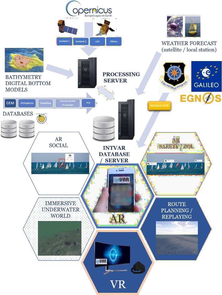
Service/ system concept
The software available on the market is dedicated to specific aspects of spending free time on the water. It is limited to core services, such as water navigation, sailor's/ports guides, travel&local guides, communications, and social applications. There is no complete solution that would offer all functionalities in a single system. The proposed IntVAR solution would fill this gap by providing all the features for water tourism in one place.
The proposed mobile application with the web front-end is a platform supporting users interested in actively spending time by the water. The integration of GNSS and VR/AR technologies combined with satellite imagery offers new technical opportunities to improve travel safety and to help avoid dangerous navigation obstacles. The use of augmented reality in the water navigation will not only support safe travel on the water, but it will also securely guide the user to the specified destination. The application will suggest and indicate the most exciting routes. VR technology provides virtual tours on the digital seabed model based on recorded routes from shipping logs. It also enables interaction between users. The overall architecture of IntVAR system is shown in the figure below.
Space Added Value
The project concerns the construction of a modern mobile application utilising VR/AR technology, GNSS and satellite imagery. The proposed product is based on two big programmes offered by the European Space Agency (ESA): the European Union's Earth observation programme (Copernicus) and Global Navigation Satellite Positioning Systems (Galileo/EGNOS). The described solution will exploit the synergies of the Copernicus products with the GALILEO and EGNOS satellite navigation systems. Augmented Reality technology (AR) will uniquely provide new context-related information.
There are many risks to aquatic users. Besides the obstacles visible to the human eye, they are also exposed to dangers from underwater obstacles that are not visible. The main objective of the proposed system is to allow the user to navigate safely on waterways. The creation of a navigation system for people requires preparation of maps and some thematic layers, especially the underwater obstacle database. This database requires information from reliable and up-to-date sources. The dynamic growth of Earth Observation Satellite Missions and their global coverage makes them the best source of water reservoir data.
Current Status
So far, within the framework of the project, we have conducted a market analysis through surveys among sailors. We also talked to specialists from the water rescue service and National Water Holding Polish Waters. We analysed the possibilities of using AR on water and did some tests on it. We also conducted field tests on the water to identify hazardous areas. We conducted a direct field investigation of the selected test area, also using UAV. We also analysed the current bathymetric measurements to determine shallow hazardous sites.