Objectives of the service
The “Internet of Trees” (IoTrees) solution aims to use different sensors to measure key parameters in forest areas in regular basis, with no need of human intervention and to send this information via wireless communication to a central platform.
The IoTrees project aims to develop a durable smart low-cost dendrometer to measure the tree diameter and send the measurement information seamless to the Forest HQ platform where the user can interact with the forest data to estimate the forest growth and monitor crop health. This solution will reduce the cost of data collection and will result in more frequent forest measurements improving the sustainable monitoring of forest resources. The new information will enable better and more proactive decisions on the management of the forest. Decisions will be more timely and easier to make, such as when to harvest and when to apply vegetation control of pest control. Future predictions of forest growth will be more accurate and more reliable because of the more frequent measurements.
Users and their needs
The primary target users for the IoTrees solution are forest managers and forest owners. Forest managers and owners need to perform regular measurement of the forests to efficiently manage and monitor the changeable forest environment. Currently the measurement of the forests requires a significant manual effort and cost is an issue to get more frequent measurements.
The main Foresters and forest owners’ needs are:
- to improve the measurement methods, specially reducing field visits in order to reduce costs and be more efficient,
- to have consistent and more frequent measurements from the field to estimate and assess forest growth,
- to have access to the measurements in a flexible platform with additional analysis tools for mapping, forecasting and management.
Coillte the State Forestry Company in Ireland is supporting the project as the end-user to learn how IoTrees can improve the forest monitoring and reduce costs.
Ireland.
Service/ system concept
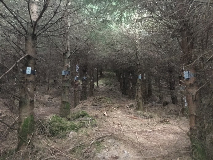
The proposed solution consists of a network of sensorised dendrometers, which communicate via Low Power Wide Area Network (LPWAN) to a central gateway situated within 1-2 km of the forest plot. This gateway will communicate via satellite or GPRS network to Treemetrics’ central servers that makes the data available to the end user via the Forest HQ web platform. Forest HQ is a platform for forest management developed by Treemetrics that offers additional services, such as forest mapping and forest inventory data collected using different measurement methods. The implementation of the IoTrees data in this platform will allow the user to combine this data with EO datasets and alternative forest inventory data.
Key forest measurement parameters such as DBH and tree height growth will be more regularly collected and transferred to the cloud no matter where the location. The IoTrees gateway will be strategically positioned to ensure that the maximum level of coverage will be provided depending on local terrain and vegetation density constraints.
The IoTrees solution will provide a new level of forest monitoring and measurement by leveraging latest IoT technologies, LPWAN, Satcom and web based analysis tools. The system will deliver vital forest management data but in a more frequent and cost effective manner.
Space Added Value
Given the remote depopulated nature of forests it is typical that forests do not have any wireless network coverage. Satellite communication systems will provide access to the data regardless of the location of the forest measurement plots. The SatCom solution will overcome this problem and provide the necessary communication to the measurement sensors. The measured trees will be geo-localised ensuring that satellite and drone monitoring imagery can be coupled. This will result in improved micro and macro level analysis of the forest. The IoTrees dendrometers with the enabled LPWAN and SatCom solutions will be unique to the market.
Current Status
The IoTrees project is successfully completed.
The IoTrees project has met most of the following project objectives.
- Creation a new dendrometer that enables remote measurement of trees and transfer these measurements wireless with LPWAN-LoRA and Satellite communication.
- ForestHQ has been further developed to support the services created by IoTrees and offer an integrated tool with forest monitoring capabilities.
- The combination of the IoTrees data with UAV/LIDAR to perform a remote forest inventory based on single tree delineation has resulted in an added value to the IoTrees project that has been highly recognised by the end users.
- The IoTrees Pilot has been very helpful to proof the reliability of the IoTrees system and the communication aspect of the solution.
During the pilot phase we found some standing issues to be improved before the commercial phase, such as
- Replace the device antenna and anchor to make it more weather resistant.
- Replace the wire around the tree with a metal band.
- Improvements in the duration of the device battery.
Before launching the IoTrees solution to the market, it is important to solve the standing issues to improve the system reliably in the forest conditions. Treemetrics is hoping to solve these issues in the coming year, along with a more commercial focused improvements to make the system less costly, easier to setup and more user friendly.


