

Objectives of the service
Looking at RSF Krakow (pilot RSF) in particular, it appears that neither service solutions nor a dedicated platform allowing the access and exchange of produced analyses from EO and GNSS data across multiple directorial levels (users) are used there. Presently, only aerial imagery for a very few number of tasks, mostly focused on visualisation purposes, without advanced data analysis techniques (value-added services) are being implemented by them. Since Poland was incorporated into ESA’s structure, knowledge of the benefits flowing from the possible solutions mentioned above has become more common and the State Forests has begun to look at opportunities to implement these solutions, which proves that their awareness has been raised. Thus, the IWBSF project is a perfect example of promoting integrated EO and GNSS technologies that highlight the benefits of such solutions.
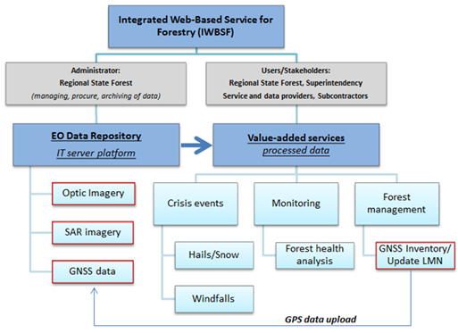
The design and implementation of the IWBSF service offers its users a reach access to analytic tools, processed and gathered information leveraged from EO and GNSS assets. Developed services provide forestry employees with the ability to make advanced analysis and download essential forestry analysis information in order to support required tasks for effective forest management.
Users and their needs
Users require EO and GNSS products and information to be available via Internet services. This enables them to display, download and edit produced analyses, as well as to integrate GNSS measurements with EO observations and export or share via services data for distribution in a quick and efficient way. Therefore, the functionality of the service embrace:
- Analytic section – this main component of the service covers advanced analytic tools and tailored algorithms, all published produced analyses and information (GIS layers) based on EO imagery (monitoring, crisis events, etc.). The layers are available for all authorized and interested permitted users also with the possibility to download onto mobile GPS equipment. The layers integrated with GPS mobile equipment can be used by final users to conduct mandatory forestry tasks;
- Data repository – this section contains all EO/GNSS archived data collected by the administrator of the service. Volume of data exceeds several hundred of gigabytes and still growing.
- The analytical toolbox - the set of advanced configurable tools to make or support classification, change detection analysis and acquire information about the change in forest volume;
- Standard tools (display, zoom, pan, extend, measurement of distance and area, search, information about the metadata, etc.);
- Edit tools (create new coverage, modify the band combination of EO images, etc.);
- Integration and sharing data with other systems through OGC standards (WMS, WFS, WMTS, WCS);
- Export and import functionality (map to .shp print map, GeoPDF, tables, and GNSS data); Service exchange tools to support and update field measurements from GPS mobile equipment (GNSS elements).
The target users are from Poland State Forests
Service/ system concept
Fig. 5 The Crisis events (windfall) in the superintendence of Krościenko (RDLP Krakow) has place in May 2016. The area of 13 840 ha has been affected. The aim of the feasibility study is the development of an end-to-end service to provide access to value-added information for forestry users. An integrate part of the service is necessary to build the dedicated IT infrastructure as a server platform with data repository of Earth Observation (EO) imagery and GNSS elements. The idea of the IWBSF is to promote efficient and widespread use of EO and GNSS elements through published services including outputs of produced analyses from forestry case studies, information distribution, inventory uploading, resource management and archival functions.
The end-to-end service provides access to case studies (analysis) which contain value-added information based on EO/GNSS elements. The pilot project embraces three (3) most important aspects for the forestry in Krakow, namely: Crisis Events (Hail or snowfall and windfalls), Forest Monitoring (forest health analysis and pest control), and Forest Management Plans (GNSS field inventories for updating Forest Digital Maps/LMN). The project concentrates on examples for each of those case studies.
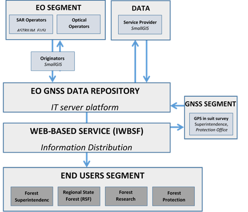
GNSS and EO data (SAR, optical, aerial images and GPS field inventory) from an up-to-date collection and archives from the Regional State Forest, superintendence and all collaborative bodies are stored and shared on the IT server platform.
During the feasibility study phase the prototype of the service has been developed.
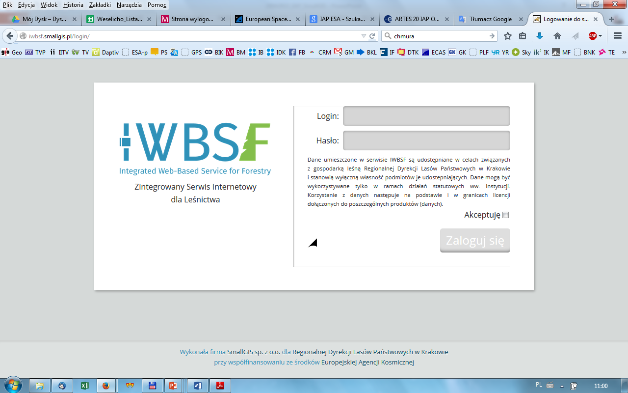
The login interface to the IWBSF.
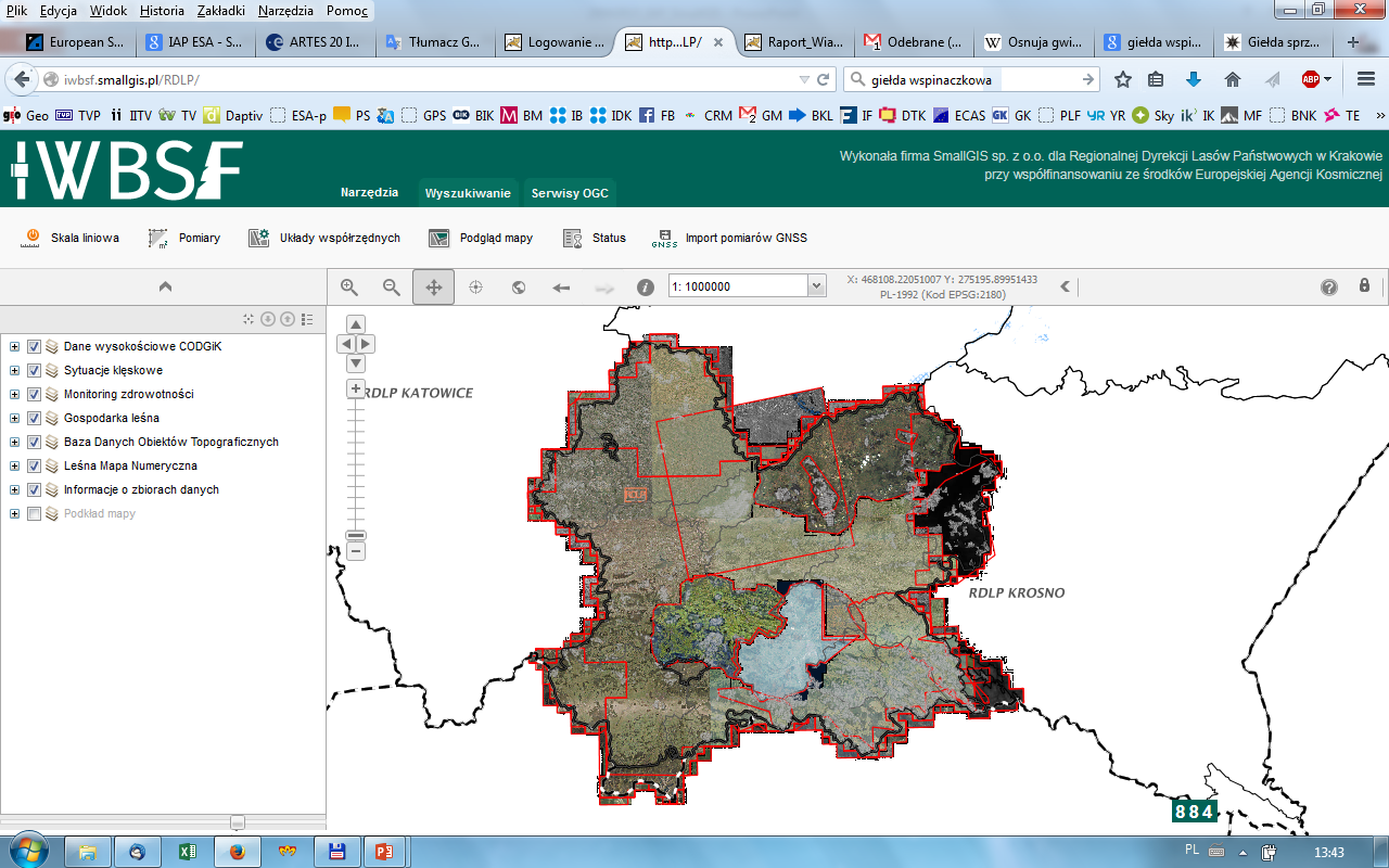
The IWBSF prototype service developed during the Feasibility Study.
Space Added Value
Fig. 5 The Crisis events (windfall) in the superintendence of Krościenko (RDLP Krakow) has place in May 2016. The area of 13 840 ha has been affected. Solution is based on two (2) main components: the end-to-end service containing case studies on how to use EO/GNSS elements for forestry needs and the IT server platform such as data repository storing and sharing that is all the data produced and collected by the Administrator of the service.
The development methodology for the proposed IWBSF focuses on providing a full case study of using EO and GNSS elements during specific situations happening within forests like crisis events or monitoring tasks. Other complementary and necessary tasks will be the creation of an EO and GNSS data repository and a web-based interface offering users access to processed data via value-added services tailored to support forestry tasks. This server platform is based on open source solutions such as: PostgreSQL, Geoserver, Open layers, OGC standards (WMS, WMTS, WFS and WCS). The methodology of services with remote sensing technologies are applied, focusing especially on: OBIA, change detection, complex index of vegetation, GNSS field survey, fusion approach (integration of information from different data sources) and fuzzy logic e.t.c.
Current Status
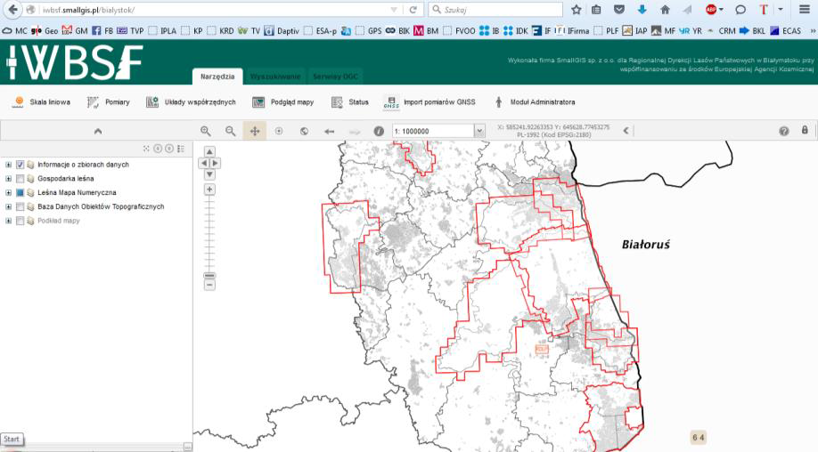
The WP5.1 has been finished and the adoption of the service for the new users (RDLP Szczecin and Białystok) has been implemented.
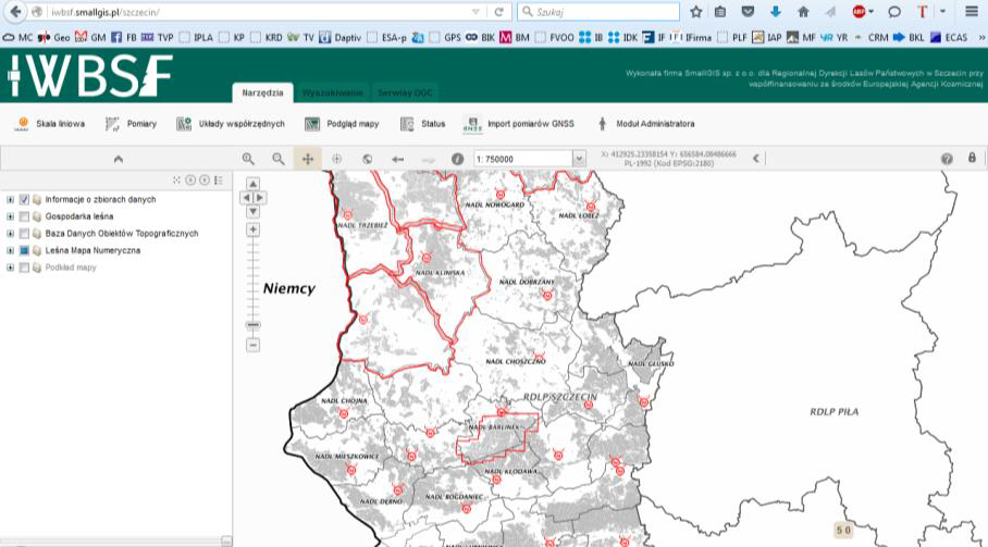
Fig. 1 The adopted service for the Szczecin RSF
During the demonstration phase, 7 events has been provided like for:
- RDLP Krakow: 4 events
- RDLP Szczecin: 3 events
- RDLP Białystok: 3 events
Below figures 3,4,5 and 6 presents the service activation:
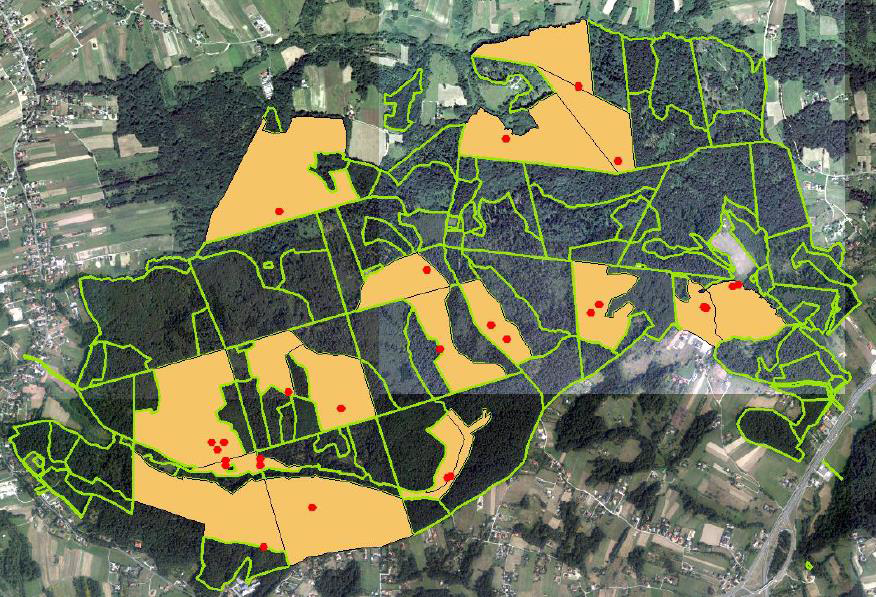
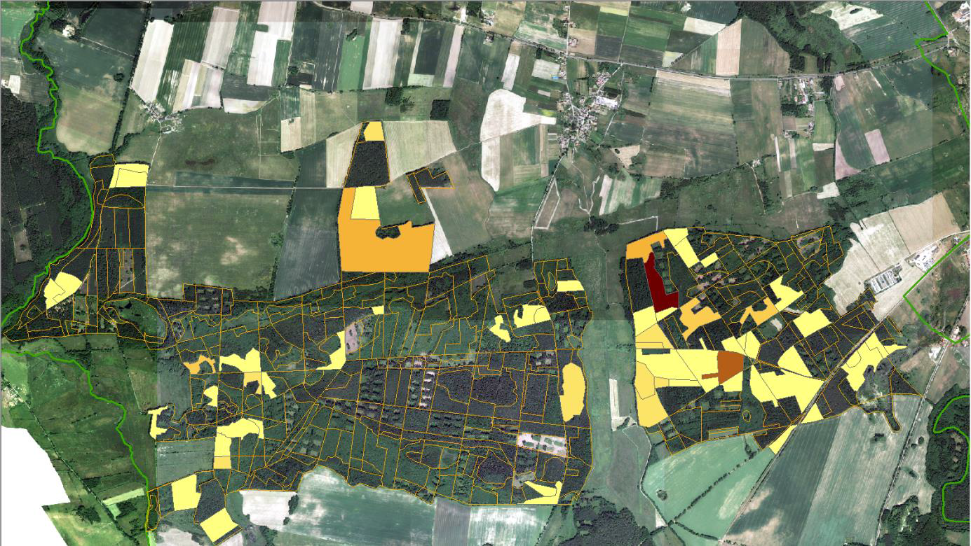
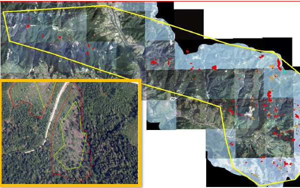
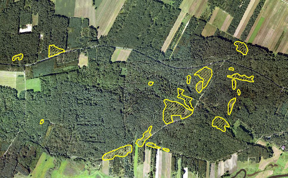
Fig. 6 In June 2016 the huge thunderstorm was damaged a thousands of trees in Dojlidy superintendence (RDLP Białystok). Almost 1100 ha of area has been affected of this crisis event. The analysis and identification has been provided to the foresters from this event.
In October the demonstration phase of the IWBSF project has been finished.
SmallGIS invites interested parties to cooperate in the construction of analytical systems using remote sensing technologies.