Objectives of the service

The development of new technologies and services in decommissioning and environmental management will be crucial in the coming years. The decommissioning activities need to increasingly consider space-based applications for a remote management.
KSAT DECOM will help decommissioning industry and operators in offshore Oil & Gas and Wind farms to achieve a safer methods of execution, reduce costs and, of course, monitor the environmental impacts that these activities will have in the ocean and the fishing industry.
KSAT DECOM will help decommissioning sector with:
- NRT SAR-based oil spill detection service
- Designing an optimal program in terms of revisit time, resolution and information to proactively detect oil spills and vessels.
- Exploring the fusion of its current services with additional satellite data to detect methane emissions.
This approach is an unprecedent concept where different capabilities will be put together for the decommissioning sector.
Users and their needs
KSAT DECOM will target two types of users; contractors and regulatory authorities. Both agree that the monitoring of environmental impact of the decommissioning activities is on their priorities so a good understanding of what is happening before, during and after of the works will be crucial.
The main needs identified are:
- Monitoring of the activities around the offshore platforms such as vessels or equipment.
- Rapid detection of oil spills during and after decommissioning activities for the mitigation of the pollution.
- Optimization of the decommissioning activities by reduce the costs.
The main challenges are:
- Thinking ahead how the KSAT DECOM activities can be optimally managed in terms of operational effectiveness, cost -efficiency and safety.
- Exploring the fusion of additional ancillary data sources to the core KSAT services such as the use of GHGSat assets to monitor methane emissions.
- Convincing decision makers on the actual added value of KSAT DECOM service should take into consideration.
In this Feasibility Study we mainly focus on the North Sea but also Thailand, Australia and Angola.
Service/ system concept
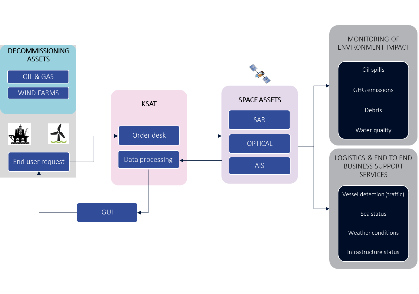
KSAT DECOM will be a space-based service that provides with high accurate vessels position and oil spills monitoring around the decommissioned platforms plus overall environmental monitoring before, during and after the activities.
Users will access the services through an interface tool that will offer agile and easy overview of the activities and phenomenon around their platforms of interest.
This service will combine different KSAT Near-Real Time services with new to be developed for supporting decommissioning activities.
Moreover, together with Kongsberg Maritime and Kongsberg Digital, we will explore the creation of 3D mapping to provide an optimum level of situational awareness.

Space Added Value
The following list provides the space assets that are intended to be used for the proof-of-concept of this feasibility study:
- Sentinel-1: capacity to cover wide areas makes it ideal for maritime applications. SAR images are extremely operational due to their capacity to acquire images immediately and independent of good light conditions and cloud-free skies. It has proven to be cost-effective compared to other solutions (Ground-Based radar, thermal imaging, etc.).
- Sentinel-2: constellation of optical satellites that will provide imaging opportunities over land and water with repeating image collections every 6-12 days. This constellation with its 12 spectral bands, high resolution as well as wide swath allows for mapping of a wide range of features.
- Sentinel-3: provides daily imaging over an impressive 1,270km swath focused particularly on ocean colour. Sentinel-3 is ideal to support maritime applications including oil spill detection.
- Sentinel-5P: first Copernicus mission dedicated to monitoring the atmosphere. Its main objective is to perform atmospheric measurements with high repeat to be used for air quality, ozone UV radiation, etc. and as such is ideal for wide area monitoring of emissions, some of which can be associated with oil and gas activities and during decommissioning activities.
- RADARSAT-2: SAR satellite with different beam modes for normal sea-state conditions.
- GHGSat Constellation: it has been designed specifically to quantify methane concentration and is therefore an ideal method for monitoring methane emissions form oil and gas operations as much as for monitoring the environment.
- Satellite-Based AIS: Real Time delivery of AIS data is of paramount importance in correlating oil spills with the responsible polluting vessel.
- High performance distributed Ground Station Systems for operational earth observation services, delivery of data in Near-Real-Time is critical to improve the response capabilities of the end users.
- High speed satellite communications systems.
- GPS.
Current Status
KSAT conducted different interviews and surveys with key operators and regulators to understand the complexities of the decommissioning activities, concerns in the sector and technology gaps that need to be ready for the coming 10-20 years where the assets will be decommissioned.
Moreover, KSAT participated in a virtual event where different users, operators and companies met to focus on all aspects of energy decommissioning - oil & gas, renewables, circular economy, marine, salvage and nuclear - and provide tangible insight into the sector.
After Business Case Review and last phase of the feasibility study has been concluded, KSAT plans for a follow-on demonstration project.


