Objectives of the service
Landfills are among the largest sources of methane emissions, a greenhouse gas with a significantly higher global warming potential than carbon dioxide. Accurate estimation of these emissions is critical for policymakers, regulators, and waste operators to develop effective mitigation strategies. However, current methods for estimating landfill methane emissions are often inaccurate, leading to underreporting and inadequate regulatory measures.
Kanadevia Inova (formerly Hitachi Zosen Inova), in collaboration with GHGSat, has developed Methane Monitor, a satellite-based service that provides more accurate landfill methane emission estimates. This service combines high-resolution satellite observations with on-ground tracer gas correlation measurements to account for daily and seasonal variations. By integrating these data sources, Landfill Methane Monitor offers a more reliable annual emission estimate compared to traditional extrapolation methods.
The objective of this project, co-funded by the European Space Agency (ESA) Kickstart program, was to develop and validate the methodology behind Landfill Methane Monitor. Over six months, the project designed a framework to improve emission accuracy, enhance regulatory compliance, and support a transition from landfilling to lower-emission waste-to-energy alternatives. This methodology will now be tested in a full-scale study, with the goal of enabling better decision-making for waste management and climate action.
Users and their needs
The primary target users of this service include landfill operators, municipalities, policymakers, and regulatory enforcers focused on managing methane emissions from landfills. These users are concerned with accurately assessing methane emissions to comply with environmental regulations and reduce their greenhouse gas (GHG) footprint. The key user needs include:
-
Accurate methane emissions estimation : Current methods are often imprecise, leading to over- or under-reporting of emissions.
-
Seasonal and daily emission profiles : Users need detailed data on emission fluctuations over time for better long-term planning and mitigation strategies.
-
Regulatory compliance : Users need robust, scientifically validated data to meet national and international GHG reporting requirements.
-
Integration of satellite and on-ground data : There is a need for a comprehensive solution that combines remote satellite monitoring with ground-based measurements for higher accuracy.
Challenges:
-
Ensuring consistent, reliable data collection across various landfill types and locations.
-
Overcoming the limitations of satellite observation during night-time or low-light conditions.
Targeted Countries: The service is initially targeting landfill operators and municipalities in Europe , with potential for broader application in other regions globally in the future.
Service/ system concept
This service provides users with accurate, detailed estimates of methane emissions from landfills by integrating satellite-based observations with on-ground measurements. The key functionalities include:
-
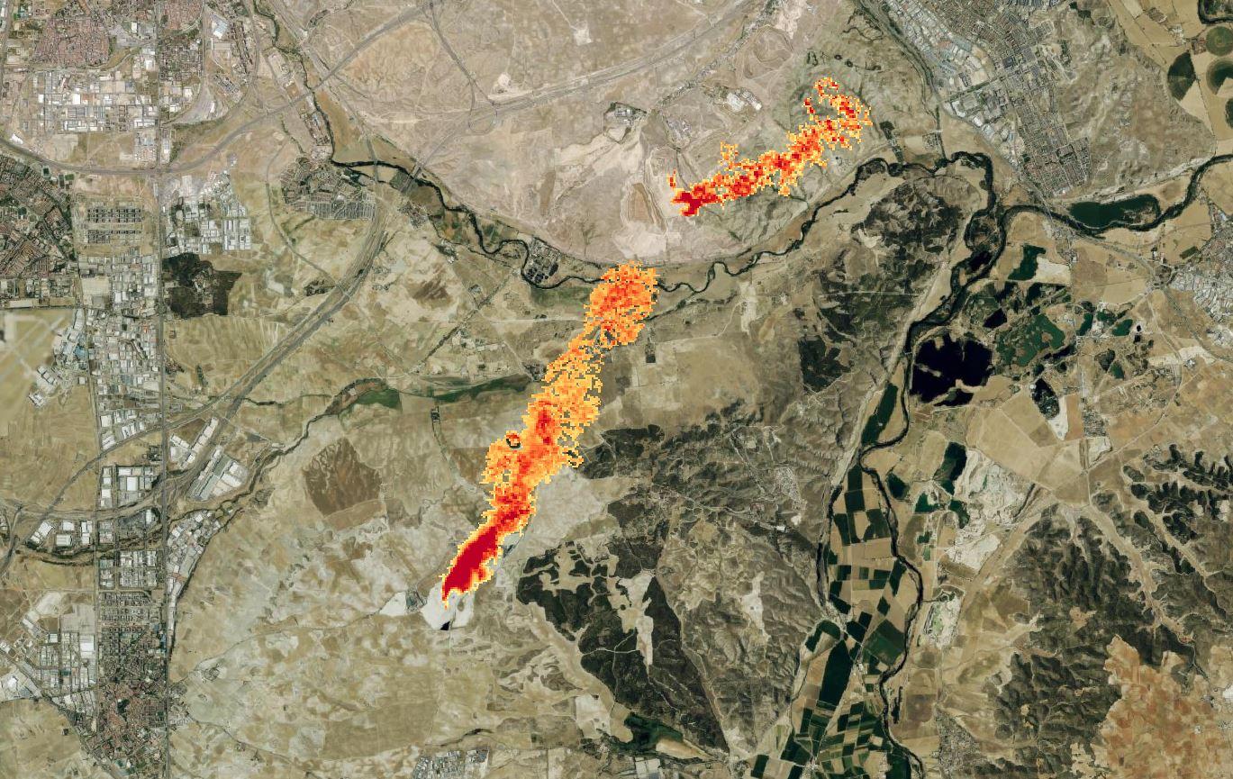
Satellite methane detection : Regular satellite observations of landfills throughout the year, accounting for seasonal variations in emissions.
-
Ground measurement integration : Use of tracer gas correlation techniques on-site to gather additional data, especially during night-time or low-light conditions when satellite observations are not possible.
-
Emission profiling : Creation of a daily emission profile, accounting for both time-of-day and seasonal variations, to improve the accuracy of emissions estimates.
-
Annual emissions estimate : Extrapolation of multiple daily estimates into a comprehensive annual emission profile, which is significantly more precise than conventional methods.
-
Real-time data processing : Wind condition data and other environmental factors are integrated into the system to fine-tune emission estimates.
Upon deployment, users will have access to precise, time-series methane emissions data, which can support regulatory reporting, policy-making, and more effective landfill management strategies aimed at reducing GHG emissions.
Our service helps landfill operators, municipalities, and environmental agencies measure methane emissions more accurately. Methane is a harmful gas that leaks from landfills, and it's much worse for the environment than carbon dioxide.
To track these emissions, we use a combination of two methods:
-
Satellites : We use satellites to regularly monitor landfills from space. These satellites can detect methane, but only during the day when there is enough light.
-
On-the-ground measurements : When satellites can't measure emissions at night or during low light, we send teams to the landfill to take measurements on the ground. This is done using special equipment that tracks methane more precisely.
By combining both methods, we get a clear picture of how much methane is being released, at different times of the day and throughout the year. This helps us create an accurate estimate of the total methane emissions from the landfill over the entire year, which is much more reliable than current methods.
The data we provide can help landfill operators and governments reduce emissions and make better decisions for the environment.
Space Added Value
Our service leverages high resolution methane monitoring satellites, that employ advanced spectroscopy technology to detect methane emissions from landfills. By using satellite data, we gain the ability to monitor landfills remotely, providing a significant advantage over traditional methods.
The key added value of using space assets is:
-
Wide coverage : Satellites can monitor landfills from space, even in remote or hard-to-access locations, which would be challenging or impossible with ground-based methods alone.
-
Frequent and consistent data : The satellite provides regular, timely observations that account for seasonal variations in methane emissions, offering a more comprehensive understanding than traditional methods that may be limited by sporadic ground measurements.
-
Real-time monitoring : With satellite data, emissions can be tracked in near-real time, enabling faster responses to potential methane leaks or regulatory concerns.
-
Complementary to on-the-ground measurements : Combining satellite observations with on-site ground measurements (especially at night) allows for a more accurate and complete emissions profile, addressing the limitations of both methods when used individually.
This combination of space-based and ground-based data gives us a powerful tool for achieving more accurate and reliable methane emissions estimates.
Current Status
Over the past six months, we have successfully developed the methodology for accurate methane emissions estimation, integrating satellite data with ground-based measurements. This was achieved through expert sessions with university researchers, a comprehensive literature review, and collaboration with GHGSat. The methodology accounts for both seasonal and daily methane variations to improve emission estimates.
Currently, we are finalizing the ESA Kickstart project. We are also preparing for a full-scale, one-year pilot test scheduled to begin in early 2026. This pilot will involve testing the developed methodology on multiple landfills across Europe to validate and refine the service before its wider deployment.