Objectives of the service
Use a bold image to start your webpage. It can be a photo or an infographic like this. Remember that you project webpage can be a powerful marketing tool.

Describe in less than 200 words the objectives of the service, i.e. what are the key problems of the users, what is the solution you intend to provide and how will you provide it. Please describe also the objectives of the activity (Study or Project). Avoid the use of phrases like “The objective is to investigate the technical feasibility and economic viability...”. Restrict the use of acronyms and make sure there are spelled out at first occurrence.
In the aftermath of natural disasters or other crisis events, rapid and accurate assessment of building damage is critical to the effective delivery of aid and to ensure the safety of affected populations. The aim of the MASAI project is to support national and international organizations, such as the Italian Red Cross Association (CRI), project end-user, in timely and efficient relief operations. CRI needs tools that provide information on the damaged area and a rapid and extensive damage assessment to better manage the many emergencies occurring around the world and to plan its intervention, coordinating with other sister organizations.
Our solution meets the needs of users and, thanks to the integration of SAR (Synthetic Aperture Radar) and VHR (Very High Resolution) optical remote sensing techniques, enables a more complete, efficient and accurate assessment of building structures. The ability to quickly estimate the affected area, the involved population and assess building damage, while avoiding on-site inspections, can help prioritize relief and aid, ensuring that the most critical needs are addressed first.
Users and their needs
The MASAI system has been tested by the Italian Red Cross Association (CRI) involved in the project as end-user. CRI is an independent neutral organisation that provides protection and humanitarian assistance to victims of armed conflicts and other situations of violence by providing facilities, health services and assistance to the population, and supports communities before, during and after emergencies. It consists of five operational units: Emergencies, Special Relief and Preparedness, Migration, Health Services and International Emergencies.
Main user needs are:
-
having a georeferenced and queryable information to assess the extent of the humanitarian crisis under consideration
-
having a first rapid analysis of the area in terms of the level of damage to buildings on a coarse scale (through SAR images analysis)
-
having a second more detailed analysis of the area at high resolution on buildings damaged and people involved
-
assessing the evolution of the humanitarian crisis making available new radar and VHR elaborations on the defined areas.
The challenge MASAI faces is to make the workflow of automatic damage appraisal as efficient and effective as possible, both in terms of timing and performance.
Service/ system concept

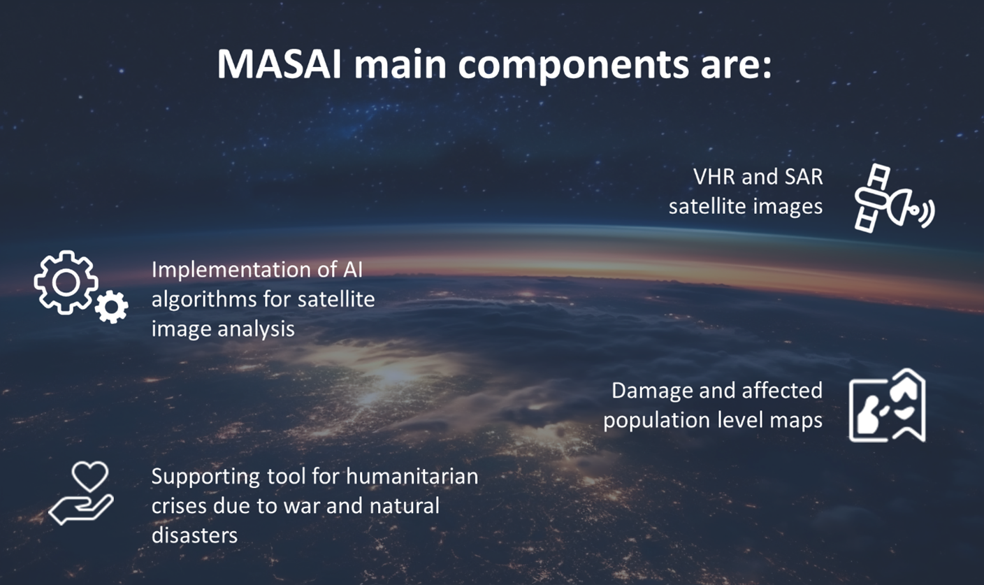
MASAI takes advantage of advanced technologies such as the use of satellite-based SAR, VHR through AI algorithms which have proven to be valuable tools in humanitarian crisis response.
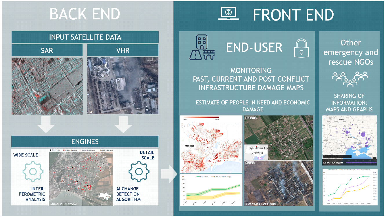
MASAI web platform consists of the following elements:
Front-end (FE): MASAI Web platform (FE) graphical user interface is map-centric (WebGIS focussed) so that all information is easily accessed and recognized on a map. The platform allows the:
-
Identification of damaged areas during the humanitarian crisis and post-conflict, thanks to the comparison with images of the pre-emergency
-
Assessment of damaged buildings and infrastructures
-
Appraisal of the increase trend in damage in the time interval among subsequent satellite images
-
Estimation of the number of potential displaced people in need of assistance
-
Estimation of the economic damage
-
Map annotation tools (e.g. local information, images …)
-
Integration with existing tool (e.g. WMS services …).
Back-end (BE): represents the whole set of processes, DBs and pre/post-processors that make up the two "engines" of the system: (1) the interferometric analysis on the wider scale and (2) the AI change detection algorithm on VHR at the higher scale.
Space Added Value
The space assets that MASAI uses are satellite earth observation (SatEO) in particular:
-
Sentinel-1 SAR satellite imagery from the programme Copernicus, which is characteristic by a medium resolution and revisit time of about six days;
-
Very-High-Resolution (VHR) satellite imagery, derived from commercial sensors (WorldView-2, WorldView-3, GeoEye and Pleaides), with an average resolution of about 50 cm.
Other technologies of interest for our solution are:
-
Implementation of an automatic AI algorithm that identifies the most damaged areas from VHR images.
-
Implementation of algorithms to identify and classify, through interferometric and SAR coherence analysis, the areas where infrastructure is most affected by damage.
MASAI could be widely used as a tool in damage assessment procedures during humanitarian crisis due to war and natural disasters and in any post-disaster reconstruction program. It will be developed to be easily adaptable to different contexts and types of emergencies that CRI manages. Moreover, the use of satellite SAR, VHR imaging and automatic AI tools in building damage assessment can significantly reduce the effort in terms of time, cost and safety respect to manual appraisal.
With respect to competitors MASAI combines the AI algorithm for interpretation imagery (both SAR and WHR) with operator’s photo interpretation and capabilities tailor-made to the needs of CRI.
Current Status
The project is started at the beginning of October 2023 and it is currently a contract extension is being asked for.


