

Objectives of the service
Every year, thousands of people drown due to delayed emergency response, lack of real-time hazard awareness, and poor connectivity at remote beaches. Many fatalities could be prevented if lifesaving information reached people at the right time.
MyCoast is tackling this challenge by developing satellite-enabled coastal safety beacons that provide near real-time hazard alerts, environmental monitoring, and emergency response support—even in areas with no mobile coverage. These beacons integrate artificial intelligence (AI) for rip current and swimmer detection, Global Navigation Satellite System Interferometric Reflectometry (GNSS-IR) for tidal and wave height monitoring, and a satellite-enabled emergency relay to ensure distress signals always reach responders. Satellite communications (Satcom) will provide a connectivity hotspot, allowing first responders to maintain secure communication even in remote locations.
Supported by the European Space Agency (ESA), this project brings together cutting-edge space technologies and lifesaving expertise to revolutionise coastal safety. The MyCoast KickStart activity is engaging both end-users and search and rescue organisations, governments, and environmental agencies to design a scalable solution that enhances emergency response, enables proactive public safety alerts, and provides critical environmental insights.
By bridging the gap between technology and lifesaving operations, MyCoast is laying the foundation for a globally scalable system that protects lives, informs decision-making, and ensures that no one is left without help when they need it most.
Users and their needs
The MyCoast service is designed for a broad range of users in the United Kingdom and Australia, with future expansion into other high-risk coastal regions. The key user communities and their needs include:
-
Search & Rescue Organisations
Users: Global search and rescue organisations who have a have a responsibility for public safety.
Needs:
Faster emergency response in remote or connectivity-challenged locations.
Reliable emergency distress relay via Global Navigation Satellite Systems (GNSS).
Near real-time situational awareness through AI hazard detection, GNSS-IR tidal monitoring, and IoT sensors. - Government & Environmental Agencies
Users: Environment Agencies, coastal councils, harbour authorities, climate monitoring bodies.
Needs:
Near real-time environmental data to improve water safety, pollution monitoring, and coastal management.
Satellite-enabled hazard mapping for better public safety decision-making.
Scalable digital infrastructure for safety monitoring at non-lifeguarded beaches. - General Public (Coastal Visitors & Water Users)
Users: Beachgoers, surfers, swimmers, divers, boaters, and tourists.
Needs:
Near real-time safety alerts (rip currents, pollution, extreme weather) via the MyCoast app and beachside digital displays.
Clear, location-specific hazard warnings before arriving at the coast.
Reliable emergency contact points, especially in remote areas with no mobile coverage.
Challenges for the Project
Ensuring low-power, high-performance satellite connectivity for continuous operation.
Securing regulatory approvals for emergency distress relays.
Optimising AI hazard detection to function effectively across diverse coastal conditions.
Driving user adoption across Search & Rescue Organisations and government agencies to ensure widespread implementation.
Service/ system concept
The MyCoast service provides lifesaving organisations, local authorities, and the public with near real-time coastal safety intelligence, environmental monitoring, and emergency communication.
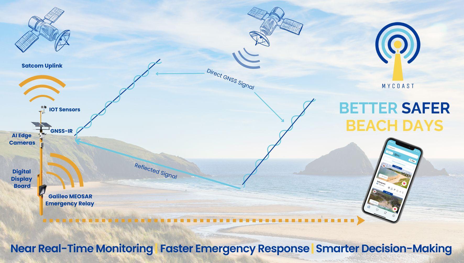
At the heart of the system are MyCoast Beacons, deployed at high-risk coastal locations. These beacons integrate GNSS-Interferometric Reflectometry (GNSS-IR) for local water level monitoring, AI-powered cameras for rip detection, and IoT sensors for weather tracking.
Data is processed on-site using edge computing to minimise bandwidth usage and is transmitted via Satellite Communications (Satcom) to ensure connectivity, even in remote locations. Emergency alerts use the Galileo MEOSAR distress system, allowing instant SOS signals to be relayed via GNSS satellites.
The MyCoast system provides three core capabilities:
-
Lifesaving Organisations receive AI-enhanced hazard detection, emergency alerts, and improved response coordination. Portal enables geofenced messaging, control over dynamic parameters.
-
Local Authorities & Environmental Agencies access continuous coastal monitoring data for decision-making and long-term safety planning.
-
The General Public benefits from personalised safety alerts, hazard warnings, and better coastal planning tools via the MyCoast app, websites, and public digital displays.
Through this integrated, space-enabled system, MyCoast ensures beach users and emergency responders have the right information at the right time to save lives.
Space Added Value
The MyCoast service leverages multiple space assets to enhance coastal safety, improve emergency response, and provide near real-time environmental monitoring in ways that existing terrestrial solutions cannot.
Satellite Communications (Satcom)
Unlike current emergency response beacons that rely on terrestrial 4G/5G networks, MyCoast integrates Satcom connectivity to provide a reliable, continuous data link in remote coastal areas. This ensures that lifesaving organisations can receive live hazard data, coordinate rescues, and access emergency alerts even where mobile networks are unavailable.
GNSS-Interferometric Reflectometry (GNSS-IR)
By repurposing signals from Global Navigation Satellite Systems (GNSS), MyCoast Beacons can monitor tidal levels, wave heights, and rip currents without requiring in-water sensors. This approach provides low-cost, real-time coastal monitoring, filling critical data gaps for search & rescue teams and policymakers.
Satellite-Enabled Emergency Relay
Unlike terrestrial-only emergency alert systems, MyCoast uses an international satellite-enabled distress signal relay to ensure SOS messages are instantly transmitted via GNSS satellites. This drastically improves rescue response times, particularly in locations where standard VHF radio or mobile networks are unreliable.
Why Space?
Unlike competitors that rely on fixed cameras, cellular networks, or manual reporting, MyCoast integrates space-based technologies to create a globally scalable, 24/7 coastal safety system. By combining Satcom and GNSS-enabled technologies, MyCoast ensures real-time situational awareness, reducing delays in emergency response and improving data accuracy for long-term coastal safety planning.
Current Status
The MyCoast KickStart activity is now complete, having successfully engaged over 100 stakeholders across the UK and Australia, including lifesaving organisations, coastal authorities, environmental agencies, and emergency responders. Additionally, over 600 active end-users of the MyCoast app contributed valuable insights into their safety information needs.
Key achievements include:
Comprehensive user engagement, with stakeholder forums and direct consultations validating key pain points in emergency response, hazard awareness, and connectivity.
-
Technical feasibility assessment confirming the added value of integrating Satcom, GNSS-IR, and satellite-enabled emergency relay into MyCoast Beacons.
-
Economic viability study demonstrating a scalable commercial model for deployment and long-term sustainability.
-
A fully defined 5–7 year Demonstration and Commercialisation Pathway, including trial sites, system architecture, and partnerships in both the UK and Australia.
With these milestones achieved, MyCoast is ready to advance into the Demonstration Project phase, where real-world trials will validate performance and pave the way for full-scale adoption.