Objectives of the service
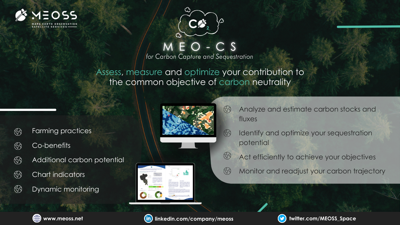
MEO-CS is a unique tool dedicated to the issue of biological carbon sequestration.
-
It relies on the contribution of satellite data (homogeneous, reliable, objective and updated data) to monitor and evaluate the trajectory of carbon capture, storage and sequestration on a territory.
-
It is a turnkey tool that is accessible to all (experts or not) and does not require any software or specific skills to grasp and understand the challenges of a territory in terms of carbon sequestration.
-
It is a generic tool that can be adapted to each new territory and allows end-users to focus on their core business of analysis and planning by proposing indicators adapted to the issue:
-
land cover and land use change ;
-
carbon stocks and fluxes ;
-
additional carbon potential per agricultural practice;
-
co-benefits; cost...
-
-
Designed and co-constructed with users to meet their operational needs: it enables the inventory, regular monitoring and final evaluation of the measures applied in terms of carbon sequestration
-
Cost control and guarantee of compliance with approved standards and procedures: there is no need for dedicated in-house resources to guarantee the reproducibility and sustainability of the solution and monitoring.
Users and their needs
The main users of the service are local authorities who are in charge of implementing and monitoring actions in the context of the national low carbon policy in order to respond to the common effort of carbon neutrality to the best of their abilities. Their needs can be summarised as follows:
-
Quantification of carbon stocks
-
Estimation of carbon flux between two dates
-
Estimation of the potential additional carbon stocks from agricultural practices
-
Identification and location of the co-benefits
-
Estimation of the additional cost of the agricultural practices for farmers
The first country targeted for the commercialisation of the service is France. The knowledge of the political context and needs allowed the tool to be customised to meet the needs of the country's users. Other European countries are being evaluated in order to deliver a customized service to the specific needs of the selected countries.
Service/ system concept
MOE-CS is dedicated to monitoring carbon stocks and fluxes related to land cover and land use / Land cover changes (LULC changes), based on both local annual estimates and land cover dynamics.
It provides spatial-temporal mapping estimates of the organic carbon sequestration capacity of forests and other land use classes (grasslands, crops, vineyards, orchards, wetlands and water surfaces, impervious areas, grassy and wooded artificial areas) over a given area.
To do this, the service relies on the contribution of satellite data, local databases and reference coefficients for the conversion into carbon equivalents drawn from known and recognised methods accessible free of charge for France from the ALDO tool
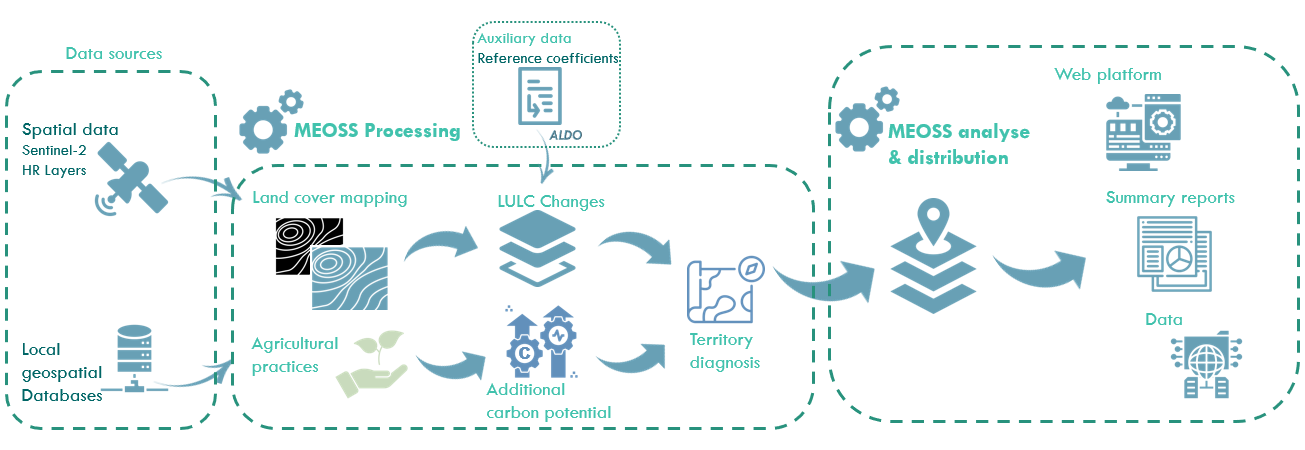
MOE-CS will be available in three formats:
-
Processed data in an interoperable format,
-
A synthetic report format and –
-
In the form of a cartographic web application allowing users to access a dynamic and territorialized diagnosis of carbon sequestration capacities. This information will be delivered through indicators, typically (i) carbon stocks (CS) based on land cover data (LC) and (ii) carbon fluxes (CF) based on land cover change data (LCC). (iii) additional potential generated by the implementation of agricultural practices that favour carbon sequestration.
Space Added Value
The delivery of MEO-CS service strongly relies on the long-term availability of free and open data from the EU Copernicus Programme (especially Sentinel-2 optical data) and on Copernicus LMS derived products (High Resolution Layers (HRL), Urban Atlas…).
Two satellite data sources have been identified for delivering the MEO-CS service:
The HRL data as first source: for providing information on 5 land cover classes (layers): (i) level of sealed soil (imperviousness), (ii) tree cover density and forest type, (iii) grasslands, (iv) soil moisture and water, and (v) small woody features. They are integrated for deriving simplified land cover maps with nomenclature matching the ALDO tool.
The Sentinel-2 data as second source: they can be directly integrated in MEO-CS for deriving land cover maps according to the simplified ALDO nomenclature; in this case, the application of an automated classification procedure is needed. This option requires local reference data sets to calibrate, assess and validate the classification models.
In addition to satellite data, regional and local reference (proxy) carbon sequestration estimates is needed for delivering high-quality products.
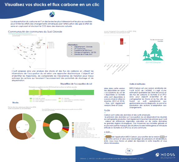
Current Status
At this stage, the spatialization of carbon stocks and fluxes and the derived indicators were tested with Corine Land Cover and regional land cover data. Some of the results are presented in the figures below.
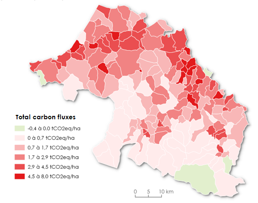 |
Total carbon fluxes per municipality related to land cover changes between 2009 and 2015 in the territory of Pays Basque & Seignanx, excluding forest biomass, in tCO2eq/hectare. Reference land cover data is the regional land cover. |
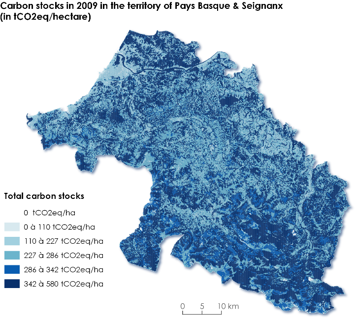 |
Carbon stocks in 2009 in the territory of Pays Basque & Seignanx, in tCO2eq/ha. Reference land cover data is the regional land cover. |
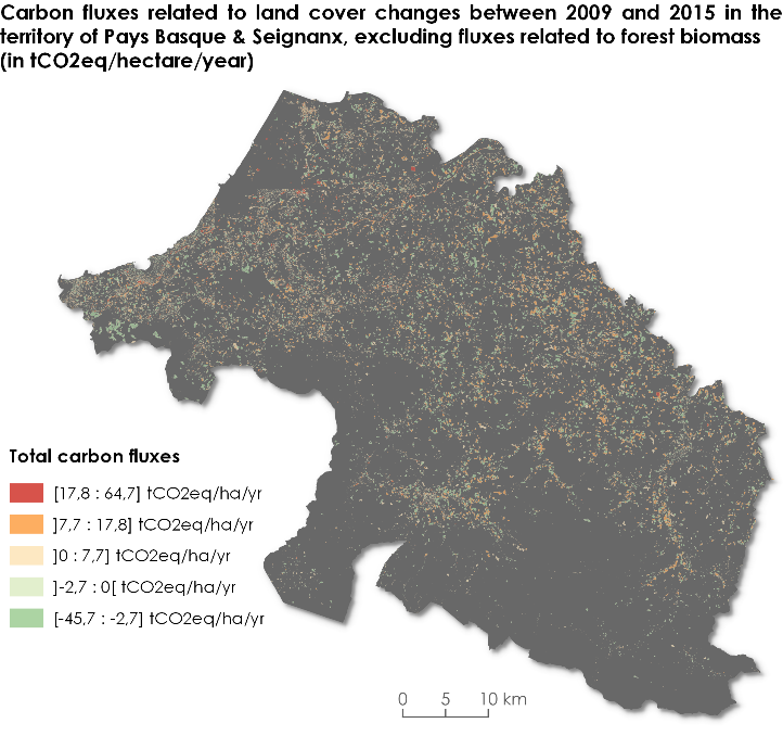 |
Carbon fluxes related to land cover changes between 2009 and 2015 in the territory of Pays Basque & Seignanx, excluding fluxes related to forest biomass, in tCO2eq/hectare/year. Reference land cover data is the regional land cover. |
The results are also available in the form of a summary report organised by municipality and gathering the main information and characteristics on land cover, carbon stocks and fluxes with a short analysis.