Objectives of the service
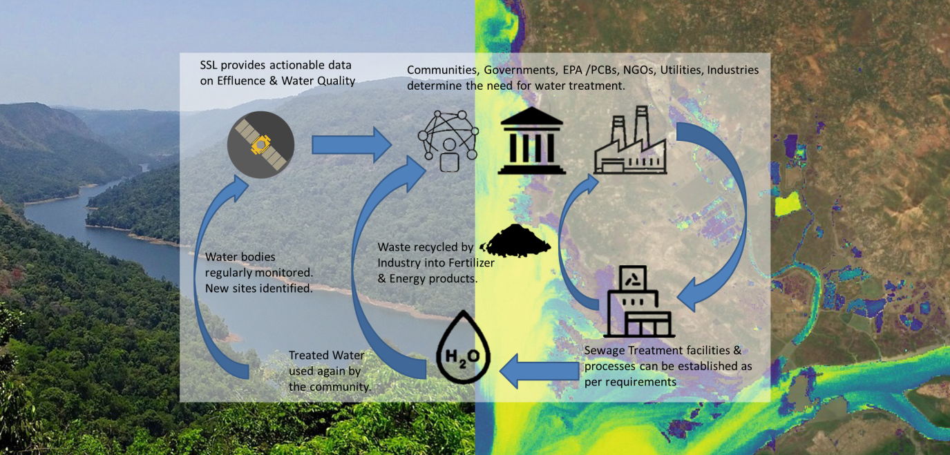
Satellite Earth observation data and artificial intelligence tools are used to monitor effluence and untreated sewage flow into rivers, lakes and reservoirs. As water becomes increasingly scarce, it has become important to manage this vital resource. The problems around accessing safe drinking water and sanitation facilities are also major concerns. To address these concerns, there is a need to reuse treated wastewater and prevent pollution of water sources.
Several studies show that there is a lack of wastewater treatment facilities and that pollution levels have increased in surface water. Additionally the EU Water Framework Directive has an aim to achieve at least ‘good ecological’ status for water resources of all member nations. Using our effluents & water quality monitoring process, water utilities and government agencies can effectively and efficiently detect untreated sewage and effluent discharge flowing into water resources. This process provides a low cost and effective means of monitoring water resources. Physical infrastructure like monitoring stations and equipment are not required, it allows for large scale and scope for monitoring. It also provides the ability to analyse data spatially that can help determine sources of pollution and help identify locations for
Users and their needs
The main target customer groups for the MERSAI service are Water Utilities (WU) and Environment Protection Agencies (EPA). Both these customer groups have a strong incentive and need to monitor water resources under their administration. This service will help WUs better monitor their sources of raw water i.e. lakes, rivers and reservoirs and help ensure safe supply to their customers. This service will allow EPAs to monitor sources and intensity of water pollution and take appropriate remediation and prevention actions.
Currently, these customer groups follow the traditional method of water quality assessments, i.e. collection and testing of physical water samples from various locations. The current challenge for the MERSAI project is to help integrate these two different approaches of physical assessment and remotely sensed assessments in a way that the customer gets the benefits of both processes.
The needs of the Customer groups may be summarised as follows:
- Cost effective & convenient method to monitor water quality
- Ability to monitor large water bodies
- Ability to identify source and intensity of pollutants
- Means to identify suitable locations for water treatment facilities
Currently the MERSAI pilot projects and services have been conducted in the United Kingdom & India.
Service/ system concept
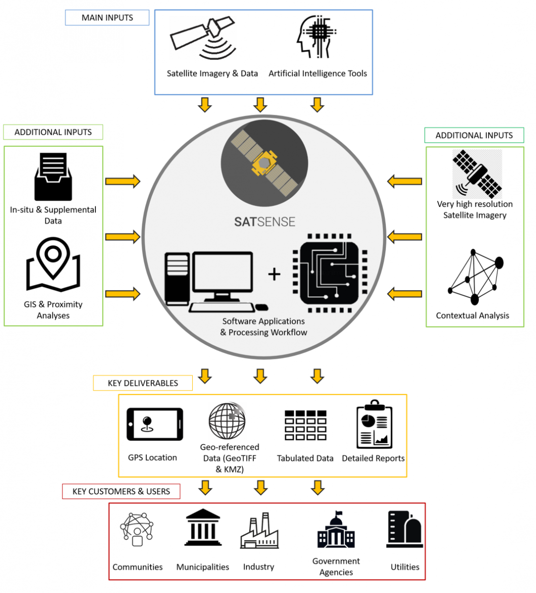
MERSAI uses satellite remote sensing data from multi-spectral sensors in the visible and infrared spectrum and a Neural Network processor to evaluate water quality characteristics like total suspended matter (TSM), colour dissolved organic matter (CDM), light penetration depth (Z90) and chlorophyll-a concentration (CHL). These water quality characteristics are spatially represented and customers may be provided service deliverables in the form of geo-referenced files (GeoTIFF, KMZ) which may be incorporated into their GIS platforms. Alternately, this information may also be provided in form of machine readable tabulated data and GPS co-ordinates indicating hot spots for on ground inspections. Additional geospatial analyses, such as proximity and contextual analyses, can be performed to identify sources and intensity of pollution, suitable locations for water and sewage treatment facilities and points for water intake. Detailed reports, with snapshots of satellite imagery and time series data, can also be provided as per requirements. The MERSAI service will allow users to monitor quality characteristics over vast expanses of water bodies quickly, conveniently and cost effectively. Allowing them to identify sources of pollution and ensure access to safe potable water.
Space Added Value
MERSAI uses Satellite Earth Observation (SatEO) multi-spectral optical data in the visible and infrared spectrums to assess Water Quality (WQ) characteristics. SatEO provides large amounts of high quality, standardised data from across the globe, with high spatial (10 m, nominal) and temporal resolutions (revisit times, up to 2-3 days). Use of spectral data beyond the visible spectrum provides the ability to detect phenomenon that would otherwise not be visible to the human eye. Use of spatial data with wide coverage provides the ability to monitor remote and hard to access locations, and also provides a comprehensive picture of on-ground situations. Monitoring WQ parameters using SatEO data is a big change from the traditional methods of WQ assessments, which involves physically collecting water samples and testing in the laboratory. While physical testing has its own benefits, it can be expensive, time consuming and labour intensive. It is also point data and therefore not often representative of the entire water body’s characteristics and can cause outlier errors. A standalone SatEO WQ assessment service can provide unique value and actionable information to customers and users, while integrating the SatEO WQ assessment with traditional methods can help users get benefits of both approaches.
Current Status
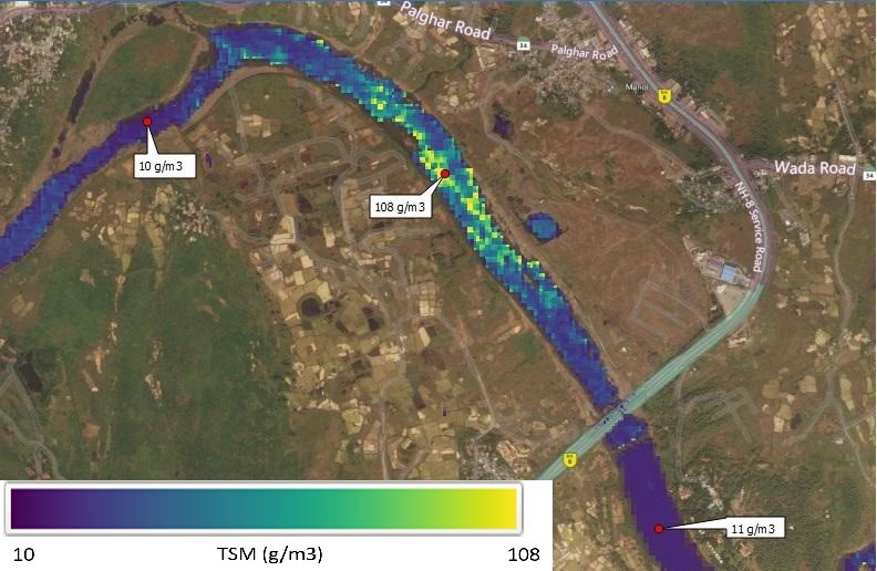
Image 1: Assessing Water Quality parameters (TSM) in the Vaitarna River, Western India.
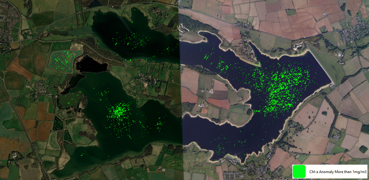
Image 2: Monitoring Algal Blooms in Rutland Reservoir, United Kingdom.
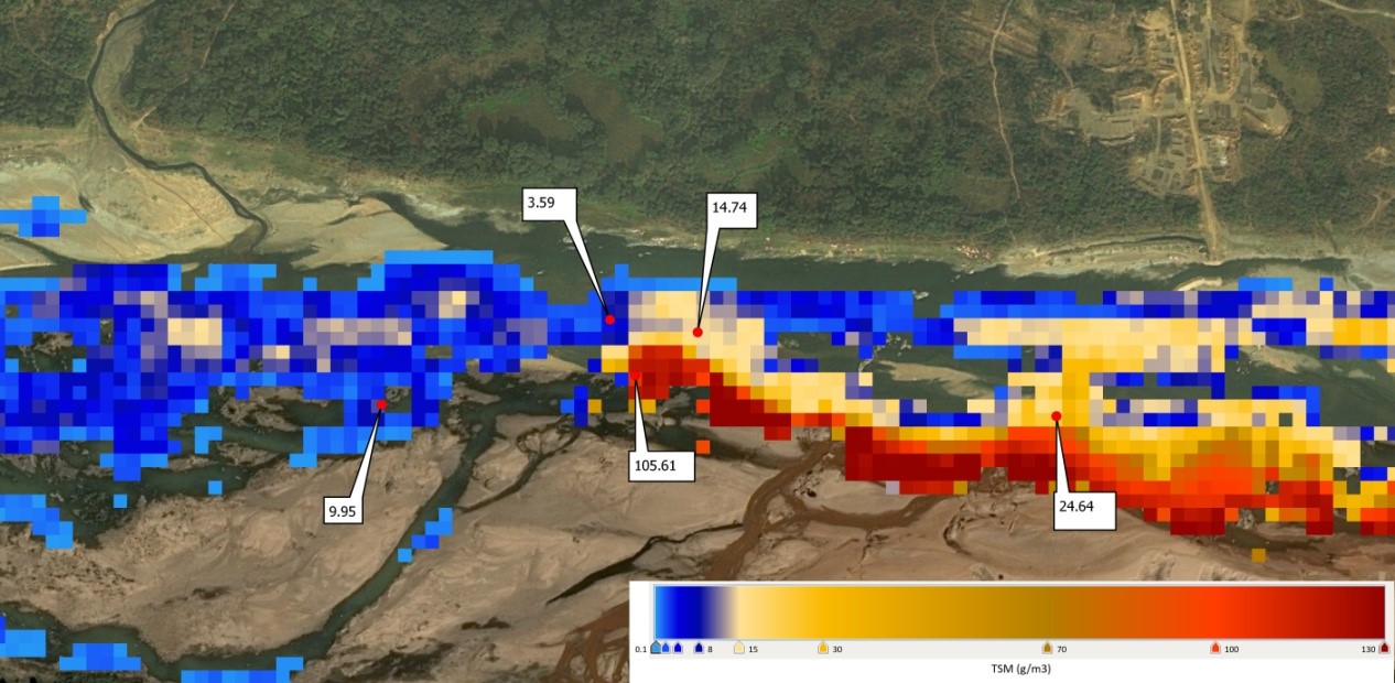
Image 3 : Detecting sources of Pollution in the Damodar River, Jharkhand, India
More than half a dozen MERSAI pilot projects have been initiated across the UK and India. The service has been demonstrated to two major Water Utilities in UK with positive feedback and to five Environmental Protection Agencies in India where Request for Proposals were received. Agreements for providing the service have been reached with a major Steel Manufacturer having operations in the UK and India and a global consulting firm. The Steel Manufacturer would like to monitor the water resources in their integrated township, and these include lakes, rivers and reservoirs. The global consulting firm has a vision of utilising this service to cater to Government clients, Smart City projects and possibly build an open data portal to facilitate transparency and good governance. Several pilot projects have fulfilled user requirements, vital feedback from current users is continuously being used to provide more comprehensive, value added services to exceed customer requirements.


