Objectives of the service
Coastal and riverine settlements are ever more affected by extreme climate conditions. Increasing their resilience through maintaining healthy ecosystems – like beaches, dunes or controlled flood plains – and man-made structures – like seawalls or dikes – or securing their re-establishment in case of damage or destruction are essential to preserve economic, social and environmental functionality at the hinterland. However, assessing the condition of such ecosystems and structures through conventional monitoring methods is time-consuming and costly. Furthermore, the time intervals between data collection and analysis are long. Moreover, data is collected from different sources and stored and visualised in different systems, resulting in a lack of consistency in data analysis and quality control. On the whole, this is not only preventing authorities from acting fast in order to avoid or mitigate risks in coastal and riverine settlements, but also presenting significant risk in the utilities and construction industries, as well as the financial sector.
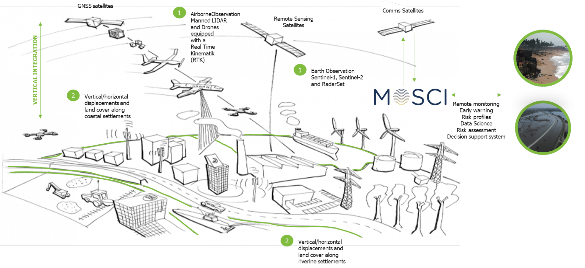
MoSCI - ECOSPACE is a suite of web-based subscription services for storage, processing, visualisation and analysis of earth and airborne observation datasets - spanning over a range of spatial and temporal resolutions, with capacity to deliver meaningful information for overseeing and managing risks to critical infrastructure (CI) in coastal and riverine settlements and be an early-warning decision support system.
Users and their needs
MoSCI - ECOSPACE is segmented into three customer segments, each of which with specific needs:
- Public water authorities, with different mandates and responsibilities for managing coastal or riverine areas and resources. What customers in this segment need is “to improve what we do and have now” and “be able to act faster” in emergency situations, without increasing – or even decreasing – the time, energy and money committed. These customers look for a single automating post-processing tool that can pull spatial-temporal data from multiple sources and run analysis on it together [geographical area: several tens or even hundreds of kilometres]
- Utilities, Contractors and Engineering Consultants. What customers in this segment need is a low-cost tool to make quick high-level assessments of erosion and flooding risks to the assets they own or have engineered/built. These customers also need to perform complex scenario analysis including stress tests to specific risk drivers – e.g. climate change – based on complex modelling and benchmarking against performance targets. [geographical area: few kilometres]
- International Financial Institutions and Insurance brokers. Individual customers in this segment also need a low-cost tool to make quick high-level assessments of erosion and flooding risks and to perform complex scenario analysis in order to reduce risk in investments and insurance premiums. [geographical area: several tens or even hundreds of kilometres or few kilometres (asset-level)]
The MoSCI - ECOSPACE service tool has a global market potential. However, the initial target markets of MoSCI - ECOSPACE are Belgium, France and West Africa.
Service/ system concept
Understanding how extreme climate conditions translate to impacts to people, CI and natural systems is critical in order to prepare for, and strive to reduce, the magnitude of damages from storms and floods. Lack of knowledge and evidence-base short after a specific event are preventing authorities to take appropriate actions to avoid or mitigate risks in coastal and riverine settlements and is presenting significant risk in the utilities and construction industries, as well as the financial sector.
MoSCI - ECOSPACE consists of independent service modules – e.g. ‘topography’ (horizontal displacement) and ‘subsidence’ (vertical displacement), which translate user needs into specific service benefits. The suite of services create value to customers by (1) integrating earth and airborne observation datasets – spanning over a range of spatial and temporal resolutions – into a centralised web-based tool; (2) using standardised protocols for data storage, extraction, processing, analysis and (raw) data quality controlling; and (3) translating datasets into meaningful information for overseeing and managing risks to critical infrastructure in coastal and riverine settlements.

Space Added Value
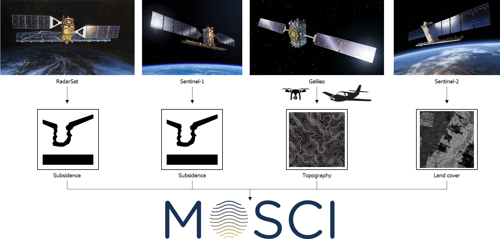
The service is combining several space assets and merging the derived products with other products that are already used by customers. The first space assets are Sentinel-1 and RadarSAT which are used to derive subsidence information based on inSAR (Interferometric Synthetic Aperture Radar). The second space asset is Galileo which combined with drones provides crucial information for the correct positioning of the drone data and the derived topography information. All these data can provide information on e.g. the stability of CI and can be combined with existing LIDAR datasets obtained from manned airborne acquisitions. Finally, land cover maps are derived from Sentinel-2 and then used to derive exposure information along coastal and riverine settlements for damage and risk assessments.
Integrating the space assets allows faster assessments of the condition of ecosystems and protection structure to CI and, consequently, to act faster and better in case of damage or destruction.

Current Status
MoSCI - ECOSPACE Feasibility Study is completed. It consisted of three components: technical feasibility assessment; service prototyping; and business model and plan. During the technical feasibility an evaluation on whether the suite services could be delivered at the required spatial and temporal resolutions and accuracy was made. Still within the technical feasibility, the TRL level and the existence of operational service providers for the assets was evaluated, together with a cost-benefit analysis of each of the potential assets. The prototyping has been carried out using Design Thinking. In parallel, both the business model and the business plan of the suite of services have been developed; from which is concluded that a compelling a business case can be created around MoSCI – ECOSPACE.
Prime Contractor(s)
Subcontractor(s)


