

Objectives of the service
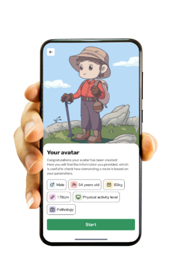
The increasing number of people participating in outdoor activities such as hiking has led to a rise in accidents and rescue calls in recent years. Regarding the characteristics of rescued individuals, 36% do not meet the recommended level of regular physical activity, around half are overweight, and 39% have a chronic disease. The MOVE in SPACE project aims at the creation of a software to improve the safety and personalization of physical outdoor activities. Many hikers face challenges due to inadequate physical preparation and the lack of individualized trail information, which often leads to safety risks and bad experiences. To address these issues, our tool utilizes a sophisticated patented algorithm that integrates individual and trail characteristics to provide tailored recommendations and precautionary measures. The service adapts its suggestions based on the user’s anthropometric data, physical condition, health status, and the specific characteristics of the chosen trail/hike. The final digital tool will be accessible through a user-friendly mobile app and web app, offering a seamless integration of technology and outdoor activities, with the aim of promoting healthier, safer, and more enjoyable outdoor experiences.
Users and their needs
The potential users are those who engage in outdoor activities such as hiking or cycling, interested in finding new itineraries and activities compatible with their physical/health conditions. Our potential customers are public or private companies operating in the world of tourism and territorial promotion. Initially, our reference market is focused on the Italian outdoor tourism.
Users’ needs:
-
Obtaining personalized information.
-
Increase safety during outdoor physical activities.
-
Information about points of interest and facilities.
Customers’ needs:
-
Tourist areas are seeking tools to improve their visitors' planning of outdoor activities within their region.
-
Providing accessibility information for trails/hikes to satisfy different needs for a wide range and different kinds of visitors.
-
Valorization of points of interest.
-
Getting insights into the tourists' characteristics, interests, and behavior during their vacation periods within the customers’ areas.
To meet these needs the service will:
-
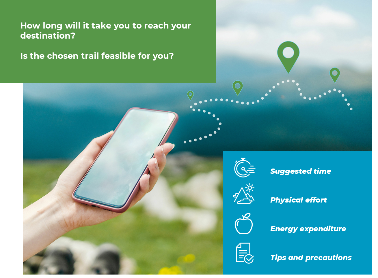
Predict customized hiking/cycling time, trail feasibility and expected physical effort, according to the users’ characteristics.
-
Offer personalized tips, precautionary health measures and a live tracking function for the planned outdoor activity.
-
Provide access to points of interest and refreshment facilities, by highlighting detailed information about key destinations/attractions to enrich visitors' experiences and encourage further exploration of the local area.
-
Provide a dashboard for customers showing the characteristics and activities of tourists in a specific area.
Service/ system concept
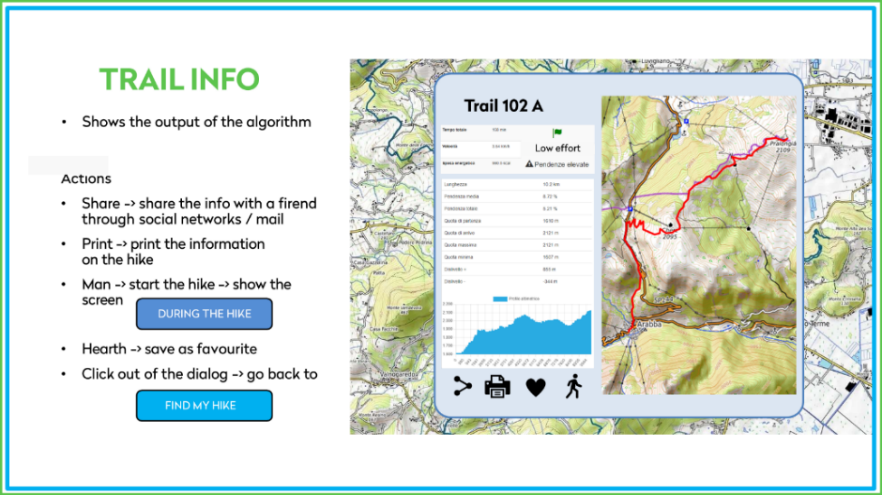
Based on a developed algorithm, the system is capable to predict the time needed for a certain user to perform and complete a certain physical outdoor activity, considering a risk-based safety margin.
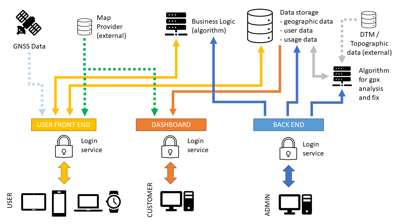
For this purpose, the algorithm needs to know the characteristics of the user and the trail; the former are communicated by the user through a front end, while the latter are extracted from a database of trails; both information are fed to our algorithm, which in response will create outputs for the user.
The system is also capable to track in real time the users’ progression, thereby updating its predictions: real time GNSS data are sent to our server that can then alert the user if he/she is going too fast or too slow or out of the track, update the elapsed and remaining time, and provide information on the path ahead and behind.
Information on users' activity is logged into a database and can be accessed as aggregated statistical data through a dashboard by our customers, providing valuable information to administrators and tourism managers.
Space Added Value
Space assets provide important data for the running of our service.
The use of GNSS navigation data will guarantee to track the user localization in real time during the outdoor activity, adding a new core functionality to the service that will be used not only before the activity for planning, but also during it, to receive relevant updated information about the ongoing activity (going too slow, too fast, elapsed and remaining time, ...). Moreover, knowing the users' position, the system is able to assist them in navigating through the environment, directing them to points of interest along the route or aiding them in not getting lost and, in case of emergency, send a geo-localized alert to a selected rescue contact.
The use of SatEO data in the form of DEM/DTM data will allow to create a precise database of trails/hikes, digitally surveying paths and removing errors from existing GPX traces through a validation process and an integrated algorithm. SatEO data, as weather forecast information associated with GNSS data, can provide insights regarding developing weather conditions. Thus, the planning phase can be improved, and the user will be alerted in case of adverse weather changes, an important safety aspect during outdoor activities.
Current Status
Major achievements of the feasibility study included:
-
Interviews with three major companies operating in the tourism sector of North-East Italy, to whom the project has been presented, discussing potential future business interests and cooperations. Additionally, three surveys have been conducted, targeting users, customers, and patients with chronic diseases, getting more information to specifically define their needs and requirements.
-
A technical feasibility study of the software, which was verified. Also, the algorithm was tested through different validation studies, showing good performance in predicting hiking times. A possible initial mock-up for a prototype was generated.
-
The development of a B2B business model proposal that highlights our unique features.
Moving forward, our next steps entail:
-
Identifying funding and investment opportunities.
-
Advancing with the development of an advanced prototype.
-
Conducting field tests of the tool in specified areas with real user cases.
-
Initiating a first marketing campaign.