
Objectives of the service
From planning to monitoring: the exploitation of satellite technologies in urban and rural microgrid life cycle
MOWGLI is a satellite-based solution that provides a set of services for optimal microgrid planning, designing, and operations and maintenance (O&M) applications in urban and rural areas of developing countries, with particular focus on India use case.
The system aims to answer the following general needs:
- Energy availability: avoid under or over sizing, leading to un-correct grid management
- Energy reliability: grid must be stable, to avoid black-outs
- Energy quality: service quality, to avoid customer dissatisfaction
- Energy awareness: aware use of energy by end-users
MOWGLI provides four main services that fulfil the needs described above:
- Strategic planning (site assessment)
- Microgrid optimal design (renewable energy sources basket, sizing)
- O&M (load balancing, remote control, anomaly detection predictive maintenance)
- Energy awareness and payments services (pay-as-you-go, smart-booking, priority-booking, community leasing, tele-medicine, tele-education, O&M training)

Users and their needs
The four MOWGLI i-EM proposed services involve benefit for the whole rural microgrid community:
- Decision makers (policy makers, funding entities, local entities and regulators): the satellite-based services involve better microgrid planning (optimal site selection) and conveys better decision reducing economical risks and improving country rural areas development. Remote microgrid control, fault detection, prediction and notification based on satellite communications reduce the economic risks. Remote performance monitoring based on satellite communication helps the assessment of the socio-economic impact of the microgrid projects. Energy awareness service based on satellite communication facilitate socio-economic growth of the local communities.
- Microgrid designers and developers: the space assets will involve a sustainable microgrid project: the EO satellite-based service should involve better microgrid planning (optimal site selection), design (optimal sizing) and implementation (required technology procurement) helping microgrid designer and developers to achieve long-term sustainability and return of investment.
- Microgrid owner operators (MGOs): EO-satellite based Energy Management System by i-EM will support optimal microgrid management. SatCom links will enable in field data acquisition and operator interface by an automated remote control, fault notification, predictive maintenance, performance monitoring, supporting operation and maintenance activities.
- End-users: the end-users will benefit of high quality and reliable energy availability at reasonable costs and they will be assisted by customer care services including energy secure billing digital services. They will also benefit from a socio-economic perspective fully exploiting the satcom link for of new commercial activities, safety improvement and tele-education.
MOWGLI value proposition
» Enhanced microgrid integrated services for strategic site selection, optimal design, and management of O&M activities
» Effective exploitation of EO satellites and SatCom images (provided by ESA)
» Best performance and end-users services by smart digital application
MOWGLI services market/customer segments
» Microgrid (with/without anchor load: renewable based electricity generation up to 10 kW and supplying electricity through a Public Distribution Network.
» Minigrid: renewable based electricity generation up to 1 MW and supplying electricity through a Public Distribution Network.
» Solar Home System: PV rooftop systems up to hundreds watt.
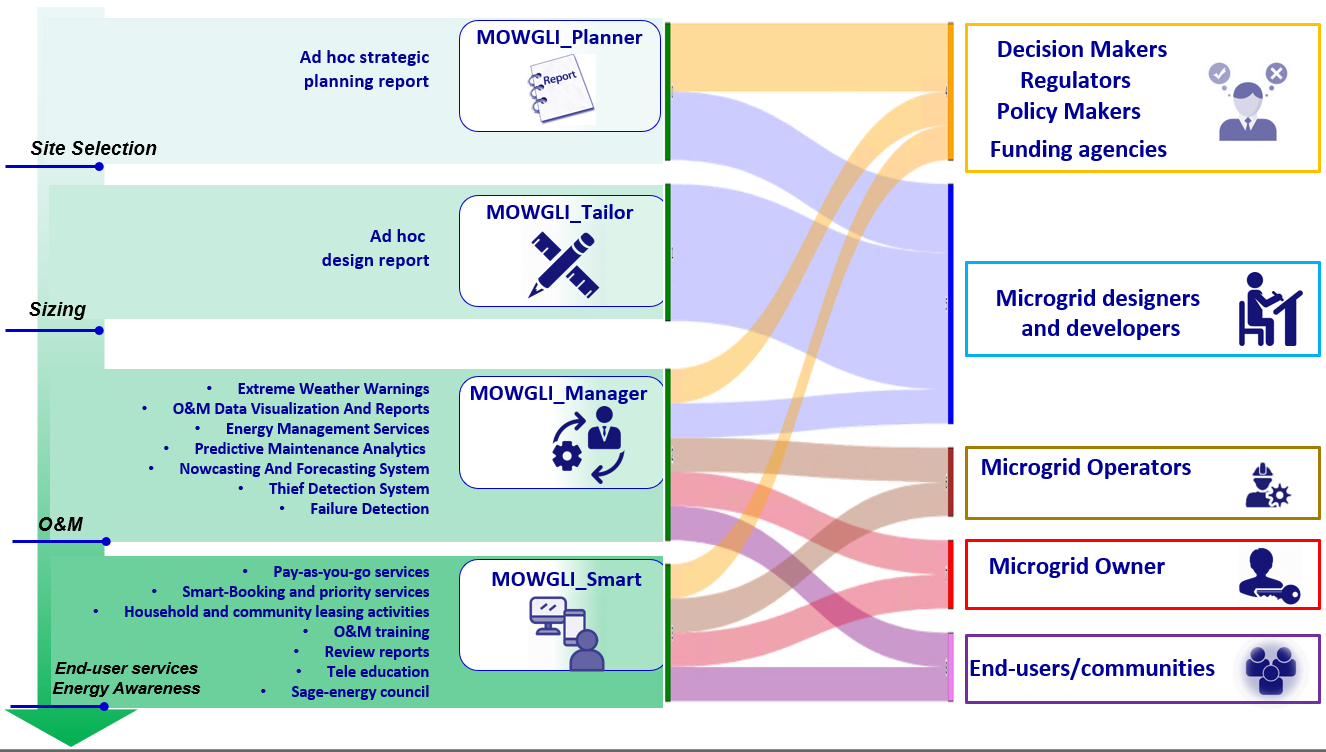
MOWGLI services and their relationship with users
The country of the targeted users for MOWGLI is India
Service/ system concept
The MOWGLI services and their main features are described below.
Urban area identification and classification using satellite imagery
The MOWGLI_Planner service is aimed to identify the sites with potential need for microgrid, by define the load needs, exploiting Earth Observation satellite images and taking into account the support of the specific rural area development.
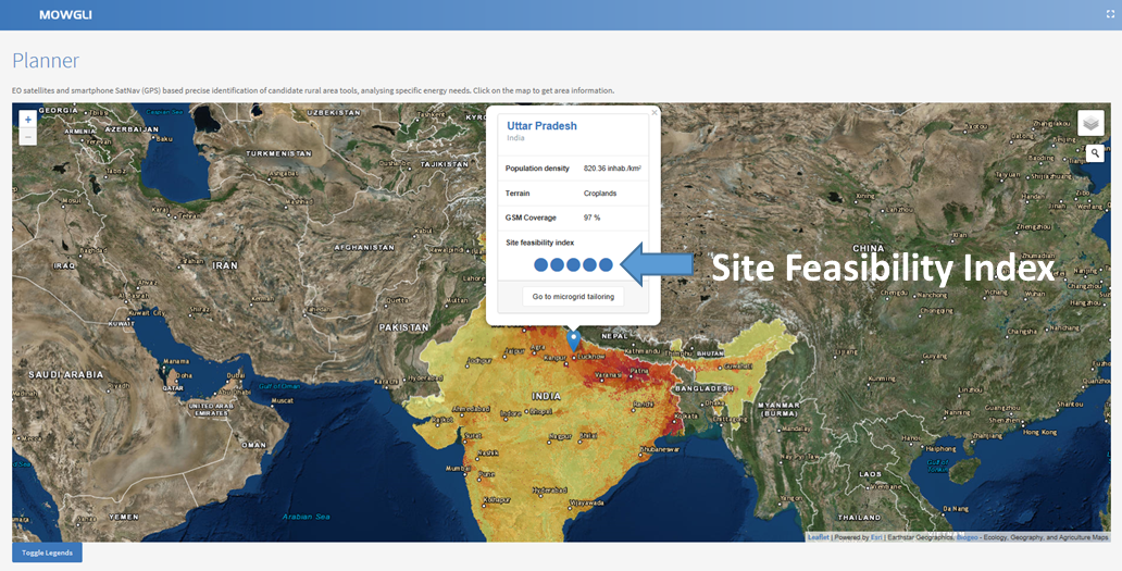
Main features
» Satellite imagery (EO) classification to identify:
» rural urban areas
» agricultural activities
» forest coverage
» Load assessment considering:
» anchor tenants and/or anchor loads
» agriculture and food facilities, health centers etc.
» required energy quantity and quality
» expectation of changes over time
Output
» Strategic planning withthe site identification
» Site Feasibility Index
Microgrid optimal design
The MOWGLI_Tailorserviceis aimed to identify the best microgrid design, taking into account the local energy sources availability (exploiting EO images) and the sustainability, scalability, and stability of the microgrid to realize.

Main features
» Renewable energy assessment: solar, hydro, and biomass (e.g., forest) resources
» Microgrid sizing and design with best components choice
» Simulation of microgrid behavior identifying the best configuration
Output
» Microgrid tailored-design report
» Microgrid Feasibility Index
» Technical design
List of services enabled: Tele-education, Tele-medicine, Smart payment, Priority booking
Microgrid Operation & Maintenance (O&M) services
The MOWGLI_Manager service is aimed to manage and monitor the microgrid, in terms of load balancing, black-out prevention and control, microgrid components fault detection and prediction, and sustainable maintenance strategy.
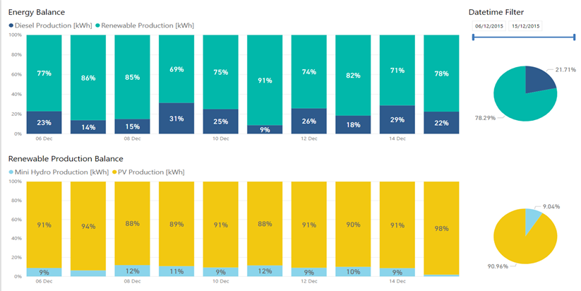
Main features
» Real-time monitoring
» Predictive maintenance
» Energy Management real-time System (EMS)
» Energy Management forecasting
» Load forecasting
» Extreme weather forecasting
» Energy thief detection
Output
» Information for O&M activities
Energy services and awareness for end-users
The MOWGLI_Smart is a set of mobile phone services for the end-users, for the customer care energy services and secure billing services, with the additional aim of improving the community energy awareness.
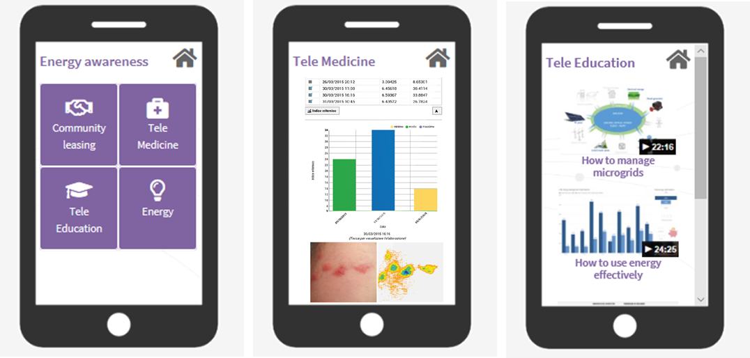
Main features
» Payment services:
» Pay-as-you-go
» Smart-booking
» Priority-booking
» Energy awareness services:
» Community leasing
» Tele-Medicine
» Tele-Education
» O&M training
Output
» Mobile and Smartphone application
In the following figure a High-Level system architecture of MOWGLI services, with the evidence of the i-EM components, the satellite assets (EO, SatCom and NavCom), the inputs required, and the services provided for each microgrid phase.
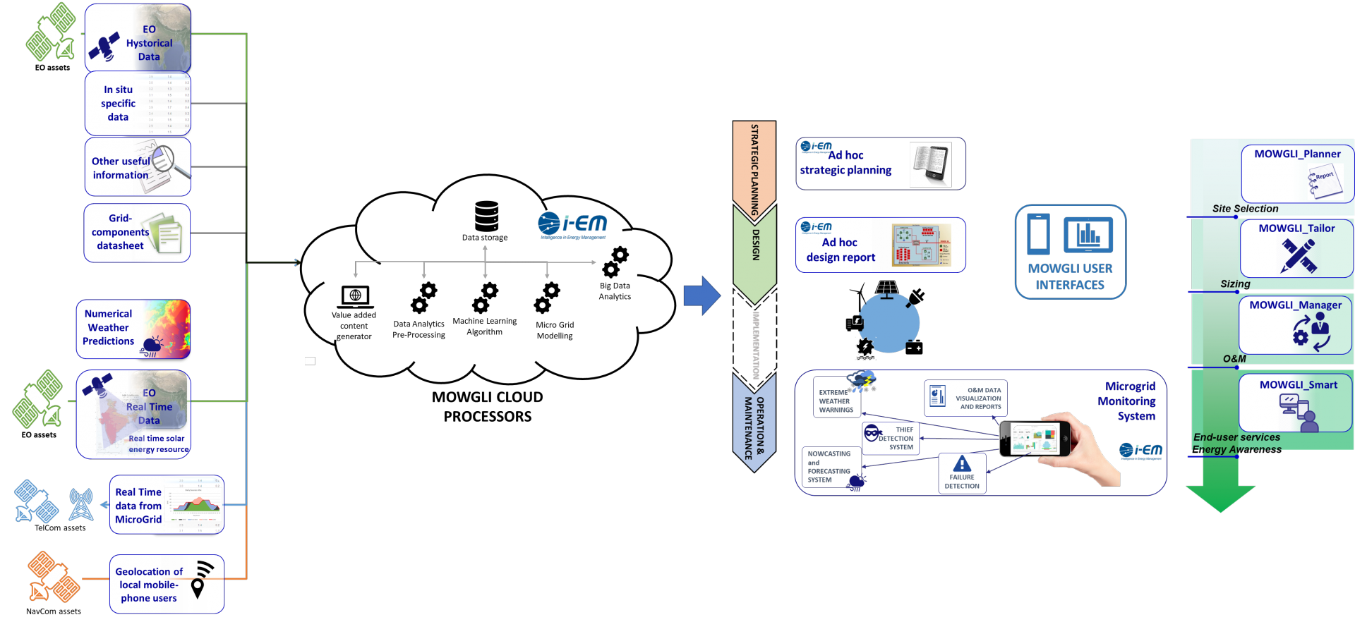
MOWGLI System Architecture: Space Assets involved, i-EM principal components and services in each microgrid phase.
Space Added Value
Space assets envisaged for the integration in the targeted services
» Earth observation satellites
Largely used in all the services as a remote and reliable source of data: energy assessments, real-time for monitoring and forecasting inputs.
» Telecommunications satellites
Used as complementing solutions where local connectivity is not reliable, or not available at all.
» Navigation satellites
Used to pinpoint the geolocation of local mobile-phone users, to understand their specific behaviour and needs, thus extracting information to better match the community needs.

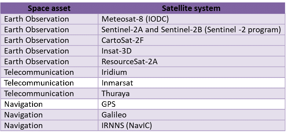
Table of satellites assets exploited by MOWGLI
Current Status
The technical and economic viability of satellite-based services to efficiently support the microgrid project phases have been assessed.
During the last months of activities, i-EM engaged three potential stakeholder which are interested in the demonstration phase and the exploitation of the services for potential commercial purposes.
i-EM participated the 9th – 11th 2019 at the 6th International Conference & Exhibition on Energy Storage, EV & Micro Grid, ESI EXPO Trade Fair, as silver sponsor (http://www.esiexpo.in/); i-EM joined IESA association in April 2019 and an ongoing collaboration with IESA has been established.


