Objectives of the service
Crop diversity is important for dietary diversification for enhanced human nutrition. One major obstacle for analysing crop diversity is the lack of information on crop location and type, especially within regions with subsistence agriculture. At present, there is no database and no efficient procedure that allows users to acquire cropping patterns. The proposed solution aims to identify crop types at micro field level using high resolution satellite data, allowing for the first ever derivation of crop patterns at household level, quantification of cash and food crops and crop growth trends. Within the scope of MYFoodS, the project consortium investigated the viability of Sentinel-2 earth observation (EO) data to assess crop types, estimate their micro yields, and ultimately assess food security at the household level. The nutrition framework of numerous randomly selected households of the Nouna Health District, Boucle du Mouhoun, Burkina Faso was investigated. The database was set up of household agricultural and nutrition surveys, anthropometric measurements of under-nutrition in children, as well as household crop yields. The collected in-situ data in the form of crop field boundaries were linked to a time series of high-resolution EO data.
Users and their needs
The MYFoodS consortium contacted potential users and stakeholders active in the sector of combating global poverty, malnourishment and climate change mitigation, to identify their requirements for the information service. The potential users are threefold: (1) governmental organisations, (2) financial and development institutions, and (3) non-governmental organisations. Depending on the stakeholder’s requirements, the crop yield monitoring service is developed as a graphical web-portal or as a mobile alert system, which mainly aims at directly supporting the authorities and organisations in their intervention planning.
Within MYFoodS, the service is developed for pilot users in West Africa. However, the service may be adapted to the requirements of users in other developing countries of Asia or South America.
Service/ system concept
In order to support the service uptake, a partnership between RSS GmbH (EO component), HIPH (public health expertise and local engagement) and CRSN (local stakeholder as centre of excellence) was established, allowing the set up of a value chain and the dissemination of the service.
HIPH acquired quantitative data from the population and qualitative insights from potential users in order to predefine the service concept. RSS obtains high-resolution Sentinel-2 data and processes the data in the in-house developed server-based processing chain. Time series are generated and multi-temporal statistical metrics, suitable to identifying crop types and estimating the yield, are calculated. The gained crop yield information is represented in maps or an information service which allows users to detect critical situations (e.g. yield loss).
Space Added Value
Free Earth Observation data from the Copernicus Programme is used to derive relevant parameters for an assessment of vegetation growth in micro fields over the growing period, with the aim to an early identification of crop losses and marginal yields affecting food security. Continuously acquired Sentinel-2 data is used to map cultivated areas, crop types as well as for yield estimation in micro fields in Burkina Faso.
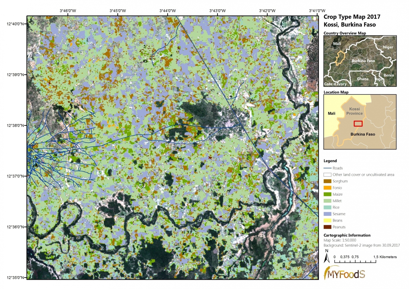
Result of the crop type classification
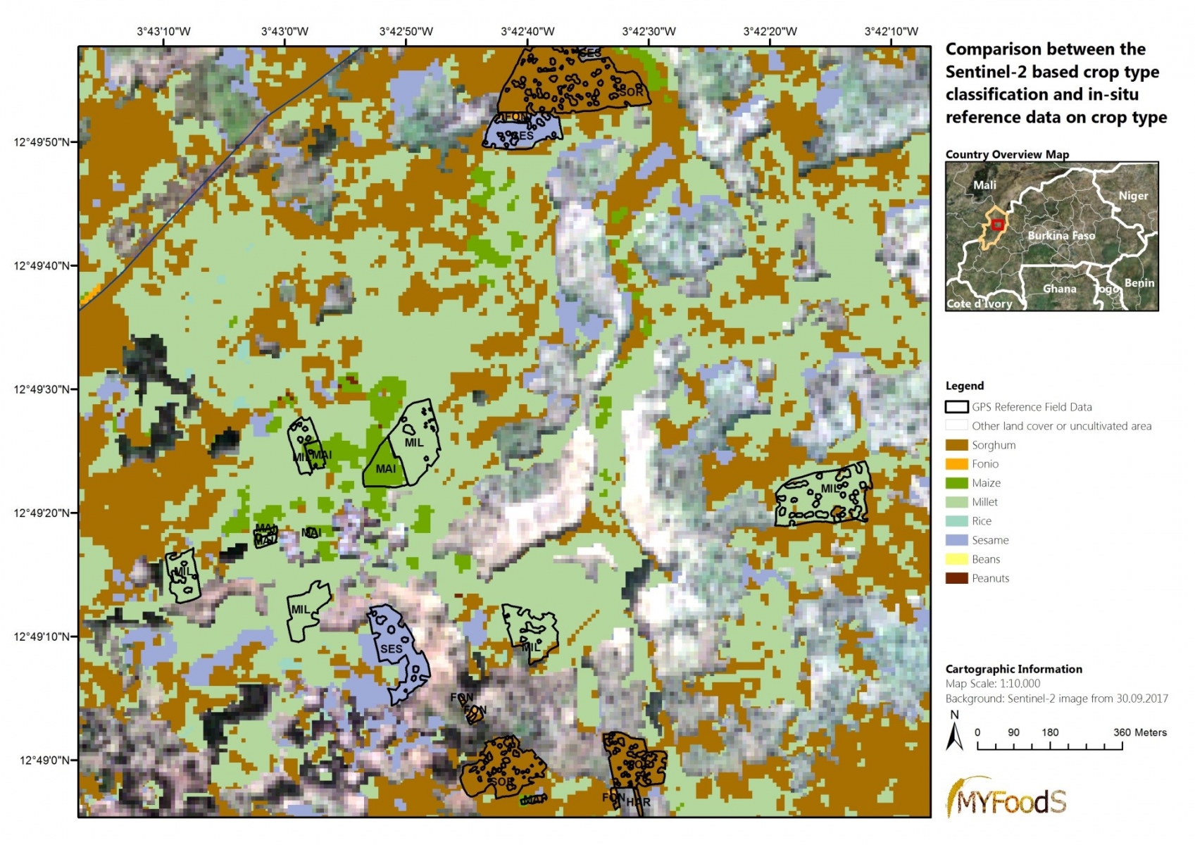
Direct comparison between the crop type classification and the in-situ collected reference fields.
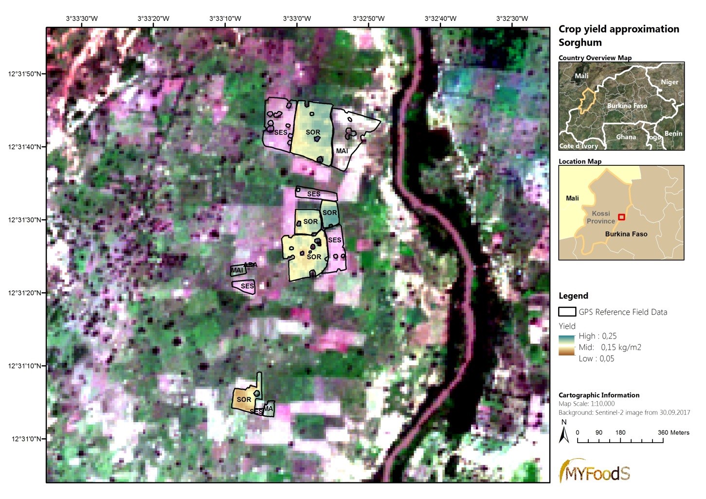
Example of a Sorghum yield approximation.
Current Status
The feasibility study has been successfully completed. The crop type classification was already demonstrated to users. Due to logistical issues, the reference data regarding in-situ measured yield weights lacks sufficient quantity for robust statistical analyses. As a result, the MYFoodS consortium continues to investigate the viability of high-resolution data for assessing micro yields and will realize a second field campaign in the growing season of 2018.