Objectives of the service
The main objective of NARWHALS project is to investigate the feasibility of a solution for a more robust positioning, enabling safer routes for Arctic Shipping, whose environment is characterized by:
- Severe environmental conditions,
- Fragmentary coverage of power supply and connectivity for GNSS satellites
In the Arctic area systems of based augmentation like EGNOS, WAAS and SBAS are not accurate for GEO satellite low angle of visibility and ionospheric disturbance.
NARWHALS solution will aim at enhancing the positioning accuracy integrating low power systems able to handle, forecast and interpret ionospheric data useful to mitigate the effect of the ionosphere on high accuracy positioning systems.
The idea behind NARWHALS is to provide information useful for the mitigation of ionospheric effects to GNSS service providers operating in Arctic region. This information, consisting in different parameters about the level of ionospheric disruption on the signal coming from each GNSS satellite, will be included in the correction messages sent to the final users.
NARWHALS is aligned with the medium-term objective of SET/INGV to extend the GNSS precise positioning to marine shipping and matches the willingness of the SET/INGV-ISMB partnership to offer a customized solution for the GNSS networks set-up in hostile environments.
Users and their needs
NARWHALS Team collected responses to a customized questionnaire of 6 service providers and 18 End Users of GNSS services.
The most demanding needs emerged from questionnaires are:
- Improving navigation accuracy in shallow water and within ports
- Improving precise localisation to successfully manage search and rescue operations
- Improving accuracy in GNSS positioning for mining activities
The users could be divided by field
- Search and Rescue
- Maritime
- Land
- Research Institutes
- Government
- Transportation
NARWHALS service will be integrated in the services provided by service providers, in order to ensure backward compatibility with the existing services and devices already in use.
Service/ system concept
NARWHALS architecture leverages on a network of reference stations collecting GNSS data and transmitting them to a central unit that runs a patented algorithm to enhance positioning performance in Arctic and Sub-Arctic regions.
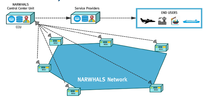
The network is composed of Narwhals System Units (NSU) that transmit data to Control Center Unit (CCU). Each NSU acquires GNSS data that are pre-processed and sent to CCU. The latter manages GNSS data by using an innovative algorithm to mitigate GNSS positioning error in the Arctic. These corrections are sent to service providers that distribute services to End users such as shipping and airline companies.
NSUs are based on small clusters of low power devices to efficiently collect and pre-process data while optimizing the power consumption with a precise management of devices’ duty cycles.
The CCU, on the other hand, can be generally intended as a process running the software that implements the algorithms for:
- the forecasting of TEC and scintillation parameters;
- the evaluation of the mitigation parameters by using forecasted ionospheric information.
Space Added Value
The feasibility study aims to overcome problems in the Arctic due to the GEO satellite low angle of visibility.
To this end these assets will be used:
- the ESA Swarm constellation:
- the AMPERE experiment by the IRIDIUM constellation,
- the Space Weather Service provided by SSA.
Current Status
The Kick-start activity has the goal to investigate a possible solution for a more robust positioning aiming at enabling safer routes for Arctic Shipping.
To this end, three main activities have been done:
- Identification of stakeholders and their needs
- Technical Specification of the proposed service
- Economic Viability
The activity was successfully completed in December 2018.