Objectives of the service
The NbS Monitoring service delivers a streamlined Earth observation-based approach to provide accurate, timely, and comprehensive assessments of medium to large-scale NbS peatland projects, increasing the confidence and transparency of project outcomes, and saving costs and time for customers.
The initial focus is on peatland restoration projects within Voluntary Carbon Markets (VCMs). In recent years, the VCM has been under scrutiny to develop projects that can be reliably and accurately monitored, reported and verified (MRV) in order to build trust in a rapidly developing market. Earth observation data provides a science based and repeatable approach to identify suitable sites for future peatland projects and provides ongoing support with transparent methodologies for baselining and monitoring these long term carbon emission reduction projects.
Users and their needs
The NbS Monitoring service is working with key stakeholders in the VCMs who are focussed on delivering high quality, repeatable and science based MRV.
Users for this service can be broken down into three groups:
-
Project suppliers – such as landowners/managers, regional authorities, and scheme developers who require independent quantification and monitoring of their schemes to help market their service and help adapt land management practices to improve outcomes.
-
Third party standards, registries, and verification organisations – companies offering certification of a scheme e.g., Verra or Gold Standard, who are interested in improving the reliability and credibility of the methodologies used within their voluntary carbon standards (VCS) program.
-
Consumers, companies, and governments – those looking to offset their carbon who require an independent verification that their investment is delivering the stated claims both in terms of carbon offset but also local social benefit.
The project is currently UK based, but in the long-term could be expanded globally.
Service/ system concept
NbS Monitoring delivers a set of services which use remote sensing methods to provide both regional site identification for prospective VCM projects and site-specific monitoring products for individual projects. EO data, in conjunction with any in-situ data available, enables tangible and repeatable measurements over specific study areas to establish changes that have occurred over time. In collaboration with project developers the NbS team can support initial baseline assessment and annual reporting in line with carbon code requirements.
The service architecture diagram outlines the approach with an initial site assessment, using a range of regional scale EO and climate change datasets tailored to site suitability appropriate for a project. These are supported by commercial EO data as required. Processing techniques are designed to identify and monitor key indicators relevant for each environment. For example, for a peatland code project peat extent, depth and condition over time are used to quantify the emission reductions from restoration activities.
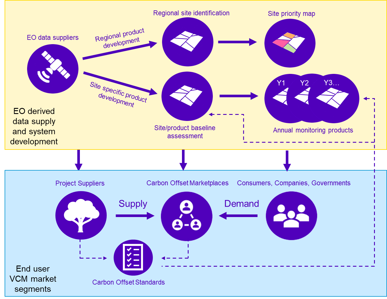
Final products aim to be compatible with requirements of the relevant carbon code and include digital reports, summary maps and statistics of site carbon sequestration or emission reduction over time, with online access as required.
Space Added Value
Obtaining accurate and reliable MRV outputs is key to the success of the NbS Monitoring service. To achieve this, an integrated approach using multiple EO datasets, including free to access Sentinel-1 and 2 and commercial VHR, hyperspectral and radar data alongside innovative processing techniques is required. Validation against in-situ field data is important to build trust in the system and increase the uptake of the service.
Current Status
The NbS Monitoring project commenced in November 2023 and held the PM1 meeting in early February and the BCR in June 2024. The Final Review was held in August 2024.
Prime Contractor(s)