Objectives of the service
NetVR has the objective to provide accurate asset information in the real environment from different utilities on one platform without a heavy administrative and technical burden.
The targeted clients are the network utilities that can get a better view on their own assets, but also get one unique platform to get insight on other utilities’ network assets required for their work, without the need to share more of their data than strictly needed. The first group of users is therefore the network utility personnel.
A second group of users are the network utility’s subcontractors. These are a huge group of users of network asset data day in and day out. When their information is not accurate enough or is not available in time (or not asked for in time), this will lead to inefficient work and potential calamities. For example, accidentally breaking a pressurised water pipe or gas pipe can have large consequences.
NetVR will facilitate more efficient work done with less administration and less calamities.
Also in case of emergency, the need to have accurate data readily available is important to e.g. emergency services and utility managers, so that crucial decisions can be taken without losing time.
Users and their needs
Users of utility asset information need an easy to use tool on standard devices that is usable in the field and works with a simple application that takes the current administrative and technical burden out of their hands. The application must be accurate and give to the point visualisation of the underground assets.
When a user wants to get access to the utility asset data in a certain area through NetVR, the user will have to apply digitally for access grant. When this access is granted to his account for that area, the user will be able to directly see the utility assets. The application will automatically retrieve the data from the different utility servers.
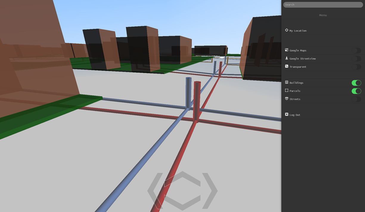
NetVR will achieve the required accurate and to the point visualisation through a Virtual Reality viewer of the underground assets in global 3D digital twin that is triggered by the position of the used device. The visualisation will incorporate all necessary asset characteristics, but still remain as simple as possible. The accuracy of the positioning of the assets is the key issue to become the market challenger and breaking open the market for this kind of applications; this will be achieved by the proposed calibration tool.
Service/ system concept
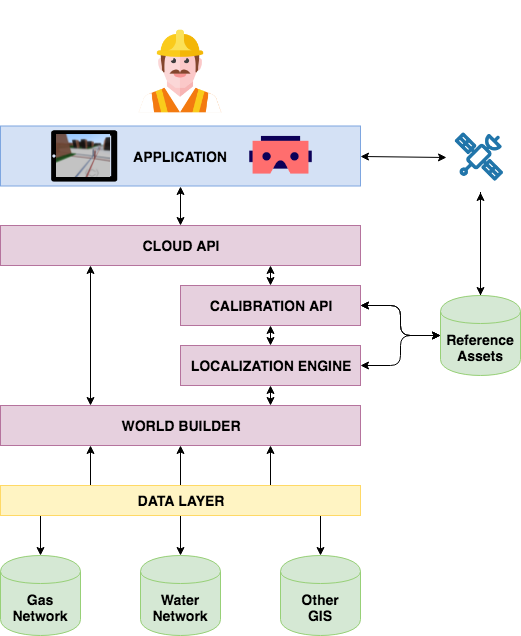
The following usage scenario highlights the roles and interactions of and between the different components (represented in the figure below):
- Once on the terrain, the user starts the Application
- Using the device’s GPS, the application acquires a basic geolocation that it transfers to a Calibration API in the cloud
- The Calibration API uses the device's location to acquire the location of existing Reference Assets nearby
- From the Reference Assets, the Localization Engine calculates the very precise location of the user’s device
- Based on the accurate location, the World Builder collects Data Layers available in that area that the user has permission to use. Then, it compiles them into a 3D virtual world that it returns to the Application
- The Application renders and displays the virtual world to the user, who can then interact with it in real-time using the basic sensors of his device (e.g.: accelerometer, touch screen)
- When the user moves, the accurate GPS localization is updated
Space Added Value
Currently, the centre point of every manhole cover is determined, using GPS with centimetre accuracy (RTK or RTX). Collection of these data is a relatively high cost and forms a valuable source of data for better positioning of these and other assets. These data are very accurate reference points that are available all over the city.
NetVR will unlock this valuable reference data and create an additional added value for this data. This is again done by using space technology, i.e. GPS, but in this case using the cheaper standard GPS solutions that are built in into standard devices as tablets and smartphones. These standard GPS solutions have a more limited spatial accuracy that limits the exact localisation of underground assets, but by combining the already accurately measured reference data points with a local calibration tool based upon the standard GPS positioning, NetVR aims at a significant increase in accuracy of the positioning of underground assets in the outside environment, without requiring expensive GPS technology and the related know-how. This revalorises the expensive data collection and opens it to many users and might be even valorisable into other domains of accurate terrain positioning.
Current Status
The success criteria have been identified during the feasibility study by questioning several contacts, who represent more than 3000 potential individual users in different businesses (contactors, private data owner/industry and multi-utility).
A technology has been chosen to develop the application.
The overall performance of the correction algorithm is an average reduction of the distance between the measurements and the reference with a factor 4. Building shielding still plays an important role for further reduction of the positioning error. Further investigation on long-term stability of the result is needed. Other solutions for positioning must be compatible as well.
A steering committee is set up, guiding the further development. The positioning protocol and XR visualisation are the first focus in further development. In parallel, agreements will be made on the platform, data access and usage. A commercial application will be available in 2022, which will be commercialised in Flanders and internationally.