
Objectives of the service
The current tsunami warning systems are based on the estimation of numerical simulation as well as on the measurements of tidal gauges and buoys located along the coast but not all countries are covered by these instruments, and even when they exist they are usually too close to the coast to provide warnings with much time in advance.
The numerical simulations are not enough accurate in the confirmation of the tsunami wave and some false alerts were issued in the past. This fact provoked the incorporation of tidal gauges and buoys measurements to confirm the generation of the tsunami and provide useful information but these tools require expensive maintenance. In addition, some emergency services like the ones of Indonesia have stated the loss of quite a few of those instruments, leading to a faulty tsunami warning system.
OneWave will merge the measurement of the signature of the tsunami visible in the sea level observed from space with the information provided by existing Tsunami Warning System to verify.
The access to the satellite data could be implemented using near real-time capabilities available allow to prevent the authorities in charge of alerting the population when the tsunami waves are still travelling through the ocean.
Users and their needs
A clear user segmentation have been identified. In the international domain the TWS are mostly organized by the UNESCO Intergovernmental Oceanographic Organisation:
Caribe Tsunami Warning Center (Caribe EWS) in Barbados Pacific Tsunami Warning System
(PTWS) in USA operated by NOAA
Northwest Pacific Tsunami Advisory Center
(NWPTAC) hosted by Japan
North-Eastern Atlantic and Mediterranean and connected seas TWS (NEAMTWS) operated by the following Tsunami Service Providers
France (CENALT), Greece (NOA), Italy (INGV), Portugal (IPMA), Turkey (KOERI)
Taking into account the occurrence of tsunami events, Deep Blue Globe has concentrated his efforts in the IOTWMS (Indian Ocean which includes countries like China, India, Indonesia, Malaysia, Singapore,…) but keeping also the focus oo the NEAMTWS (Europe).
Service/ system concept
OneWave will complement the existing Tsunami Early Warning Systems focused in the following points:
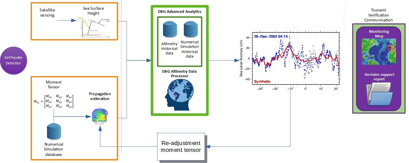
- The tsunami verification is done from altimetry satellite missions measurements, an existing infrastructure which is maintain by space agencies providing the altimetry data for free. It will take advantage of the data measured by the buoys and tide gauges sensor networks and published by international institutions like IOC UNESCO or European Commission Joint Reaserch Centre.
- An advanced model which learn from the historical tsunami numerical model data and historical altimetry data to performed an enhanced tsunami detection and verification.
- OneWave uses altimetry data to re-compute the Focal Mechanism, the numerical element extracted from the earthquake physical parameters and used by tsunami numerical model to generate a Tsunami Time Travel (TTT) estimation map and a Tsunami Sea Wave Height (TSWH) estimation map. A re-compute of this element allows the Tsunami Early Warning System to improve the estimation of the time arrival and magnitude of the wave reaching the coast helping the alert process to the population.
OneWave high level system architecture
Space Added Value
The tsunami verification is done from altimetry satellite missions measurements, an existing infrastructure which is maintain by space agencies providing the altimetry data for free. In a first stage, the system will use Sentinel 3 Copernicus family satellites.
OneWave is taking advantage of the Copernicus Collaborative Ground Segment concept which enables access to satellite scientific data in local areas through what is called Local Dumps to specific ground stations, different from the Core Stations used by the Copernicus Mission to get access to the complete science data.
Current Status
Even prior to start of the Deep Blue Globe organised in June 2019 a videoconference with Copernicus Emergency Management Service group at Joint Research Centre -JRC- from the European Commission to introduce OneWave and get a better knowledge of their needs. These needs will convert into requirements and discussed again with JRC later at the end of the year 2019.
In preparation of the kick start activity a workshop with LAPAN and AIRBUS was held to establish the agenda of the joint collaboration. LAPAN propose to do a workshop with in Jakarta to work on the preparation for a demonstration phase, currently planned by
Deep Blue Globe, as ESA BIC incubatee got ESOC Mission Analysis support to validate DBG strategy for the Time to Reach Tsunami Analysis. Validation of OneWave vision was done with the EUMETSAT Altimetry Scientist Team.
As part of the Copernicus Accelerator Closing bootcamp, at the InterGEO conference in Stuttgart, was put on the focus of the Copernicus Start-up Community.
OneWave has been pitched in two important international events. Invited by UN-SPIDER, Deep Blue Globe has been presented in the International Conference "Space-based Solutions for Disaster Management in Africa”. The participatation in the Sixteenth Session of the ICG/NEAMTWS, in Cannes invited by IOC/UNESCO allow us to get a very intensive
Deep Blue Globe has been invited by EUMETSAT to participate on the Copernicus Collaborative Exchange at the premises of its partner Plymouth Marine Laboratory to engage a technical exchange on the Altimetry data processing of the Copernicus Sentinel 3 satellite.
A proof of concept of the different modules has been implemented in python and a end-to-end processing is already available.