
Objectives of the service
OPT4SOL uses AI to analyze spatial data that describes the surroundings to create the spatial profile of a given location. OPT4SOL will consider the selected spatial profiles to identify ‘similar’ locations that could be ideal for solar installations. The system uses close to 70 different spatial data types from Hungarian and European sources that can influence the positioning of solar installations. These include: population data, industrial areas, land use, areas with below average economic land evaluation values categorized, agricultural production types, ownership structure of land, drought index, land value, high and medium voltage electricity network, substations, existing solar installations, Natura 2000 areas, protected areas, applicable maps from the national territorial plan, excluded zones from solar development, Sentinel-1 and Sentinel-2 satellite images.
Users and their needs
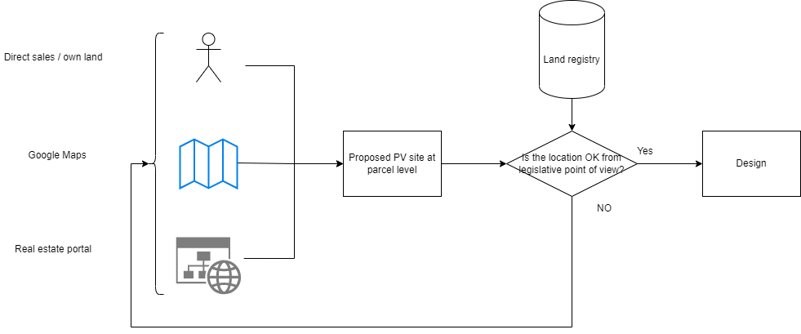
Utility-scale PV solar panel project developers and operators have a huge need for spatial data to identify project opportunity areas and to support the planning phase of a project. Currently these users rely on diverse sources for accessing information used to determine suitability of locations with few, if any platforms that integrate all types of sources of spatial data for site selection. Our tool will help provide them with this and improve the cost effectiveness, speed, and quality of analysis underlying site selection.
OPT4SOL was developed to be versatile and user-friendly. It provides a tool to analyze all its data using traditional GIS methods for site selection. The system, however, is also capable of incorporating additional spatial data, or locations thought to be good from developers to create custom AI models that can rate territories within selected areas – this can encompass the whole country – on how similar they are to the good locations provided by the developer.
Service/ system concept
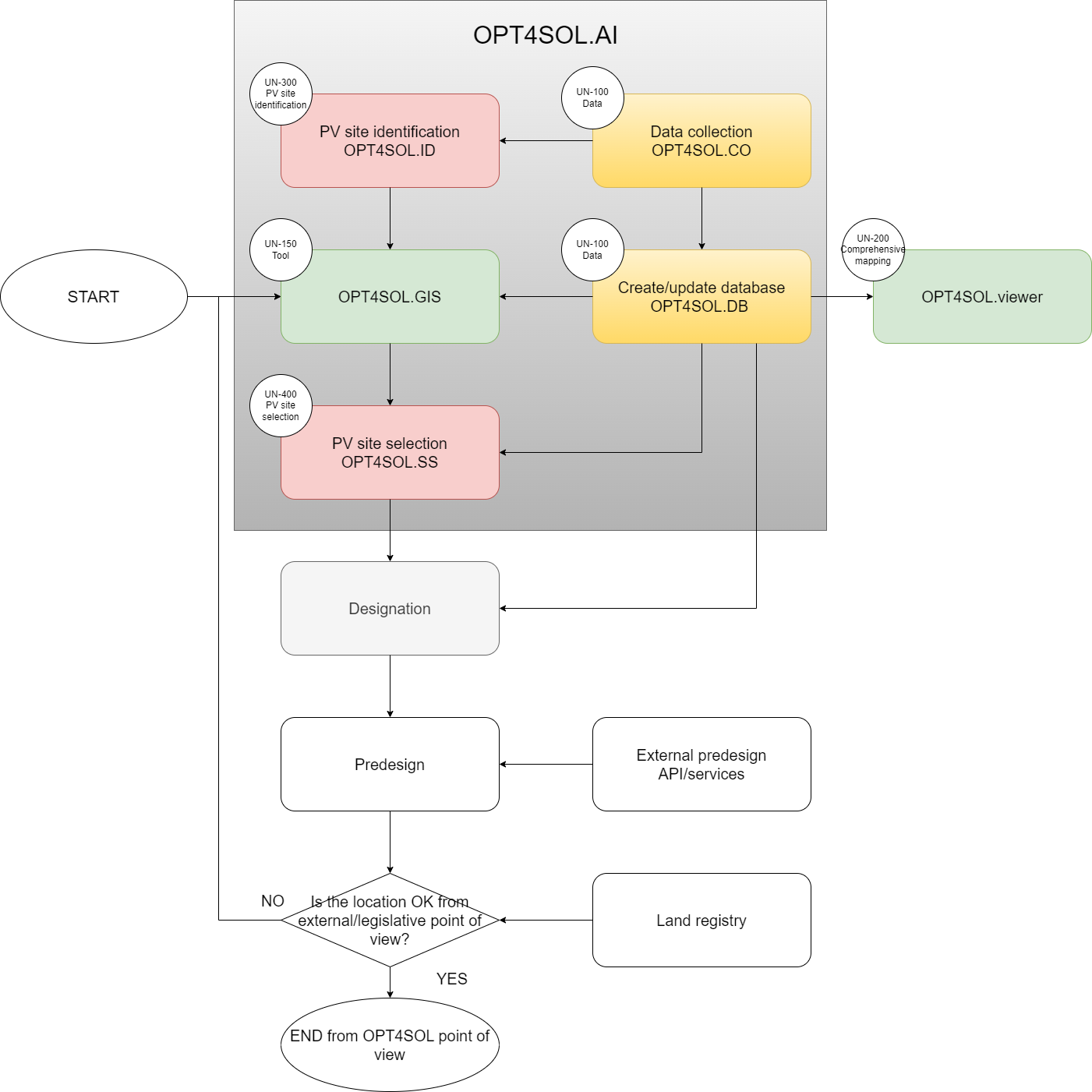
The OPT4SOL.AI has the following main components from the user’s perspective:
-
OTP4SOL.CO – this module is responsible to collect all information (satellite images and other spatial data) required by the components of the OTP4SOL system
-
OPT4SOL.DB – this module is to provide a central database for all spatial data for PV site selection,
-
OPT4SOL.ID – this module is to identify the newly built PV sites in order to provide a comprehensive PV site database,
-
OPT4SOL.GIS – this module is to support the user to define the target areas and the “competitors” to be evaluated by the selection module,
-
OPT4SOL.SS – this module is to score the proposed location based on the existing PV sites selected by the user,
-
OPT4SOL.viewer – this module is to provide all basic relevant information for PV sites development.
Space Added Value
The space assets used in this project will be Earth Observation data (Satellite images and derived data) obtained from the Copernicus Sentinel-1 and Sentinel-2 mission.
This data is crucial for the product and provide input not available from any other source that is central to the product. Satellite images will be used to identify existing PV installations and this task could not be accomplished without the use of satellite images.
The Earth observation data will also enhance and enrich the other data sources of location-based data. The quantified parameters of the satellite images and the derived products serve as input parameters of the AI/ML training and model along with other infrastructural, land use, land cover other datasets describing the neighbourhood of the existing and planned PV sites.
When not used to identify the PV sites, the earth observation data will still be crucially important for the analysis. The added value of using this data is that it will significantly improve the accuracy of our descriptions of a given area. The satellite images are the best source of information for evaluating agricultural land and this data will give a quantifiable view / data source about an area, which both strengthen and complement other variables of the investigated area.
The use of satellite data to describe the characteristics of an area is well known, especially in regions where official data is scarce. The frequency with which satellite images are updated support the faster recognition of land-use changes compared with the widely used register-based data sources.
Current Status
Opt4Sol.AI stands at the intersection of technological innovation and market demand. Its advanced AI and GIS capabilities meet a significant market need in the rapidly expanding solar energy sector. With a scalable and adaptable service model, Opt4Sol.AI is strategically positioned to capitalize on the growing demand for renewable energy in Europe, starting with Hungary and extending to other EU countries. The combination of technical feasibility and strong business potential makes Opt4Sol.AI a noteworthy player in the future of solar energy development.
The KickStart activities have confirmed the technical feasibility of the proposed solution and highlighted the added value of the space assets, one of the distinguishing technical novelties implemented in the project.
The service's AI capabilities are a cornerstone in evaluating and ranking potential PV sites. The AI models employed are designed to process complex datasets, including raw and derived satellite imagery, terrain features, land use, and solar potential data. The central technical questions of whether the use of machine learning models can be used for both PV site identification and selection has been demonstrated to work.
Opt4Sol.AI leverages a combination of satellite imagery, GIS, and AI to optimize site selection for utility-scale PV projects. The technical feasibility of this service is underscored by its innovative approach to integrating diverse data types. This includes population data, land use, network parameters, and Sentinel satellite images. The AI-driven system effectively analyzes spatial data to create profiles for potential solar installation sites, identifying optimal locations with high accuracy. With nearly 70 different spatial data types, the system's comprehensive database supports a thorough analysis, enhancing the decision-making process for site selection. This technical prowess positions Opt4Sol.AI as a significant advancement in solar energy development, catering to the growing need for efficient and data-driven solutions in the renewable energy sector.
Prime Contractor(s)
Subcontractor(s)