
Objectives of the service
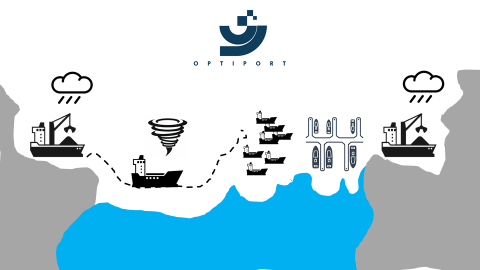
A significant contributor to the global GHG emission is the “hurry-and-wait” behaviour in tramp shipping. OPTIPORT is a Just-in-Time Arrival service that calculates optimal port arrival times for vessels currently underway by leveraging data from Sat-AIS and geospatial analytics.
This problem is tackled by combining the capabilities of StormGeo (weather forecasting, fleet performance and vessel routing) and Oceanbolt (port congestion, commodity trade flows and AIS data processing).
StormGeo and Oceanbolt provide highly specialized solutions, which are not overlapping. Seamless combination of the data streams will close data gaps and reflect a high-resolution real time picture of the situation. This is beneficial for shipping companies to mitigate uncertainties and risks, and thus effectively base operational and strategic decisions on reliable and actionable data.
The ambition of OPTIPORT is to allow for port call optimization, thereby reducing fuel consumption and GHG emissions, while minimizing economic inefficiencies. Smart vessel routing algorithms and solutions developed by StormGeo are already responsible for reducing global CO2 emissions by more than 3 million tonnes for the vessels that are incorporating its services. Vessels spend 20% of their voyage time at anchorage and thanks to the introduction of OPTIPORT an additional 3 million tonnes of CO2 emissions can be cut.
Users and their needs
Users of the proposed service are shipping companies and operators.
Shipping companies need to reduce the fuel consumption of their fleet and are obliged by regulations or initiatives to track GHG emissions on the voyage-level.
Operators want to limit the time spent idle at anchorage because it is costly and not economic. The time spent at anchorage might be better spent at sea by sailing at lower speeds as it directly impacts the fuel performance of the vessel. A high confidence of the vessels’ ETAs (Estimated Arrival Times) is required in order to ensure a high degree of planning reliability and allocation.
Furthermore, a solution is required that is contractually enforceable and where risks and cost savings are clearly outlined.
Companies are in need of a solution that integrates with existing data infrastructures and minimizes friction of using. Last but not least, a platform to connect and share operational information with relevant stakeholders is required.
Service/ system concept
The key objective of OPTIPORT is to integrate port congestion information into the routing strategy of a vessel’s voyage. By doing this in a timely manner, it is possible to reduce the speed of a vessel, thereby adjusting the consumed fuel, while minimizing the idle time at anchorage. A vessel's fuel consumption relies heavily on the vessel speed, so reducing the speed when a delay happens in port can easily save money and emissions. This is often referred to as Just-in-Time arrivals in the shipping community.
The port congestion data is a quantified number of vessels, average waiting time, commodity carried and volume (deadweight) congested. Based on this data, the vessel’s speed can be reduced or increased. It is necessary to introduce benchmarks for speed and consumption to be able to calculate the impact of the speed adjustments on the fuel consumption and CO2 emission.
For a successful implementation of OPTIPORT and the unlocking of just-in-time arrival strategies at scale, the solutions must be made available through delivery mechanisms already present on the ships, as there is a need for immediate correspondence between planning and execution. This is a demanding task involving multiple stakeholders, including the crew on-board (captain, navigator and engine room) as well as operators ashore. Also, it is important to note that coordination with commercial stakeholders is needed to achieve flexibility in adjusting routes, speeds and timetables.
OPTIPORT combines StormGeo’s vast experience within weather forecasting, fleet performance and vessel routing, with Oceanbolt’s experience within port congestion, commodity trade flows and AIS data processing for the dry bulk segment. These individual company competencies are complementary for solving the problem of just-in-time arrivals for shipping, as it involves a real-time feedback loop from knowing the operational status of both ports (e.g. congestion, berth availability) and vessels (e.g. position, routing, cargo). Our application is novel in the way that we combine satellite-derived insights to be able to predict optimal arrival times rather than relying on traditional port-to-ship communication channels, allowing for a greater time window to adjust vessel behaviour.
Space Added Value
Our service combines three space assets, SatNav, SatCom and Sat-AIS. SatNav provides vessel routing, and SatCom provides communication between personnel at shore and at sea. In the context of OPTIPORT, this provides for a link to adjust vessel behaviour based on the insights generated from the optimization model. Sat-AIS is the only comprehensive real-time source for vessel positions and is used to quantify operational metrics such as congestion, and to give a holistic view of the fleet in terms of destinations and commodities carried. It is the intersection of these technologies and the derived data that will allow us to provide port stakeholders with a Just-in-Time Arrival service.
Current Status
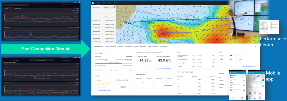
The consortium is currently working on the systems and service architecture with a first step being the integration of an OPTIPORT module in StormGeo’s platform. We remain open for interested users, who would like to participate in a demonstration project.