Objectives of the service
Construction and demolition waste makes up 41 % of the total waste generation in Denmark and just over one third of the total waste generation in the EU. However, despite relatively high recovery rates of used materials in most EU countries, most of the recovery of construction waste is largely based on low-grade backfilling operations.
Higher and better-quality recycling of existing building materials is needed to reduce the carbon footprint of the construction industry, and ultimately reduce costs – yet largely incomplete and outdated information about existing building assets impedes efforts to make longer term planning and integrate such resources in existing/future projects.
Earth Observation (EO) technology holds significant potential to address this data gap as a timely and synoptic resource to provide up to date information about urban objects as well as resource availability, location, typology, and condition. Thus, EO could provide new avenues for improving resource efficiency and circularity within the building and construction sector – and tap into a market believed to be worth between 10-12 million € per year, in Denmark alone.
Against this background, DHI GRAS and ORCA carried out the ESA funded Kick-start project entitled ‘Orbital Assets’ to assess the technical feasibility and commercial viability of EO technology to 1) map building objects and elements and assess the typology of potentially reusable building material/deposits in urban areas to underpin circular economy objectives and 2) monitor the condition of buildings and their surroundings to inform smarter maintenance frameworks.
The conducted activities aimed to:
-
Undertake a stakeholder analysis to assess user requirements, hence gain knowledge on the different user perspectives and needs when conducting activities in urban environments;
-
define the system requirements of the EO solutions and outline a technically feasible high-level architecture of the service, based on the identified user needs and the consortiums conceptual idea;
-
assess the economic and non-economic viability of the most promising solutions, by developing a sound business case and identifying risks of different nature that could undermine the commercial success of the service.
Users and their needs
The proposed solutions of Orbital Assets have global reach in their conceptual design, but the feasibility study had a geographic focus on stakeholders in Denmark. The user requirements analysis started with a long line of interviews with key stakeholders from the following segments:
-
The construction sector (including renovation companies, property developers and demolition contractors)
-
Construction product manufacturers (including resellers and distributors)
-
Architects (in the fields of buildings, renovations, urban planning and landscape)
-
Engineering companies
-
Technology and data providers for the abovementioned segments
-
Local a nd national authoritites
-
Environmental agencies
User requirements was also uncovered through informal meetings with other relevant stakeholders in the margins of other business activities as well as during a project workshop conducted in March 2022, which aimed to reach a broader group of stakeholders and present the project findings.
Outcomes on the different perspectives on data needs and application potential of EO data in the building segment, can be summarised as follows:
-
There is a general need for improved and updated, data and information about built up areas and building elements. Most all stakeholders operating in the building segment apply a broad range of data and information products to underpin their activities, from baseline information about the overall composition of the urban landscape (both grey and green) to detailed information at building level. However most existing datasets are incomplete or outdated and does not provide the spatiotemporal requirements needed. EO data is considered a cost-efficient resource to provide standardised and up to date urban inventorying.
-
Data requirements at building level are typically very high, requiring highly granular details on building condition and resource asset quality. Such data requirements are satisfied through significant on-site surveying, associated with high costs and complexity. EO data is generally considered unlikely to meet the data requirements at building level, however several stakeholders indicated an interest in applying coarser level EO data as a means to target in situ surveying campaigns.
-
Limited data exists providing information on quantities of building resources in the existing building mass. There is wide range of users with a high interest, even in coarser and less accurate data, if any such data can be sourced through EO. This is particularly true for local authorities, who could make use of this data to facilitate innovation within urban design and circularity as well as demolition companies who could apply it to inform assessments of project scope.
Service/ system concept
In line with the overall service requirements, the following high level service architecture, presented in Figure 1 below, was proposed as an overarching framework to deliver a flexible multiservice infrastructure.
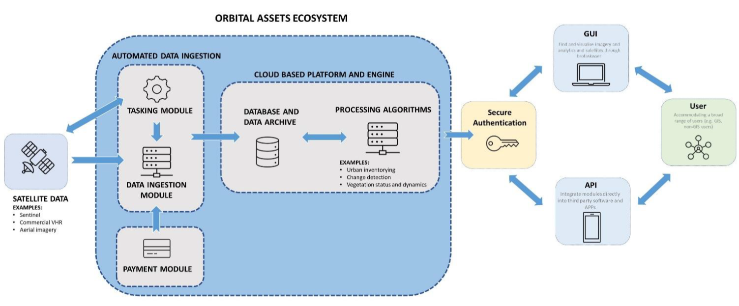
The system architecture consists of:
-
An automated data ingestion module which automatically loads the latest publicly availableEO data, i.e., Sentinel, Landsat and orthoimagery (if available), depending on end user needsand requirements in terms of temporality and granularity, for their specific area of interest(AOI). The module also includes a tasking module through which commercial satellites can betasked to acquire imagery during a specified time interval.
-
A payment module for automated payment of commercial Very High Resolution (VHR) dataservices (tasking and data archives)
-
The main cloud platform and processing engine which stores all available satellite imagery forthe AOI in a database. The platform also includes a selection of different processingalgorithms which can be executed on demand, or run on a schedule, to perform various dataanalytics on the available satellite imagery.
-
A secure authentication module which provides access to the user specific environmentwhich is set up to include all the user defined AOI’s.
-
Flexible data and imagery access through a tailor-made data portal, API, WMS service orsimilar, in line with key user needs and their existing infrastructure.
Space Added Value
Orbital Assets will rely on commercially available VHR data as well as free and open higher resolution data provided by the Danish Agency for Data Supply and Efficiency (SDFE) such as spring orthophotos, oblique aerial photos, lidar data and vector reference datasets. A thorough evaluation of how each of the data sources individually, and combined, contribute to meeting the overall objectives was conducted as part of the activity, in order to inform the most cost-effective and efficient design.
It is the intention to assess the extent of which exploitation of satellite data in combination with higher resolution data sources is able to provide timely, cost-efficient and comprehensive monitoring regimes of built-up environments, at parcel level. Such updated and complete spatiotemporal insight is not currently available, or too costly, through traditional means.
Current Status
The project was completed in April 2022.
Key conclusions indicated that the two most promising solutions identified during the activity were:
-
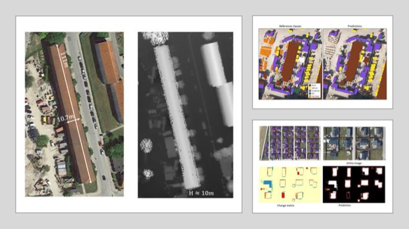
A service to conduct automated mapping and change detection of building polygons,primarily targeting existing building registries managed by state and local authorities, as wellas architects in need of basic building data and information in unfamiliar settings.
-
A service to estimate building resource volumes through combined geometric analysis andorthoimagery, primarily targeting demolition companies.
The technical feasibility assessment of the two services generally confirmed the technical feasibility to derive data and information in line with core user needs and requirements. However, in order to meet the quality needs of the end users, both services require source data beyond the capabilities of existing freely available satellite data and are thus depending on publicly available orthoimagery. Such data is available nationally in Denmark; however, this is not the case in all countries and as such may be a limiting factor in terms of scalability across the EU, assuming that the data quality needs are equally high in other countries. Lastly, while automation potential to underpin national scalability potential was confirmed for service 1, through application of deep learning technology, service 2 require significant manual efforts by trained specialists. Further technical assessments will need to further conclude automation potential of service 2.
The analysis further indicated that there may be a business case for both services.
Prime Contractor(s)