Objectives of the service
Climate change and higher pressures to water resources are some of the main causes of increased water use, which has resulted in competition for water, over exploited (ground) water resources, degraded land and reduced ecosystem quality. To meet the demands of a changing world in the 21st century, and to save lives, water and money, the water management processes need to be improved significantly.
An obstacle for improved water management is the lack of data on water availability. Water resources management can only be effective with good quality and appropriate data available. Therefore the consortium, led by HydroLogic BV from Amersfoort took the challenge to investigate and define services for improved monitoring, forecasting and control of water availability under the project acronym OWASIS-NL.
During the study, two services were identified that help water managers to get the right information in the right time to the right person to support the right water management decisions:
- Soil Water Storage Capacity Monitoring and Forecasting Service: provides water managers with historic, current and forecasted information on the soil water storage capacity. Based on this information the risk of drought and flooding can be reduced and decisions can be taken on the distribution of water.
Water Auditing Service: This service provides the end user with an overview that shows the water use from irrigation and compares this to the water allocation. Based on this information the user can monitor water use in large areas and can take measures to prevent excessive water use by farmers.
SERVICE/SYSTEM CONCEPT
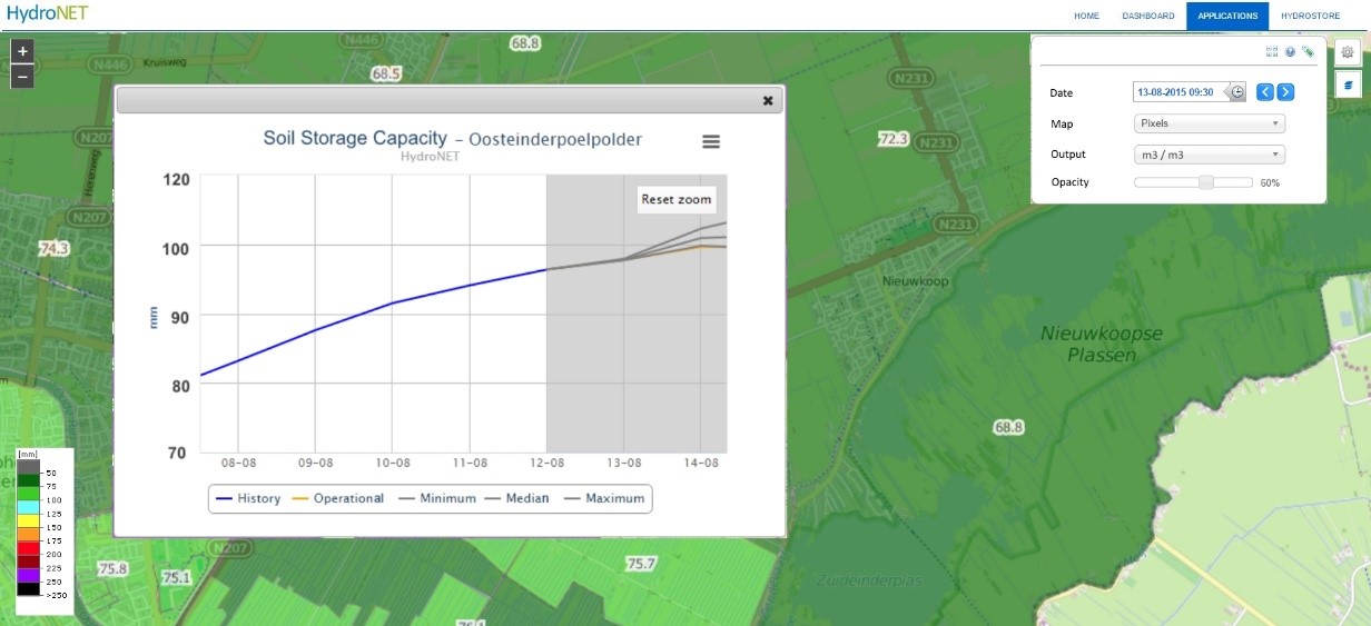
Soil Water Storage Capacity Monitoring and Forecasting Service:
The soil water storage capacity monitoring service provides insight in the current and forecasted water storage capacity of the soil. The values of the soil water storage capacity per pixel or entity are presented in interactive maps. The user can request a graph with the time-series by simply clicking on the map. After clicking on the map a graph will appear that displays the historic, current and expected (2 day forecast) soil storage capacity for this area.
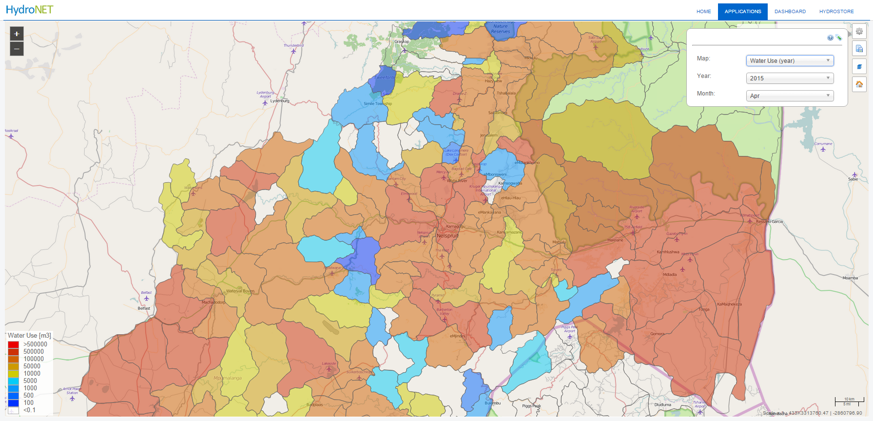
Water Auditing Service
The water auditing service provides information on the water use by irrigation and compares this to the amount of water that is allocated to a specific area or field. The water auditing service provides the user maps and graphs displaying the water use per pixel, administrative area or field and compares this to the allocated amount of water. The colour in the area indicates the ratio of cumulative water use compared to the cumulative allocation.
The services will be developed using the price winning HydroNET platform. To do so, the required hydrological data sources will be connected to the HydroNET server. On the HydroNET server, algorithms and models are used to calculate the soil water storage capacity and the water use. The information is presented to the end users in interactive maps and graphs trough a regular web-browser, tablet or mobile phone.
Users and their needs
The OWASIS-NL feasibility study aimed to identify profitable, space-data based water availability applications for Dutch and international users in water authorities, agro-food sector and multinational industries. A broad range of users was selected since exactly the same water availability data is used for multiple end-users. The participating and contributing users in the OWASIS-NL demonstration project were:
- Water Management Authorities in the Netherlands and South Africa: responsible for the water distribution within a river basin or catchment area. To do so, water managers gather information about the current state of the water system and the weather forecast. Currently, the available information on water availability is in most cases incomplete, inaccurate, dated and crucial information about the soil storage capacity is missing. To improve this situation, water managers need a reliable estimation of the soil storage capacity on a day to day basis.
- Agro Food Industries in Ukraine and Russia: The primary task of the agro-food sector is to produce food in an efficient and sustainable way. Agriculture accounts for 70% of withdrawals of freshwater resources and is a major draw on water from aquifers. To improve the efficient use of water and to increase the food production, a reliable estimation of the water use is needed. Currently, this information is not available because irrigated fields are spread over large areas of land and can therefore not be monitored from the ground.

- Multinational industries: Industries need (fresh) water as input in their production processes, as cooling water, process water or for energy production using hydro dams. Furthermore, many industrial production plants are vulnerable to floods; therefore information is needed to prevent damage from flooding.

Netherlands, South Africa, Ukraine, Russia.
Space Added Value
Two types of space assets were subject for integration: Earth observation and satellite navigation.
Large areas of the world lack in-situ monitoring needed to measure essential water availability data. This makes the collection of essential data for water availability applications a challenging task.
Remote sensing technologies have proved useful in acquiring data on poorly measured areas. Furthermore remote sensing technologies provide data on larger spatial scales compared to most in-situ measurements. Another benefit of using remote sensing is the low cost of acquiring the data (compared to in-situ collection) and the immediate availability of the assets.
In this study we specifically investigated various techniques like optical measurements, radar altimetry and laser altimetry to gather data on land use, rainfall, evapotranspiration, soil moisture or water levels of inland water bodies.
Satellite navigation technology is used to obtain the location of the user providing local data via his mobile phone or tablet, and to geo-tag in-situ measurements for validation and calibration.
The OWASIS-NL feasibility study showed that the use of space assets for water availability monitoring is especially suitable for:
- Monitoring precipitation in area’s that are not covered by radar or gauging networks.
- Forecasting of precipitation using numerical weather prediction models.
- Monitoring and forecasting of evapotranspiration using satellite based algorithms and models.
Monitoring of soil moisture.
Current Status
The study was finalized in January 2016. The OWASIS-NL consortium has submitted a roadmap with recommendations to proceed to an IAP Demonstration project that focuses on the demonstration of the ‘Soil Water Storage Capacity Monitoring and Forecasting Service’ and the ‘Water Auditing Service’.
Prime Contractor(s)
Subcontractor(s)