Objectives of the service
In England alone, it is estimated that 26 million people are living with at least one LTC. Whilst many LTC patients received drug therapies, it is known that physical activity also has a significant benefit to the majority of LTC patients. Despite this knowledge, there is minimal uptake of exercise with the LTC cohort due to a number of factors including:-
-
Perceived inability to undertake exercise in line with the current healthcare guidelines
-
Negative effect of exercise outside due to environmental factors (increased exposure to polluted air, high pollen count)
-
Lack of motivation and inability to see the direct positive impact on patients’ health
-
Insufficient support to engage/promote physical activity
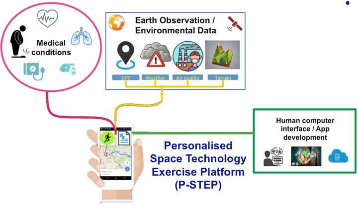
P-STEP is a smartphone App designed to overcome perceived barriers to physical activity for people with LTCs by bringing together clinical and environmental technologies and expert medical knowledge in order to:-
-
Provide personalised exercise advice and guidance using evidence based research
-
Provide suggested routes and activities derived through the use of ESA Earth Observation and Air quality data in order to maximise the benefits of physical activity for users
-
Provide engaging and motivational features to encourage user engagement
-
Easily adaptable platform for incorporating new medical evidence or wearable technologies
Users and their needs
The app is being designed by and for people with LTCs, initially the focus will be in three disease specific areas i.e. cardiovascular, respiratory and diabetes.
-
Users need evidence-based exercise specific advice tailored to their condition combined with air quality information to support outdoor exercise
-
Users need to be able to plan their exercise routes taking into account the air quality
-
Users need motivational tools to support and track their progress
-
Users need to be able to personalise the app
-
Users need the app to be simple to use
-
Users need a way to share their progress with friends, family and health professionals
-
Users need the app to link to wearables
Challenges faced in designing P-STEP are met by integrating user focus groups throughout the design and piloting phase to ensure that the app meets the user needs. Evidence-based clinical and environmental guidance is provided by linkage of expert medical knowledge and space-derived locational and environmental data.
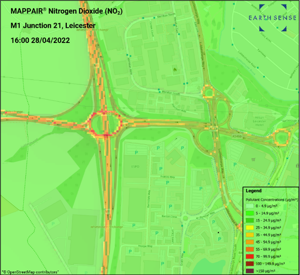
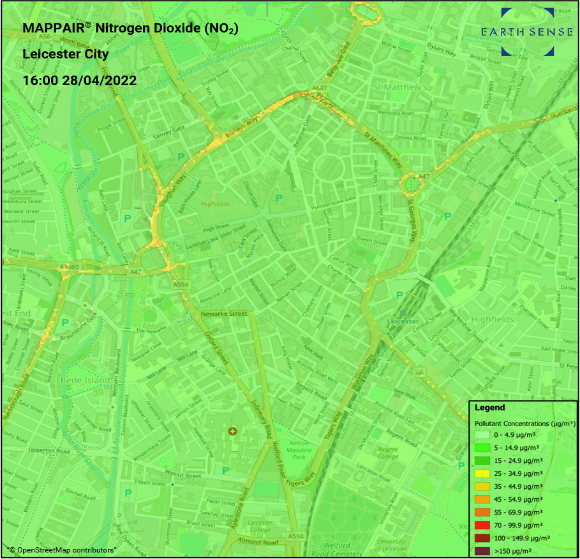
Users in the Leicester area will test the App and will have access to 10m resolution data, 100m data is available throughout the rest of the UK.
Service/ system concept
Users of the P-STEP app will have access to:-
-
Expert medical and exercise knowledge combined with space-derived locational and environmental data
-
Real-time exercise route mapping giving preference to ‘clean air’ and ‘green space’ routes
-
Progress tracking and feedback to support user motivation including enhanced user engagement through gamification and augmented reality
-
Ability to personalise the app e.g., to be able to choose the type of data they want to see and share
-
An easy to use/simple design
EarthSense will provide the P-STEP app with satellite obtained real-time data on pollution and the weather via an API (Application Programming Interface). The app will link this data to a user’s location/chosen route by accessing the Global Navigation Satellite System (GNSS) in order to provide pollution and weather data for that specific user’s location/chosen route.
The app will provide personalised disease-specific exercise based on clinical and environmental guidance in the form of an algorithm. The app will also provide tools to enable self-management and motivate users.
Space Added Value
The only way to provide users with real-time data on the environment is to use space enabled data products.
-
EarthSense will provide the space-enabled data products. For the prototype, EarthSense will assess and utilise where appropriate remotely sensed data including L2 NO2 data from Sentinel 5P, to enhance regional import estimates within the air quality modelling; CAMS data for a range of species, including NO2, O3, PM2.5 and PM10. Meteorological data (EUMETSAT via ECMWF) will contribute wind vector information to inform pollution dispersion. Rainfall and temperature will also be utilised.
-
Satellite Navigation Data – GNSS data will be used for motion tracking of users and will support routing.
Combining the real-time data with expert clinical and exercise advice will provide users with the most relevant guidance as to when the best time is to undertake outdoor exercise.
Current Status
Following the funding extension award (CCN1), the P-STEP app continues to be developed to include the conversion to iOS, linkage to wearables via the Terra API and assessments of commercially available air pollution data providers.
We have undertaken User/Stakeholder engagement meetings prior to Baseline Design Review to understand the types data to be accessed from wearables and how this data could be utilised with the P-STEP app.
The migration from jetpack compose to compose multi-platform; serving as a single codebase for both android and iOS is well underway, and early independent testing has highlighted only minor issues.
A review of commercially available AQ providers has been undertaken in order to broaden the use of the P-STEP app beyond its range of the UK.
Prime Contractor(s)

Subcontractor(s)