Objectives of the service
Land resource use problems and environmental sustainability issues pose a serious risk to the palm oil sector. The sector has been under increasing public scrutiny and pressure whereas the rapid expansion of planted area to meet the growing demand can have significant environmental and social impact. Much of the criticism has focused on the establishment of oil palm plantations at the expense of high conservation value areas and high carbon-stock lands (e.g. intact forests and peat land). In response to this, efforts are underway on the certification of environmental sustainability of palm oil production, reporting of carbon footprints, and efforts to increase productivity of existing plantations, among others.
Challenges remain in demonstrating compliance as well as credible carbon stock assessment. Moreover, the fragmented character of production areas, with a large number of smallholders distributed over large areas, often presents problems for ground audits as well as for a cost-effective assessment of productivity and fertilizer needs
The PalmOilVision service aims to strengthen corporate environmental sustainability and carbon footprint reporting, and to increase production efficiency in the palm oil sector. PalmOilVision supports growers, consumer product manufacturers and other stakeholders using integration of optical and radar satellite remote sensing technologies, UAS and satellite positioning.
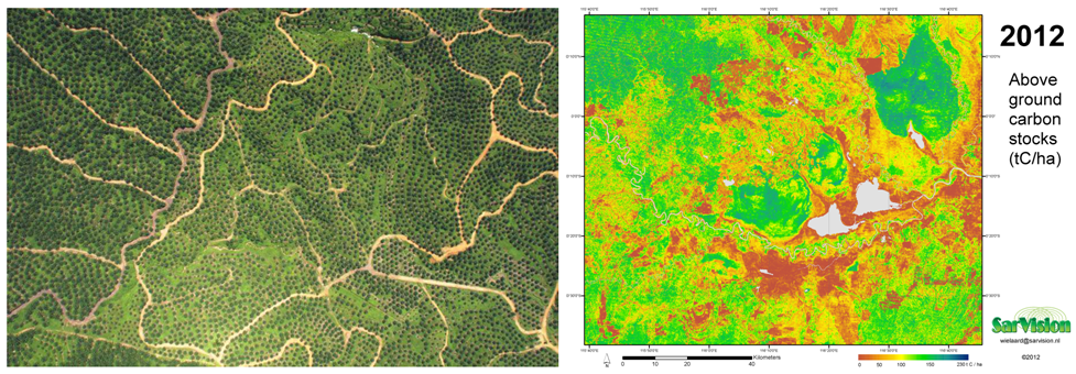
Left: RGB image of an oil palm plantation from RPAS (courtesy MosaicMill); Right: Above ground Carbon Stock map using Landsat satellite imagery and ground data (courtesy SarVision).
Users and their needs
The PalmOilVision service targets growers and millers, consumer product manufacturers and other stakeholders in the palm oil value chain.
Palm Oil growers and millers need accurate and timely geodata for monitoring their existing plantations, for planning new plantations, and for managing supplies.
Together with consumer goods manufacturers, they also need geodata to demonstrate environmental sustainability of their operations. During the recent years and in the course of the feasibility study, major actors in the palm oil supply chain have announced new palm oil sourcing policies with zero deforestation commitments.
Other stakeholders, such as environmental NGOs and organisations working on the traceability of commodities, are also potential customers of the PalmOilVision service.
The proof of concept has been carried out in leading producer countries Indonesia and Malaysia. The aim of PalmOilVision is eventually to target all producer countries throughout the tropics.
Service/ system concept
The system concept considered at the beginning of the feasibility study consisted in:
- Earth Observation: Satellite remote sensing technologies including high resolution radar (Sentinel-1, PALSAR-2) and high resolution optical (RapidEye, Landsat/Sentinel-2) data. Radar-optical synergy can deal effectively with semi-persistent cloud cover enabling consistent mapping of land cover, systematic monitoring of forest cover changes, and carbon stocks mapping;
- Satellite positioning: RPAS with autopilot navigation (e.g. RTK GNSS Galileo, or DGPS) is used for robust, standardized collection of sample recording of parameters related to carbon stocks (canopy height model) or plantation productivity (related to yield and fertilizer requirement, diseases). GPS is used for geo-referencing of ground-truth data used for calibration and validation of land cover and carbon stocks maps;
- Internet – interface: service available to a wide-ranging user base through an automated online delivery system (specifically growers, but also other stakeholders).
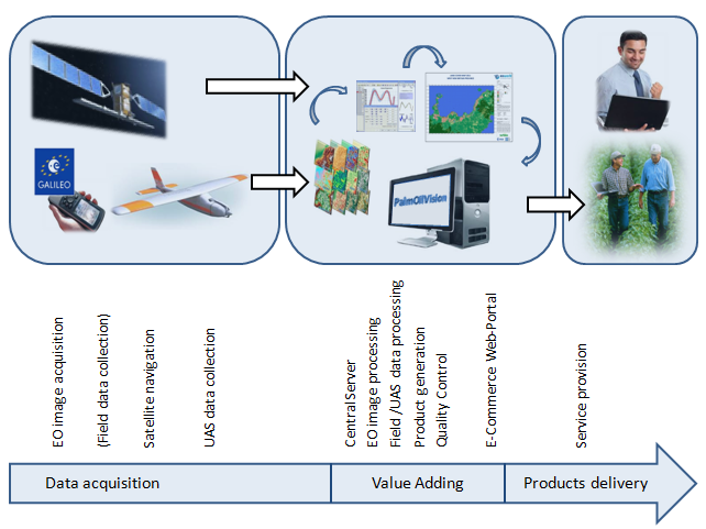
PalmOilVision provisional service architecture
Given the outcomes of the feasibility study and viability analysis, only the earth observation and internet interface components will be used in the future PalmOilVision service.
Space Added Value
Current ground-based verification of sustainability and reporting is time-consuming, often not timely, inefficient and expensive. The ‘PalmOilVision’ service is being designed to reduce the field work component required to gather information. Data acquired from satellite images and other space assets, analysed in conjunction with a minimal set of ground-based data significantly reduce the time and money required to perform field surveys.
The integration of optical and radar satellite technologies with RPAS and satellite navigation services results in scalable, reliable, timely and cost efficient services.
A fully deployed ‘PalmOilVision’ service is expected to add user value in the following ways:
- Increased efficiency: monitoring of environmentally sensitive areas on a large scale, checking success or failure of mitigation strategies;
- Cost savings: synoptic overview of very large, often poorly accessible areas, more targeted field surveys.
- Higher data quality: scientifically robust and objectively measurable, repeatable, historical information.
- Transparency: independent and objective information sources with timely access.
Current Status
The PalmOilVision feasibility study started in April 2014. After analysing the user needs, a state of the art review has been conducted and led to the definition of the service architecture and components.
A series of service products have been prepared for demonstration in order to test the technical and market viability of Palm Oil Vision services.
- Monitoring of vegetation cover changes with high resolution optical images (Landsat) and radar images (Sentinel-1);
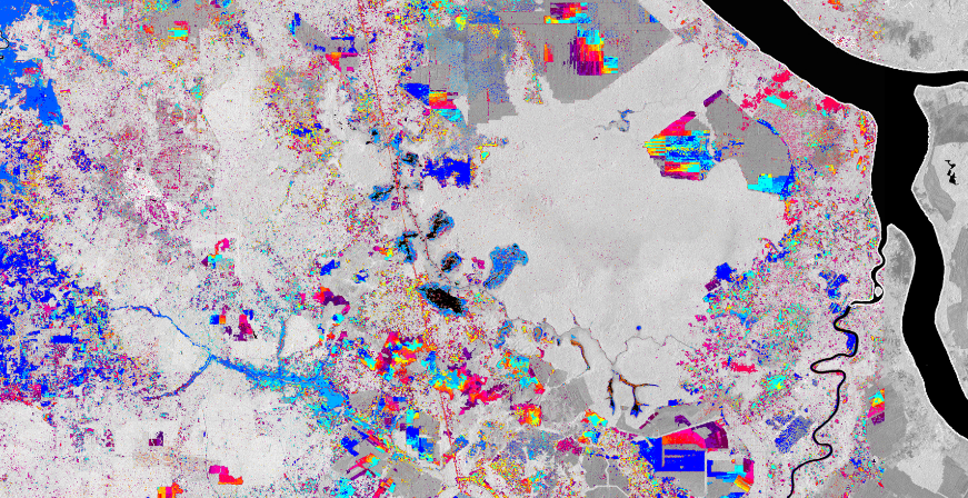
Sentinel-1 processing chain outputs for vegetation cover changes monitoring (SarVision
- Land cover mapping with with high resolution optical images (RapidEye) and radar images (Sentinel-1);
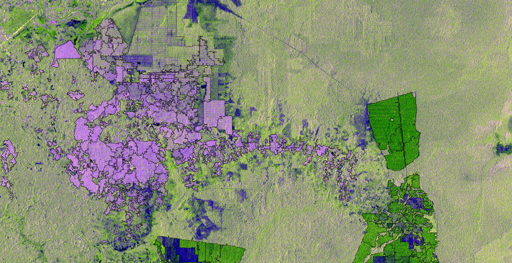
Sentinel-1 processing chain outputs for land cover mapping (SarVision) (logged peat forest in light green, acacia plantations in dark green, oil palm plantations in purple).
- RGB and NIR ortho-photos mosaics acquired with UAVs on oil palm plantations
- Canopy height model derived from RGB ortho-photos mosaics acquired with UAVs
- Hyperspectral ortho-photos mosaics acquired with UAVs on oil palm plantations
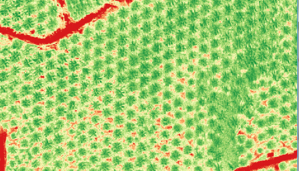
Red-Edge NDVI index map derived from UAV hyperspectral imagery (MaVinci, Rikola, MosaicMill)
After analysis of feedback from users on these service products and based on the outcomes of the technical feasibility and market viability analyses, it has been decided to focus Palm Oil Vision services on oil palm production sustainability.
The study has been concluded in January 2016. Since then, SarVision has engaged and partnered with major organisations providing such services. SarVision will focus in the future on the SAR component of the services. A future IAP demonstration project might become relevant depending on next steps in the development of the services.
Prime Contractor(s)
Subcontractor(s)