
Objectives of the service
Maritime traffic in the Arctic is expected to grow over the next years due to an elongation of the ice-free season along the northern sea routes caused by global warming. However, ice-free does not mean that there is no ice. Planning of marine activities in the polar regions will remain difficult due to constantly drifting sea ice. Unfortunately, every ice chart or satellite image of the ice situation is already outdated the moment it arrives on board a ship. Pathways through the ice, identified on a satellite image, might already be closed when a ship arrives in the region. While several sources for ice information exist on the market, presently, there is no high-resolution ice forecast product available. PRIIMA solves that problem by converting static satellite images into real-time information and even into animations showing the future drift of sea-ice over the next hours and days, while the resolution of the images is being conserved. PRIIMA automatically corrects the position of ice on a satellite image to its present location and is therefore a requirement to use satellite images in a tactical navigation system on board. PRIIMA can best be compared with radar based short-term rain forecasts in modern smartphone weather apps.
Users and their needs
The following segments of the maritime industry are active in the Polar region and in need for forecasted ice information: Service icebreakers, cargo shipping, maritime authorities, expedition cruise shipping, fishing vessels, the oil & gas industry and surveying and exploration ships.
Typical jobs to be done where PRIIMA can contribute are:
- Find the fastest way through the ice (icebreaking ships)
Pain: Satellite images do not match with the present position of the ice. Tactical navigation by means of satellite images is therefore difficult.
Gain with PRIIMA: Information on how a crack in the ice cover develops enhances planning security. Travelling along an open crack safes ship time.
- Keep production safe and running (exploration and oil&gas industry)
Pain: Uncertainty when to stop production due to close-by ice fields.
Gain: Forecasted ice images provide the time span until when an ice field will be drifted into the work region or if it drifts into the region at all.
- Find spectacular but safe spots, keep promises to the customers (expedition cruise industry)
Pain: When arriving in the region of interest the sea-ice situation is often different to what was indicated on ice charts or a satellite image.
Gain: PRIIMA shows the situation in the region of interest at the estimated time of arrival.
Global market, but dominated by the Arctic countries.
Service/ system concept
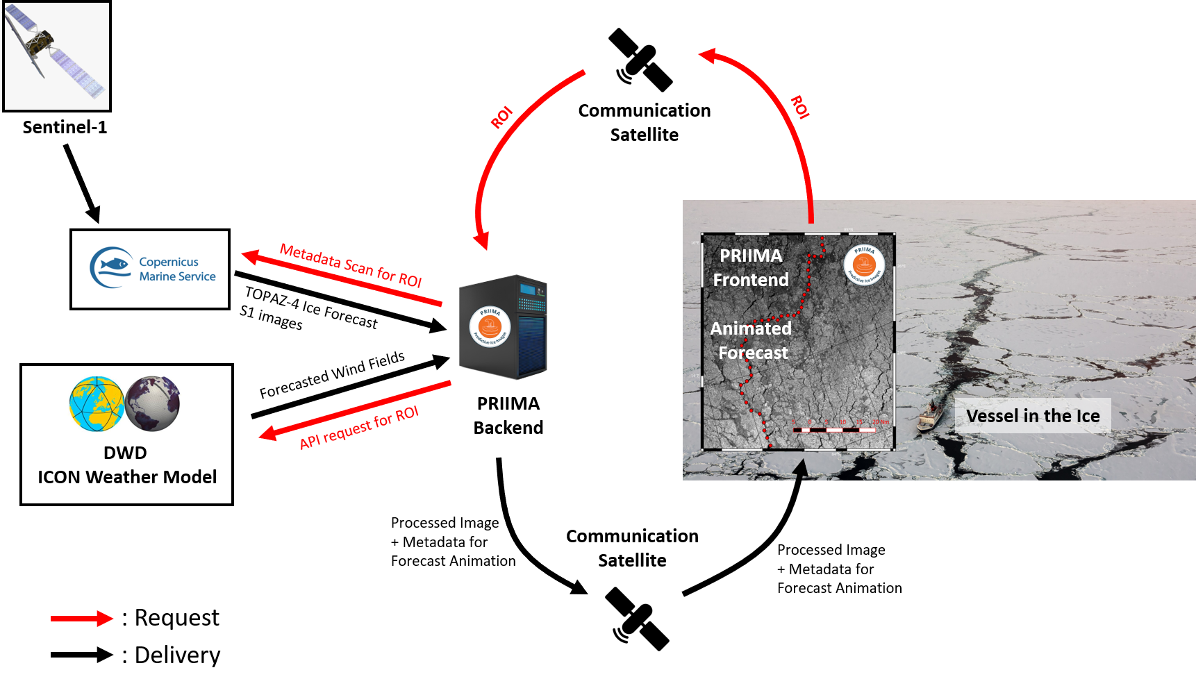
The operational loop starts with the request for a region of interest (=ROI) from a vessel in the ice via the PRIIMA Frontend. The request can be automated and is transmitted via satellite communication to the PRIIMA backend system. Based on the ROI several data sources are being scanned for suitable data. Main data sources are Sentinel-1 images and the operational ice forecasts from TOPAZ-4 distributed via the Copernicus Marine Service (CMEMS) and forecasted wind field distributed via the ICON weather model operated by the DWD. The PRIIMA backend system enhances the quality of the satellite image and attaches all the necessary information for the real-time and forecast functionality. Via satellite communication the enhanced image is being sent to the vessel in the ice and will then be animated and placed to its real time position by the PRIIMA front-end system.
Space Added Value
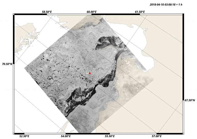
The most important information for PRIIMA is derived from Sentinel-1 SAR satellite images. PRIIMA increases the value of Sentinel-1 images by merging them with operational data from ice and weather models. PRIIMA basically adds a fast-forward functionality to Sentinel-1 images to visualize how features on the ocean, in this case sea ice, drift forward in time. PRIIMA solves a big data problem in the sense that it creates new information, namely high-resolution forecasts, by merging different space and non-space data. The animated gif image below shows an example.
Current Status
At the present stage (October 2018) we finalized the ESA Kick-start phase. During the project the major requirements for an operational PRIIMA system were defined and a development plan established. Service and system requirements were derived from user interviews and own in-field experience from icebreaker voyages in the Arctic. The principal technical feasibility of the approach could be proven (see animated gif above). The next logical step is to develop a PRIIMA demonstrator which can be tested in-field.