Objectives of the service
The proposed service aims to provide reliable and up-to-date flood insights at the property-level for companies and organizations in the wider real estate sector, such as real estate investment banks, property valuation companies, and ESG rating agencies. With the recent introduction of EU Taxonomy regulations, investors and companies are required to disclose the sustainability of their economic activities. Flood data plays a crucial role in assessing the environmental sustainability of a property (“E” part of ESG). However, currently available flood data is limited in geographical coverage, has low temporal resolution, and is not available on the property level. This makes it difficult for investors, banks, and private persons in the real estate domain to make informed decisions about investments and transactions.
To solve this problem, the service leverages the potential of Earth Observation data by using archived and current satellite images, such as Copernicus Sentinel, to produce dynamic flood hazard maps that are capable of keeping up with fast-paced climate change-induced variations of local flood patterns. This service fills the data gaps, reduces data inconsistencies, and saves effort, time, and money for the clients, by providing them with actionable flood information at the property-level through an intuitive web-interface and API.
Users and their needs
Targeted key market segments for the service are:
-
Banks
-
Property valuation companies
-
ESG rating agencies
Service/ system concept
The PROFEO service enables users to query cadastral parcels in Austria (specified by the Parcel number) through a web interface (interactive web map) or API. The response to the query is happening in real-time and includes the following pieces of information/answers to the questions:
-
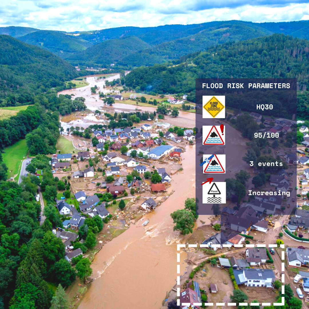
Official flood hazard data: In Austria, this corresponds to the modeled flood risk data provided by eHora. Is the parcel in a HQ 30 flood hazard zone?
-
Property level observed river flood frequency since 2015: How many times has the parcel been affected by a river flooding event (observed in satellite imagery)?
-
Property level relative river flood frequency (observed in satellite imagery) within a catchment? How does the flood event count of a specific parcel compare to all the other parcels in the same water catchment area?
-
Precipitation anomaly trend. Are there any trends visible in the occurrence of extreme precipitation and flooding events?
-
Per parcel data quality metrics / Confidence: How accurate are the results for the parcel of interest
The service combines different data types from various sources.
-
Satellite data: The service leverages the ESA Copernicus Sentinel 1 archive (from late 2015 onwards) to better quantify the flood risk on individual land parcels. The system uses satellite imagery (in combination with the meteorological data) and a tailored Machine Learning Model to count the number of observed flood events on each parcel. In this context, Sentinel 1 Synthetic Aperture Radar data are especially useful because they are daylight and weather independent and can “see” through clouds (in contrast to optical Sentinel 2 data).
-
Meteorological data: The PROFEO is using gridded precipitation data (available from 2011 onwards) for two purposes:
-
To focus the data processing on time frames around local extreme precipitation events and therefore significantly reduce the processing demand. The precipitation anomaly dates are extracted using a statistical model.
-
To derive long term trends in precipitation anomalies as an indicator for future local flood frequencies.
-
-
Other geodata: The service uses other freely available geodata as auxiliary input:
-
Water catchment polygons (vector data) as geographical unit to analyze precipitation data for extreme events and to derive trends.
-
Cadastral parcel polygons (vector data) as geographical unit for extracting property level information.
-
Historic flood maps (vector data) to validate results.
-
A block diagram of the service is provided below
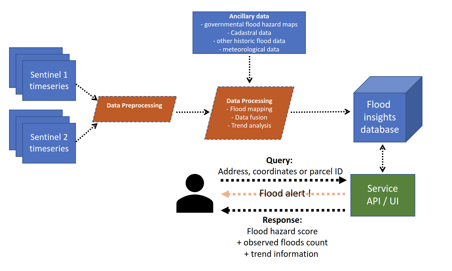
The precipitation anomaly extraction and trend analysis module uses catchment geometries and precipitation data as input and produces datelists covering timeframes around precipitation anomalies, which are the input for the following zonal statistics module. In this part of the processing chain, the Sentinel Hub Batch Statistical API is used to derive multiple statistical metrics from the Copernicus Sentinel-1 archive for each cadastral parcel (geometries provided via parcel geometries vector data) and timestep (potential flood candidates). The flood occurrence modelling module is designed to use the zonal statistics time series to check the potential flood candidates for flood observations. Finally, the relevant property level information is stored in a database, which is used by the web interface/API to deliver the results to the users.
Space Added Value
The service integrates the Copernicus Sentinel-1 Synthetic Aperture Radar (SAR) imaging mission as space asset to provide a snapshot of flood hazards at the property-level by analysing past and recent floods. Compared to the existing flood hazard data which are typically derived from groundwater and hydrological models, the service additionally incorporates observational data from Sentinel 1 imagery and gridded precipitation data to provide insights about dynamic flood pattern changes. Through the integration of existing flood hazard data and satellite image time series the PROFEO service is providing unprecedented flood insights at the individual property level.
Current Status
The service prototype has been successfully implemented and can be accessed under URL https://profeo.littlecode.com/
The prototype is now used to target potential customers in Austria and to implement the designed commercial roll out strategy.
Prime Contractor(s)

Subcontractor(s)