
Objectives of the service

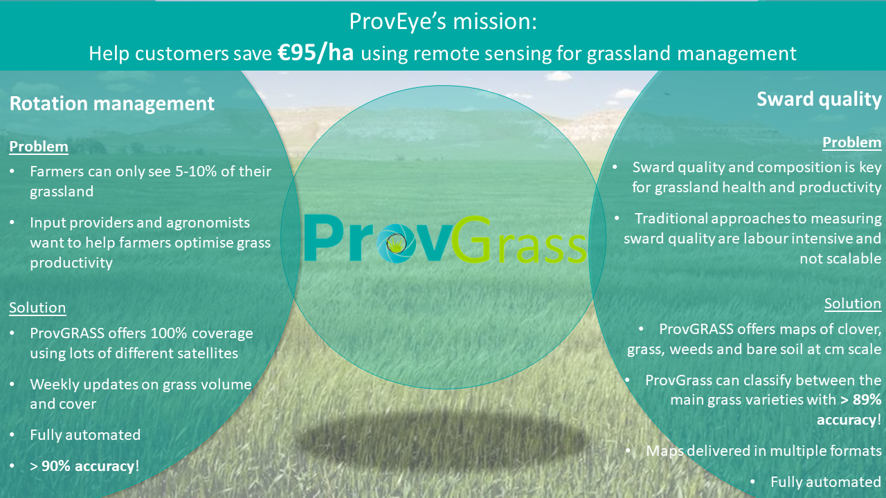
ProvGrass provides white labelled, multi-temporal maps of grass sward quantity and quality to enable customers to provide branded products for end-users related to grassland management. It has been estimated that improving grassland management can increase farm income by €94 per ha without using digital agriculture services. Grass is a notoriously difficult crop to measure over large areas. However, ProvEye have developed a method to provide unprecedent knowledge on the status of the grass sward. ProvGrass customers want to develop digital services for the grassland farmer. They have agronomic expertise but lack expertise in remote sensing and mapping systems. ProvEye will offer a value-chain partnership to acquire, process, interpret and deliver maps that can be packaged by our customers, using their domain expertise to sell as digital products or services to the end user (farmer).
Users and their needs
Users
Our customers are companies servicing the farmers who manage 4.1M ha of grassland in Ireland and 61M ha of grassland in Europe. Grass is the most important agricultural crop in the world, occupying about 70% of agricultural land. Our customers will include:
- Large agribusiness and farm management companies
- Agronomists
- Agrochemical companies
- Farm management software companies
- Bioenergy companies
- Traders
Customer Needs
High productivity grass management for rotational grazing dairy production (e.g., perennial ryegrass), biorefinery feedstock production (using speciality high protein varieties) and sustainable intensification (e.g., multi-species sward management), means farmers must know the change in quantity and quality of the grass over their whole farm weekly during the growing season. Our customers want to sell inputs, services and sustainable solutions, with a value proposition to farmers of increasing profits by optimising sward quality and quantity. A typical farmer only visits around 1% to 5% of their farm area by ‘field walking’ while remote sensing can provide 100% coverage. ProvEye is developing an end-to-end pipeline to allow our B2B customers to offer sward quantity and quality maps to the farmer, without any interaction with the raw data.
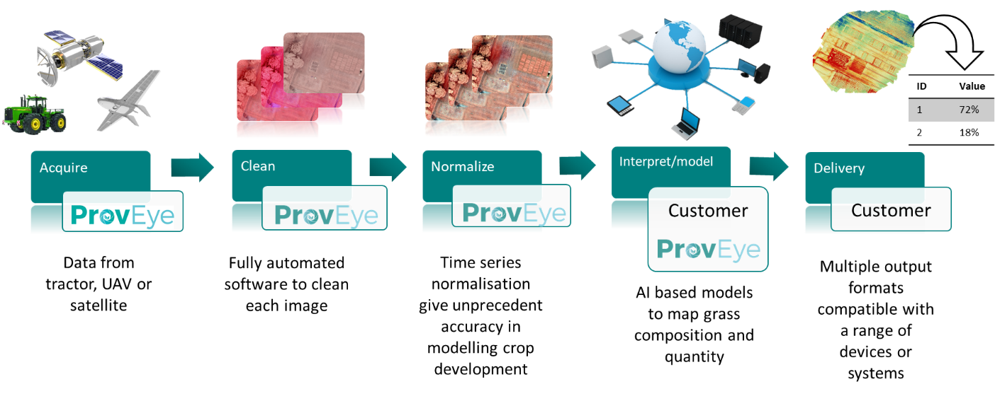
Service/ system concept
The cloud base platform will:
- Acquire optical images from various platforms, including vehicle mounted, UAV and satellite. The platform sensor agnostic so can use images from any optical sensor.
- Clean the images by removing radiometric and geometric defects using ProvEye’s advanced image correction software. Image mosaics will be created if needed, with advanced correction tools used to reduce variations within thew mosaic that would otherwise reduce image quality.
- Normalize a time series of images, when available, so that highly accurate biophysical measurements can be taken throughout the growing period of the sward. This technology is first to market for UAV data and ensures unprecedent accuracy in the final product.
- Model the data using AI/ computer vision-based algorithms that have been trained to detect the key constituents of the grass sward: grass, clover, soil, weeds as well as yield in DM t ha¯¹.
- Delivery of the final data can be formatted to the customers’ requirements. Full resolution geotiff images, tabular data, shapefiles, json files or xml file formats can be outputted. Our a more tailored format can be created in partnership with the customer, depending on their software requirements.
Space Added Value
ProvGrass uses Earth Observation and Satellite Navigation space assets to derive highly spatial and temporal resolution data about grass sward composition and quantity. ProvGrass will also allow fusion of UAV and satellite imagery to allow for leaf level information to be extrapolated over large areas. This is important for B2B customers that service tens to hundreds of thousands of hectares. Satellite navigation is used to ensure sub-pixel level georectification. This is critical at the plot scale when looking a time series data and change detection, as any spatial shift in the image stack will result in significant error in the final product. Multi-platform satellite data from various providers increases the likelihood of cloud free images over target areas. High temporal resolution image stacks are key for a dynamic crop like grass, therefore the <10-day revisit time is a crucial feature of the platform.
Current Status
The platform has just gone through its first testing phase through this Kickstart activity with remarkable success. The platform seamlessly integrates ProvEye’s core IP in satellite (ProvSAT) and UAV (ProvUAV) image processing to give unprecedented accuracy at any spatial scale and using any form of image sensor or camera.
The ProvEye team have engaged with a variety of potential B2B customers that are looking to either create or significantly enhance an existing advisory service for grassland management. These include:
- Seed and fertilizer companies
- Farm management providers
- Agronomists
- Dairy producers
- Beef producers
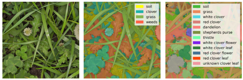
ProvGRASS achieved over 90% accuracy at detecting individual clover leaf’s, weeds, Perennial Ryegrass and bare soil using its advanced AI models in over 31600 images (figure 1).
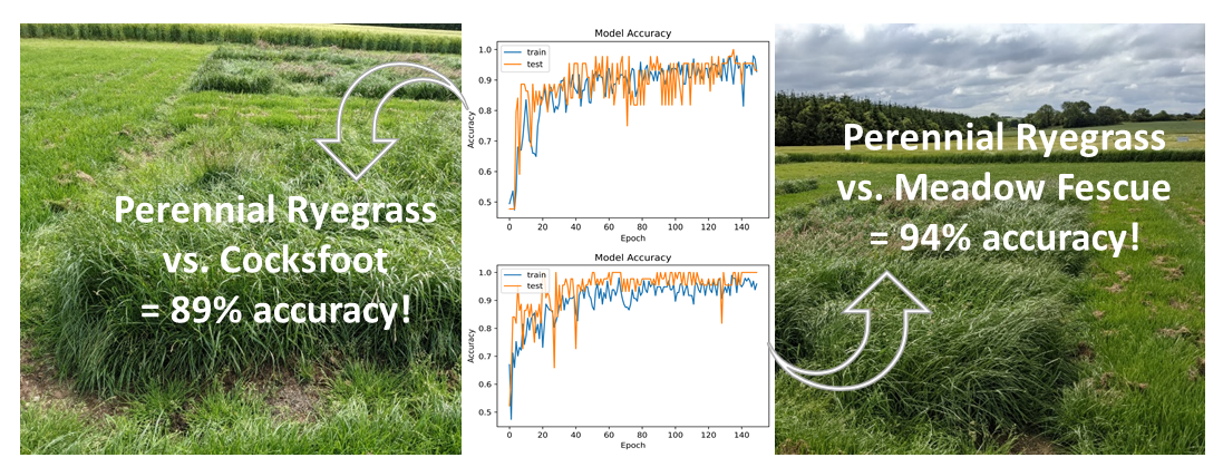
ProvGRASS was over 89% accurate in classifying between the grass species Perennial Ryegrass, Cocksfoot, Yorkshire Fog, Bentgrass, Meadow Fescue and Smooth Stalked Meadow Grass.
ProvEye have built the ProvGRASS platform around 2 core use case scenarios:
However the applications of ProvGRASS stretch well beyond grassland management to include:
- Environmental monitoring
- Grass quality assessment for the biorefinery industry
- Carbon modelling
- Compliance assessment
Future Plans
The ProvEye team will now build on the success of this Kickstart activity by validating the technical and commerical featues of the platform through a larger scale project. Additional features around biomass assessment and output delivery will also be exploured.
The final review of this Kickstart activity took place in October 2021, with a full commerical version of ProvGRASS is planned for release in the very near future!