Objectives of the service

Many satellite-based services in agriculture work on vegetation indices, linking the reflectance in different spectral bands to the surface properties. One good reason to do it in this way has always been that in situ data for calibration was expensive and difficult. The uprise of cheap sensors and 5G networks now provide new means to use the powerful spatial, multi-spectral, multi temporal aspects of satellite imagery in combination with quantified, geotagged sensor time series. Also, AI provides means to quickly absorb all these data into relevant information.
In Quantified Farm, we harness the powers of satellite data, sensor time series, AI and 5G to deliver a deepened experience for the data driven farm of the future. Our objective is to overcome the traditional issues with classical remote sensing-based solutions such as:
- Low spatial resolution in relation to the spatial characteristics of modern farm activities
- Interrupted time series due to clouds
- Inability to discriminate different causes of growth issues
- Using satellite-only data with models and algorithms, not designed for the farm of today
Our approach is to develop AI solutions on the fused sensor data from 5G sensor networks and satellite data. Our focus now is to unmix this information and precisely diagnose and indicate if crop growth is challenged by stresses from water, nutrients, diseases or other. This diagnostic approach provides farmers with better insights to make better data-funded decisions on what treatment to apply to what plot in the field.
For the farmer of the future, “Remote” Sensing is not necessarily so remote. Even the farmer can take advantage of satellite data, more than others, by integrating it with his on-farm sensor network. The currently deployed 5G networks provide means to get the sensor readings directly to data lakes where our AI algorithms provide near real-time analysis and decision support to the farmer of the future.
Users and their needs
The farmer is the key target customer and user of Quantified Farm. It is the farmer who decides if the crop will be irrigated or not. Quantified Farm will help the farmer to make these decisions with actionable advice based on a rich data set from multiple sensor modalities, multiple spatial / temporal resolutions, and state-of-the-art artificial intelligence models.
A few practical challenges that farmers face today are:
- Uncertainty of the exact state of their soils and crops (my farm is getting too big to regularly visit every plot of land as we did in ‘the old days’),
- A changing climate requires a different growing approach and to make decisions in areas that the farmer is not familiar with (which plot of lands needs irrigation first?),
- Legislation sets limits on the amount of fertiliser and crop protection agents (which part of the plot should be treated in what way to get the most out of it?).
Also, the agronomic advisor is a target customer and user. They can improve their advisory services with hard and relevant data, feeding powerful predictive models. Given the specialist nature of handling data and understanding its predictive value, the agronomist might even turn out to be an important influencer of the adoption of our service.
Service/ system concept
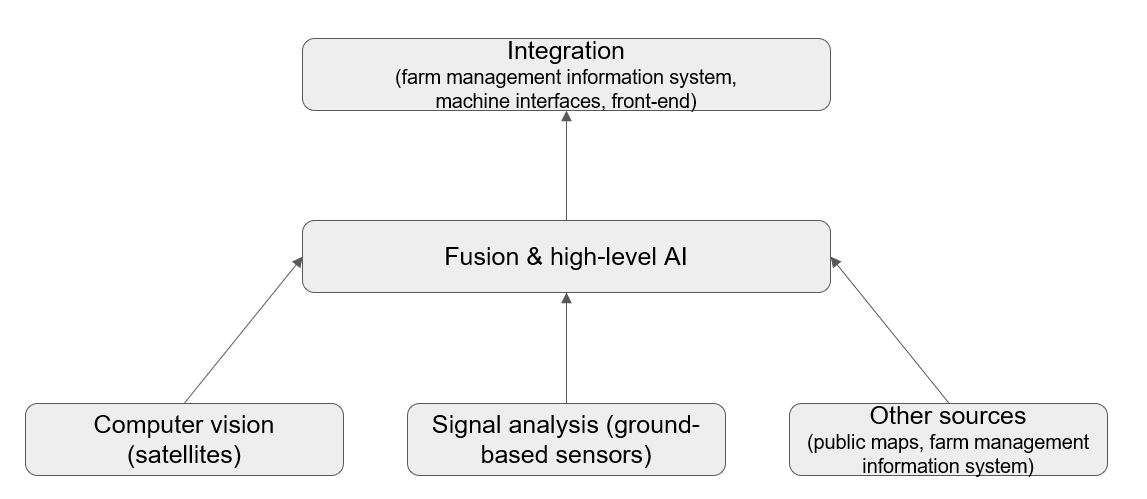
Farmers will use our Quantified Farm service as a decision support system, to receive warnings and to generate schedules and task maps for their machines working the fields. The technology to do this consists of multiple subsystems.

The computer vision subsystem digests raw satellite images, performs smart image pre-processing and analyses the images to come to usable geo-referenced information.
The signal analysis subsystem digests the raw input from the different types of sensors that are in the field. To get a real-time high data frequency even at remote regions, 5G networking is used. The signal analysis subsystem performs several data pre-processing steps and outputs ready-to-use geo-referenced information on this raw sensor data.
The fusion layer takes in all this information and combines it with other information from the farm management information system and public mapping services. Using AI and growth models it is able to support farmers in their crop treatment decisions.
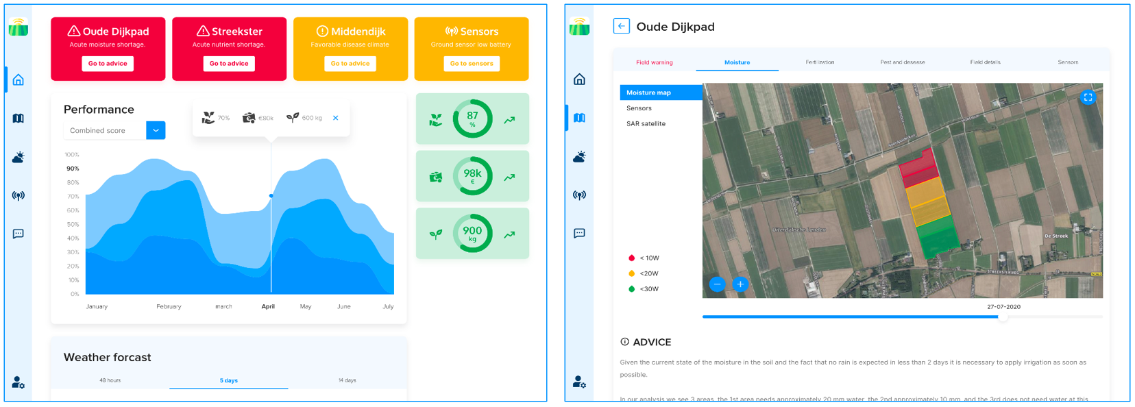
Finally, in the integration layer, the aggregated data and information, and generated warnings and advice are served to the farmer. The advice will be translated into schedules and task maps that can be used on their machines so that the farmer can take immediate action without having to be a data scientist. Below two screens shots are shown of the application. The first screenshot shows the dashboard of Quantified Farm with the warnings per field and overall KPI’s for the farm. The second one shows detailed information on one of the selected fields. In this example the composed moisture map is shown.

Space Added Value
Satellite technology will be used in two main forms: earth observation, and navigation. Regarding earth observation, satellite imagery will be used to assess the state of the crop (biomass, photosynthesis potential, nutrient levels and water content). Regarding navigation technology, GNSS is used for localization of ground sensors and agricultural vehicles (to enable variable rate application of fertilisers, pesticides, and water).
5G communication technology is used to connect the local soil/water sensors and weather stations to the data analysis server, and the positioning system of 5G will be tested for localization of the sensors. Another possibility for using 5G technology that will be investigated is for transferring task maps to agricultural machines to execute their precision tasks (e.g., controlling the nozzles of a spraying boom).
The key idea behind Quantified Farm is to fuse information gained from satellite imagery, with information gained from soil/water sensors, and super-local weather stations transferred via 5G. This leads to multimodal perception, enabling much more powerful and accurate models than before, with higher spatiotemporal detail.
Current Status
We have developed a Proof of Concept for Quantified Farm and are now working on a proposal for a follow up demonstrator project. Additionally, we are looking into the market conditions and business side of the project. A lot has happened since the beginning of the project in January 2020 and COVID 19 had a great impact on the business of potato farmers. This is one of the reasons why we are investigating if there are other stakeholders who can benefit from our sensor/satellite service. Water boards, or actually water managers in general, have shown serious interest in our solution. Managing surface and groundwater is an interplay between farmers and water managers. A solution that gives both parties a good insight can help in finding the optimal use of the resource water. During our Demonstration Project we will try to bring these two worlds together.
Prime Contractor(s)
Subcontractor(s)


