Objectives of the service
The development of RESUCI’s services is based on specific user needs that result from their daily activities.
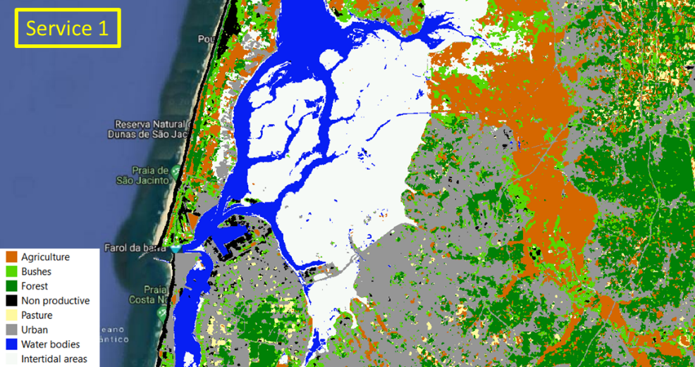
More specifically, the Right of way monitoring service considers that land use / land cover can greatly impact the safety of operation of liner infrastructures (e.g. high vegetation can prevent the normal functioning of high voltage powerlines or can represent an added risk in terms of forest fires).
As such, this service uses EO data (Sentinel 2) for the recurrent mapping and monitoring of powerlines protection corridors and interest areas, with the objective detecting in near real time, the areas which have a land use / land cover that can pose a high risk for the users’ infrastructures or surrounding environment.
This Service can stand as a de facto alternative to traditional methods (aerial photography and field visits) of characterizing and monitoring the right of ways of linear networks. It will provide
-
Faster updated characterization of the land use, when compared to traditional methods
-
Initial characterization of potential rights of ways at lower cost, when compared to traditional methods
-
Capabilities to analyse the evolution of the surroundings of critical infrastructures, helping on its monitoring and management
Below, an example of the service 1 outputs:
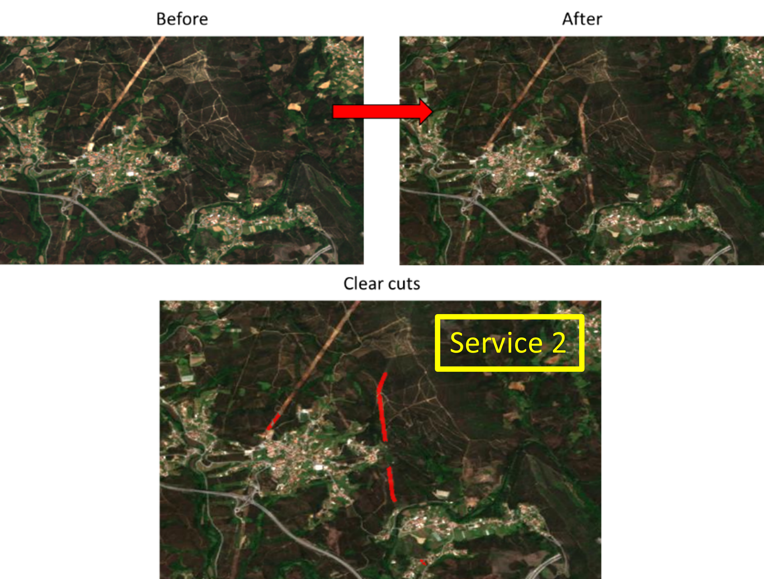
As for the Field maintenance operations management and control service, it uses EO data (Sentinel 2 images) together with semi-automatic and visual inspections, to perform continuous monitoring of the users areas of interest, to identify vegetation drops that occurred as result of field maintenance operations (clear cuts).
The service automatically detects and maps the decreases in vegetation between satellite images of different dates (before and after clear cuts occurrence), providing a tool for controlling third party operators that are subcontracted to perform these maintenance tasks.
Below, an example of the service 2 outputs:
Users and their needs
The users of RESUCI’s services are typically responsible for the management of linear networks (Rights of Way - RoW). These linear networks can stand as critical infrastructures per se (e.g. as defence for forest fires) or can be used for the safe operation other types of critical infrastructures such as powerline networks.
As of today, traditional methods (helicopter, drones, UAVs, etc.) are used for monitoring and mapping the right RoWs for the detection of obstacles and activity that can pose any risk of threat.
In the framework of RESUCI, two services based on Earth Observation imagery were implemented and provided a set of improvements when compared to the typical methods. These services address common needs:
-
Land use categorization for initial characterization or definition of new segments in forest defence networks.
-
Reclassification of risk areas according to land use for operational risk management
-
Validation of post-intervention maintenance operations in the framework of the regular activities
-
Provision of evidences that may be used as proof to third parties, if necessary.
The users of the services were
-
REN - main Portuguese power distribution company
-
ICNF - Portugal’s Nature and Forest Conservation Institute
Service/ system concept
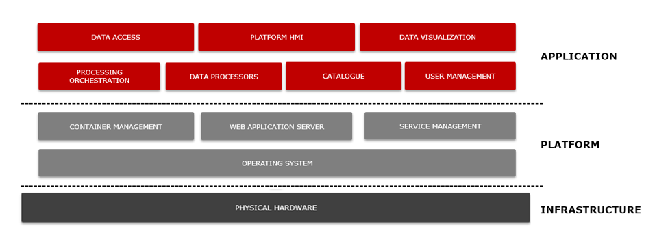
The services have been implemented via a technological platform for data processing and output dissemination. This platform is composed by a set of software components integrated together which run the RESUCI services automatically, providing the users with outputs at pre-defined intervals.
The figure below illustrates the system logic – EO data is used, together with any ancillary data available, as inputs for two processing chains (services 1 and 2). The system then outputs geographic data (various possible formats) that are made available to the project users.
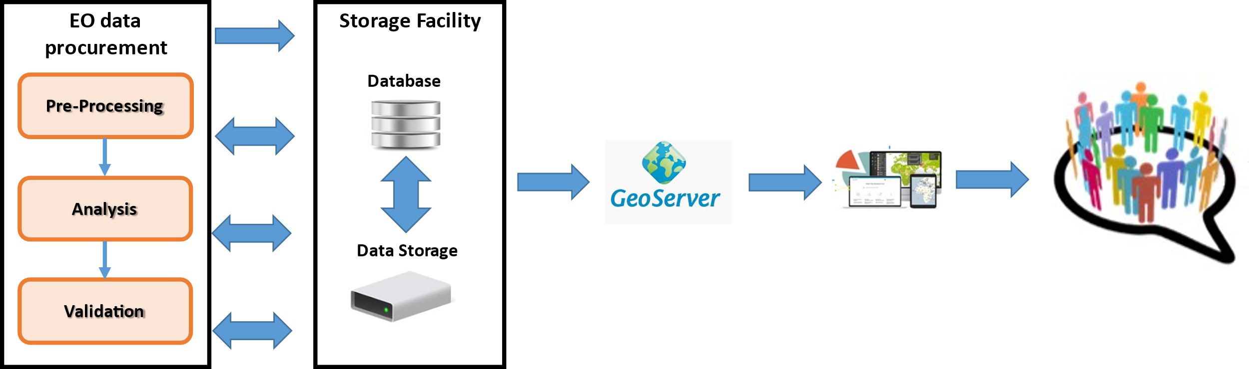
The core functionality of the RESUCI system includes:
-
Data Management - to retrieve, store and manage the data used in the platform
-
User Management - the platform is multi-tenant that means that provides isolation of data and users groups, leveraging its usage for different projects and activities
-
Data Visualization - geo-located outputs and geo-referenced images are possible to overlay on top of maps and presented to the user through specific geospatial information tools
Space Added Value
The RESUCI services are based mainly in Earth Observation imagery, as they offer a number of benefits:
-
Products in different spectral bands (electromagnetic radiation) in addition to the information that is visible, which makes it possible to study in detail certain chemical and physical properties of objects
-
Possibility to generate multispectral compositions from spectral bands (e.g. NDVI, EVI) allowing to understand relationships between the different components to be analysed and the surrounding landscape
-
Ability to obtain data at a distance, without the need to move teams on the ground, as well as to acquire such data on remote or inaccessible regions
-
Possibility of temporal analysis, allows monitoring of changes occurring in the places of interest, as well as the ability to analyse data from the past
-
Digital image processing allows the production and analysis of results in a fast and automated way
-
Reduction of monitoring costs when compared to traditional monitoring methods (e.g. field work, helicopter surveys).
Current Status
RESUCI DEMO is now on its final stage.
Both services have been provided in an operational environment during the project’s pilot stage and now the general results are being analysed to identify gaps and improvements that are needed.
The acceptance of the services was quite high and discussions for commercialization of the services are on-going with one project user.
Prime Contractor(s)

Subcontractor(s)