Objectives of the service
Rural Tourism 5.0 (RT5.0) is a next generation travel planning ‘eco-algorithm’, designed to improve the visitor experience, impact on the environment, and the economic output of rural tourist destinations.
The new technology embraces an “attract and disperse” agenda, with the aim of spreading demand across visitor attractions, accommodation, and food and beverage merchants without diminishing existing levels of business. Developed over 2 years, including a 6-month visitor engagement program during Spring and Summer 2024, RT5.0 encourages people to shift to public transport, creating significant environmental benefits for residents and visitors by reducing traffic noise and air pollution.
The project also focuses on understanding and mitigating the effects of ‘fly parking’ (parking in undesignated roadside and off-road areas, especially at popular holiday times) which causes further problems for communities, businesses, and visitors alike, by affecting access to towns, villages, and visitor attractions.
The potential financial return on investment could be significant. The UK government acknowledges that developing rural tourism and supporting services is key to long-term economic and social welfare. It’s estimated that the north and southwest of England account for 23% of the UK tourism economy, generating £21.7bn in 2018. To successfully boost growth and overcome tourists’ perceived dependency on travelling by car, which was compounded by the pandemic, there is a collective desire to create more engaging ways of enhancing visitors’ overall experience. Understanding the pressure on access points to areas of outstanding natural beauty and helping visitors to enjoy points of interest without creating pinch-points and bottlenecks is integral to the project.
Users and their needs
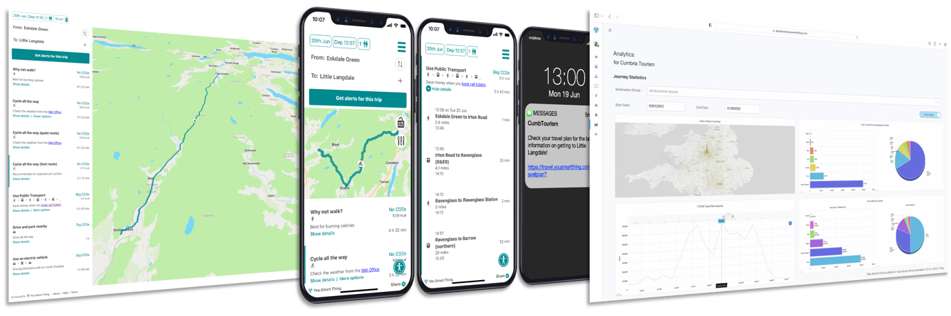
As part of the RT5.0 project a web-based travel assistant application was commissioned for use by visitors to two of the UK’s leading tourist destinations, The Lake District and Cornwall. The travel assistant promoted recommended routes and low-carbon travel plans, including public transport itineraries that also incorporate cycling and walking.
Balancing Growth with Environmental Sustainability
Providing viable family friendly multimodal choices, and nudging tourist behaviours towards active travel to and from rural destinations, has the potential to dramatically reduce the sectors carbon footprint. Stakeholders believe the space enabled RT5.0 travel assistant service can help manage increasing demand, alongside maintaining the biodiversity and attractiveness of the natural environment. In this way, RT5.0 is expected to help balance environmental sustainability with economic growth, benefiting visitors, host communities, and the planet.
Service/ system concept
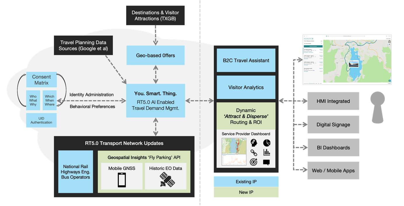
The service was easily embedded in websites and could be linked to from marketing communications and promotional collateral. Uniquely, it addressed the issue of fly parking using data from satellite imagery as part of a new eco-algorithm, designed to help reroute visitors around congested hotspots and redistribute peak-time demand by promoting viable alternatives to travelling by car.
The system architecture, outlined below, combined Earth Observation data with mobile satellite navigation data to create a predictive model that indicated likely times and dates when access roads might be nearing capacity. This indicator then fed into the eco-algorithm, which applied business rules to optimise the dispersal of visitors in the most sustainable and economically viable way.
Space Added Value
The use of space-based technologies, including historic Earth observation satellite images and data from newly sourced Synthetic Aperture Radar (SAR) images, helped to continually enhance the RT5.0-enabled routing algorithm, offering visitors travel options that were optimised to support regional environmental and economic objectives. This represented a significant shift in the purpose and utility of travel planning services.
Optical satellite imagery was provided by a range of optical satellite providers, including Airbus, Planet, Maxar, and BlackSky, where possible and appropriate. Archive imagery was employed to analyse past parking behaviours, while new acquisitions were implemented to monitor known problem locations.
Satellite imagery was used in parallel with mobile data throughout the project. While satellite imagery provided a comprehensive snapshot of traffic and parked cars at a specific moment in time, its frequency was limited, creating gaps in the overall picture. Mobile data offered a continuous stream of information, but its availability was restricted to approximately 10% of the total population, making it insufficient for predicting congestion in isolation. The project utilised both data sources to generate a continuous stream of information, modelling the total volume of traffic and congestion at a given location.
Current Status
The Rural Tourism 5.0 (RT5.0) project has successfully showcased how space-based technologies, including satellite imagery and AI-driven analytics, can be harnessed to enhance sustainable tourism travel, improve visitor experiences, and boost regional economic benefits. By integrating low-carbon travel recommendations with predictive congestion management, RT5.0 introduced a new approach to tackling key tourism challenges such as fly parking and over-tourism in rural destinations, specifically in Cumbria and Cornwall.
Led by You. Smart. Thing. (YST) in collaboration with Geospatial Insight (GSI), Cumbria Tourism (CT) and Visit Cornwall (VC), the project brought together expertise in intelligent mobility, geospatial data analytics, and regional tourism management. The project focused on providing a scalable, data-driven solution for managing visitor flow, optimising public transport use, and mitigating environmental impacts. The project successfully deployed a web-based travel assistant, integrated with satellite data and predictive algorithms, enabling visitors to make informed travel decisions while supporting local authorities in proactive traffic and visitor management.
The RT5.0 pilot revealed several key insights and challenges. One of the major milestones of the project was the integration of satellite imagery data to monitor parking behaviours and likely congestion hotspots. However, limitations in satellite frequency and cloud coverage required supplementing the system with mobile data to ensure comprehensive 24/7 coverage over the 6-month testing period. Additionally, the initial reliance on visitors selecting specific destinations for RT5.0 enabled route planning did not generate sufficient data, prompting a strategic shift to also capturing through-traffic movements in the monitored regions. This adjustment significantly improved data collection and provided more accurate insights into regional travel patterns.
To measure its success, RT5.0 set Key Performance Indicators (KPIs) across environmental sustainability, visitor experience, economic growth, and operational efficiency. During the trial period (September–November 2024), the project delivered strong results. The parking identification model achieved 80% accuracy, demonstrating its potential for effective parking management, with further refinements planned for continuous improvements. Visitor numbers increased by 13.31%, exceeding the initial 10% target, highlighting the project’s positive impact on regional tourism. Sustainable travel was successfully encouraged, with a 23% rise in cycling, 5.3% increase in public transport use, and 3.23% increase in walking, alongside a 7.13% drop in private car usage.
Overall, RT5.0 has proven the value of space-enabled technologies in rural tourism management. By improving travel efficiency, reducing environmental impact, and creating a smarter, more sustainable visitor experience, the project has laid the groundwork for expansion across other tourism regions. With continued development and refinement, RT5.0 has the potential to become a transformative tool for smart tourism and regional mobility management worldwide.
Prime Contractor(s)
Subcontractor(s)