Objectives of the service
The overall context of the project is given by the increasing importance that is given nowadays to a good development and management of green areas in urban environments, taking into account their impact on environmental factors and implicitly on inhabitants wellbeingș.
In recent year several initiative at all levels from global to local have been focusing on promoting a good integration of green infrastructure in urban planning. A major drawback that was identified during these programs consists in the absence of common data collection and sharing methods that are easily scalable.
A viable solution for supporting this type of actions is represented by space-based data, wich is widely available, assuring a spatial and temporal that can be in line with the current requirements of key stake holders in the field of urban planning and decision making.
Objective: S4UG is a fesibility study that aims to demonstrate the technical feasibility and commercial viability of Earth Observation based services addressing design, planning and management of urban green infrastructure.

Users and their needs
Main stakeholders involved in the definition of User Requirements (URs) and the development of Use Cases, are representatives of the Bucharest authorities from District 2, District 6 and Main City Hall. These institutions were selected considering the ease of organizing a scalable use case in Bucharest.
Other relevant users coming mainly from the Urban GreenUP Network of cities. Users have been targeted through the review of documents, interviews and questionnaire based surveys.
In the figure below there is a graphic representation of the spatial distribution of the users that responded positively to our invitation through either participating in interviews or responding to questionnaires.
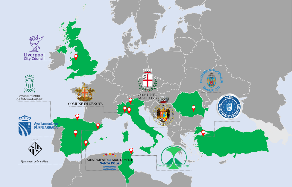
The spatial distribution of the consulted users
Identified user needs:
-
Interoperability with GIS services;
-
Taking into account environmental factors when planning new green spaces;
-
City level monitoring system for preventing illegal changes of the land-use destination from green spaces to constructions;
-
Monitoring the alignment of newly built residential complexes to the imposed quota of green spaces per occupied sqm.
-
The best way of delivering the services would be through a platform where the user could either make interrogations on the data or download the data in the desired format to further be integrated in decision tools;
-
Soil quality is one important aspect in monitoring vegetation health and planning new green spaces;
-
Insights in the historical evolution of the urban area in relation to vegetation and environmental factors;
-
Information on population proximity and accessibility to new green spaces being developed
-
Management of urban heat islands through planning of urban green infrastracture
Service/ system concept
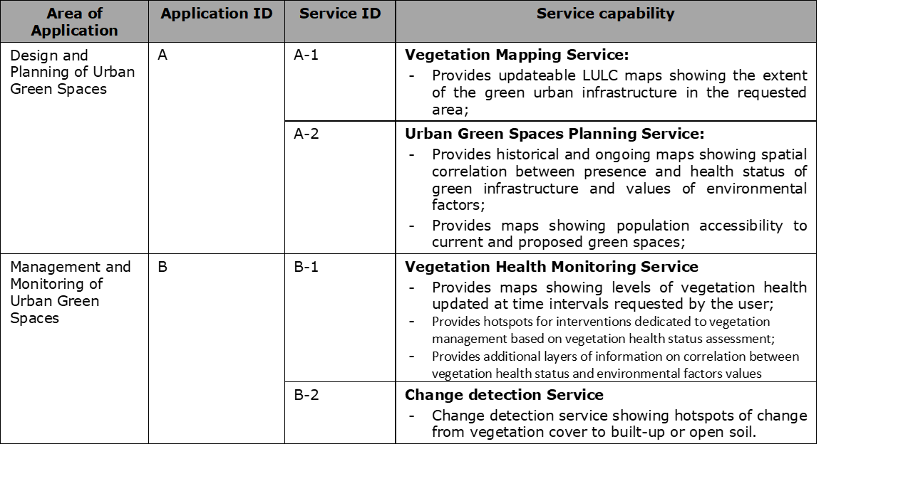
Services proposed are:
-
Application A – Design and Planning of Urban Green Spaces
-
Application B – Management and Monitoring of Urban Green Spaces.
Each of this application is further subdivided into potential services which in turn satisfies a group of end user requirements. An overview of this subdivision is given in the table below:
Space Added Value
Satellite imagery is used as the main source of raw data for the both applications. Mainly the services are built on free and open source imagery derived from Copernicus constellations such as Sentinel 2 (Multispectral Instrument, MSI) mission. The mission provides a rich raw data stream with a high spectral and temporal resolution allowing an enormous coverage. Services developed to make use of these datasets enhance the spatial resolution of the delivered products (<10m) through super-resolution techniques and will be scalable to cover vast areas of interest. Furthermore, advances in computer vision are pushing the boundaries as to what can be achieved with this data.
Some application will likely require Very High Resolution (VHR) imagery, so the service proposes provision of synthetic VHR imagery while avoiding a substantial increase of the cost of implementing the services. One application which is often favourable is to use a hybrid of Sentinel and VHR imagery. The end user could be presented with an image acquired from Sentinel 2 (10 x 10m pixel) of an area of interest, and then given the option to upgrade the resolution for a fee.
. At the user-end, the added value of the services will translate into:
-
Understanding the change patterns of the urban area with a focus of green infrastructure extent;
-
Understanding of how historical change patterns correlated with changes in the green impact indicators;
-
Deploy warning systems in case of anomalies in the temporal signature / if the vegetation coverage percentage is dropping too much with respect to the built up area in a patch / high values of environmental indicators.
-
Masks of identified areas in need of more green areas.
-
Assess green spaces accessibility based on correlation between census data and derived LULC maps;
Current Status
The project has started with a first requirement gathering phase where the views and needs of users have been attended and understood. From a qualitative description of the problem, service specifications have been derived and technicalities described. After some fine tuning of the concept, service mock-ups became ready for implementing first demonstration proof of concepts. They synthesize and condensate all the knowledge and experience learned so far along project lifetime and provides the material to approach users with potential ideas of pilots. A new round of meetings has served to freeze service concepts and run a market analysis to base a business plan. The plan accounts for two differentiated domains: 1) how the services connect with the surrounding market environment with a description of clearly defined opportunities, and 2) how the services can be implemented, operated and exploited in a long-term business continuity strategy that enforces the commitment of different user sectors beyond the management of urban green infrastructure managers.
Prime Contractor(s)