
Objectives of the service
Meeting the EU’s ambitious 2050 Net Zero target presents a considerable challenge for the Buildings and Energy & Utilities sectors. Leveraging space-based solutions and access to real-time data, offers a promising avenue for enhancing decision-making regarding greenhouse gas (GHG) emissions reduction. However, the effectiveness of these solutions depends on the availability of relevant space data and the development of innovative downstream applications, enabling technologies, and pioneering concepts to generate data that can be transformed into actionable intelligence for users.
The project aimed to develop a comprehensive action plan for maximizing the potential of space-based solutions in supporting the transition to a greener economy and decarbonization in these sectors. This involved:
-
Defining user requirements.
-
Identifying opportunities for the space sector to address key user requirements.
-
Defining space-based concepts to address these user gaps.
-
Evaluating these concepts for technical and economic feasibility.
-
Outlining implementation roadmaps to take the concepts to market.
The project addresses two primary challenges. Firstly, it identifies cutting-edge novel space-based technologies, existing, planned and potential, capable of addressing the specific data needs.
Space-based technologies capable of producing relevant data/intelligence.
Solutions possessing raw data but requiring additional processing and analysis (e.g., modelling) for generating relevant insights.
Emerging solutions with the potential to provide relevant data in the future.
Secondly, the project has evaluated the viability of bringing emerging solutions to market from both technical and economic perspectives.
Users and their needs
Who are they?
Target users encompass firms within the EU Buildings and Energy & Utilities sectors, seeking solutions for further reducing GHG emissions.
What do they need?
These users require high-quality, real-time data to refine their GHG abatement strategies and space-based solutions hold promise in fulfilling these data requirements.
Requirements selection
The project focused on a smaller set of significant use cases, established by the following criteria: impact on decarbonisation, the space-based technology gap, and the prevalence of the requirements from conducted stakeholder interviews. The follow 3 use-cases were selected:
Buildings sector
-
Use-case 1: Digital Twin model for city planners to support urban development.
-
Use-case 2: Data to measure energy performance of buildings and prioritise retrofitting.
Energy & Utilities sector
-
Use case 3: The remote detection of water leaks.
Service/ system concept
For each of the use-cases selected, the various segments (space, ground, user, etc.,) were clearly defined with their technical characteristics. A technical roadmap was also compiled.
Use-case 1: Digital Twin model for to support urban development
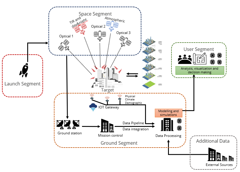
This solution requires a new satellite constellation that provides high-spatial resolution stereo-optical images to capture and derive building footprints and rooftop & façade material, accompanied by high resolution LiDAR data for height estimation for accurate 3D city model generation. Data collection is required at a very high resolution and frequency (once a week), with TIR data at 2m to 5m spatial resolution.
Use case 2: Data to measure energy performance of buildings and prioritise retrofitting
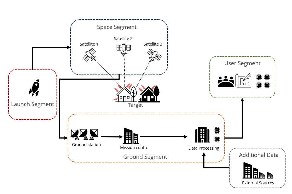
Similar to use-case 1, this mission is built to assess energy efficiency of buildings from space, using three different payloads – RGB, VIIRS, MWIR- mounted together on three satellites with different viewing angles. Additional processing and data sources are needed to develop a comprehensive understanding of a building’s energy efficiency, alongside data collection at very high resolution and a monthly frequency.
Use-case 3: The remote detection of water leaks
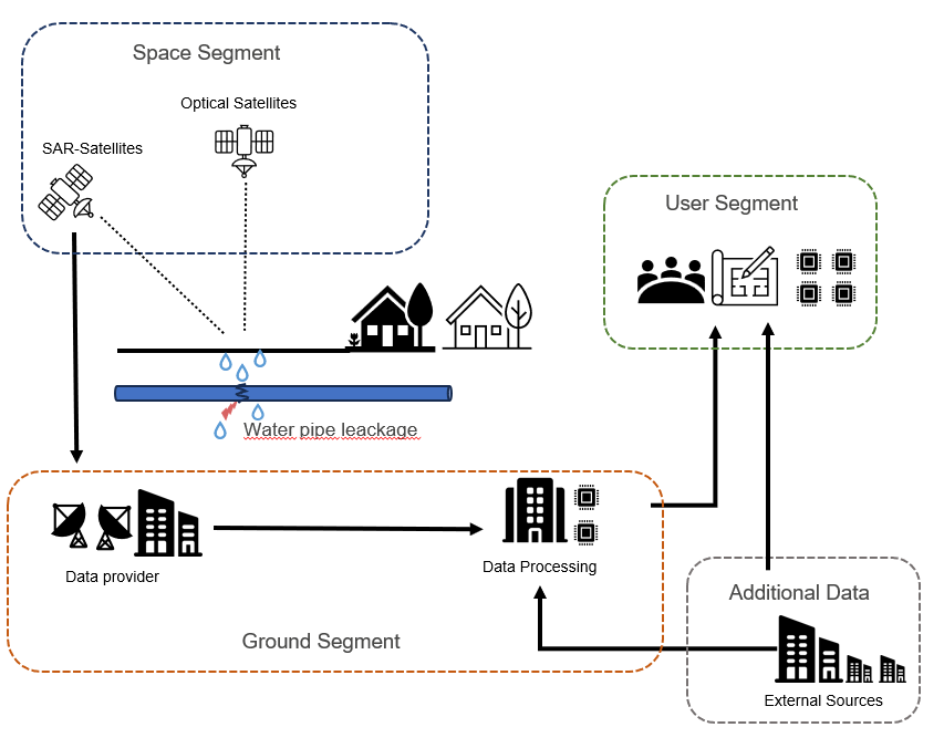
This solution can be brought to market by using existing space infrastructure, specifically those with SAR sensors that address the user requirement of 5-10m and global coverage. Development of an algorithm would be required to address the use-case alongside additional data such as weather measurements, and geographic maps of water pipe infrastructures.
Space Added Value
The asset categories that are in scope of the assessment of current and planned space-based technologies against user needs, and potentially of the set of technical concepts and roadmaps for future implementation are:
-
SatCom
-
SatEO
-
SatNav
Current Status
Project conclusion
Following the analysis, a conclusion was made on the overall commercial viability of these solutions. The study found that:
-
Solutions involving dedicated satellite infrastructure to address single use cases, such as the Digital Twin (use case 1) and Energy Performance (use case 2), are not commercially viable on their own. These solutions involve significant upfront investment and are underutilised when limited to a small group of users in a limited geography. This limited customer base makes it difficult to recoup capital at a price point that the market can bear
-
However, early adoption of these solution can be justified for the socio-economic impact that they can have in reducing carbon emissions.
-
Solutions involving limited capital expenditure, such as the solution to address the water leak detection use case (use case 3) can achieve commercial viability under certain circumstances.
-
Solutions could achieve commercial viability by expanding the geographical reach beyond Europe and addressing multiple use cases within a unified satellite constellation. User requirements analysis reveals a significant overlap, suggesting a potential for a minimum viable architecture.
-
Relaxing some of the stringent requirements (revisit times, stereo imagery, and high thermal imagery) and exploring Commercial Off-the-Shelf (COTS) subsystems merits further examination to reduce overall solution costs.
-
The project adopts a ‘build’ strategy for use-cases 1 and 2, but governments and institutions may wish to consider a ‘wait and buy’ approach, supporting emerging solutions through co-investments or data procurement. Balancing cost-effectiveness with timely action is essential for decision-makers assessing technological solutions for societal issues.
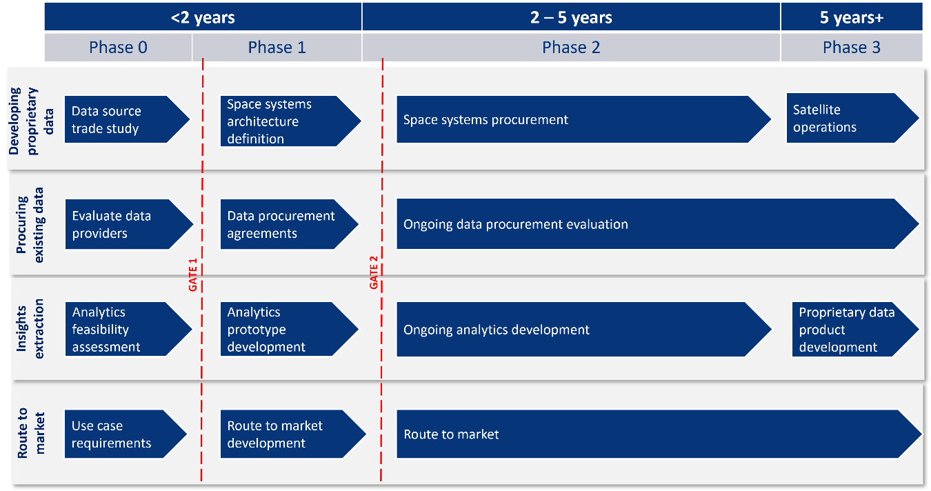
Roadmap development
A roadmap for the development and build of the solutions is suggested to prioritise the project’s activities, optimise the trade-off between solution performance and cost, , and decide between new solution development and procurement of existing solutions.
The proposed roadmap adopts an iterative development approach, with activities that determine overall feasibility front-loaded to optimise resource spend. The roadmap involves 4 phases (Phase 0 to Phase 3) and adopts the following broad approach:
-
A broad feasibility study (Phase 0) to explore all possible technical options given the current state-of-the-art.
-
Early engagement with stakeholders to ensure that any envisaged benefits can be realised and identify use cases that could support any investment.
-
Seek to address as many of the use cases through existing EO sensors to enable benefits to be realised earlier than wating for new sensors to become available.
-
Developing the processing and analytics chain as early as possible, and before any new sensors are created. This ensures that engagement is carried out with users before committing large investments in new EO sensors, with opportunities to refine the technical specification in line with evolving user requirements.
Figure 5 presents the activities necessary across the four workstreams for product development. Gates serve as review points, facilitating an assessment to ascertain the alignment of progress with scheduled activities.
Prime Contractor(s)

Subcontractor(s)