

Objectives of the service
The key objectives of SAFEDEM are:
- to bring satellite technologies in the Mine Action context, where up to now they are only partially exploited;
- to consolidate a methodology for integration and fusion of Satellite, RPAS and land based data aimed at providing support to Land Release activity;
- to demonstrate and deliver to Mine Action users some well-established data processing techniques;
- to set-up a set of innovative services in a coherent framework, in order to help Mine Action practitioners in their activities.
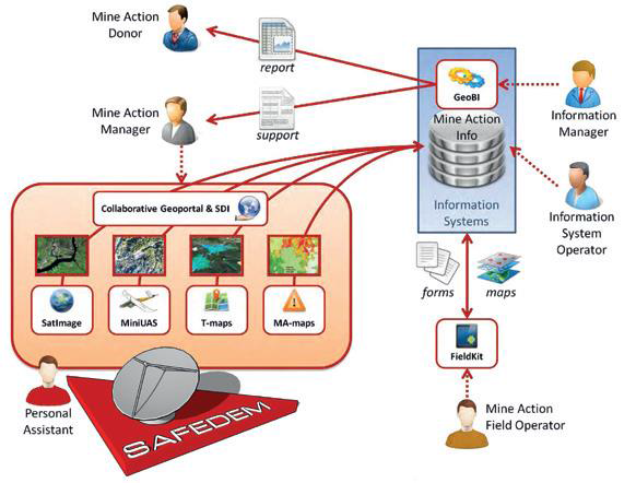
SAFEDEM provides service products addressing the needs of the Mine Action community to improve and optimize planning and preparation, and to assess/monitor the impact of emining activities.
SAFEDEM service products integrate data from Earth Observation satellites with high-resolution data acquired through Remotely Piloted Aircraft Systems (RPAS) to offer a comprehensive set of products and services in support to land release process in mine action at its various levels. Products are accessible through a Geoportal, allowing their easy visualisation and managing.
The SAFEDEM Demonstration Project is the follow-up of the SAFEDEM Feasibility Study which demonstrated the capability of space integrated assets to provide useful information for the demining activities confirming the potential to provide sustainable services with measurable benefits to the mine action community.
Users and their needs
SAFEDEM land release services are relevant for the following main user segments:
Mine Action Centres (MACs): responsible for the day-to-day coordination of the national mine action programmes of a country, coordinating the field work of the various accredited organisations and agencies (NGO, UN, bilateral agencies or commercial contractors). MACs activities are organized in multi-years (3 to 5 years) work program financed by donors and national funds.
Non-Governmental Organizations (NGOs): in charge of implementing mine action programmes (particularly in the areas of risk education, clearance, survey and victim assistance) and to build indigenous capacities to respond to the consequences of landmines. NGOs operate in different countries, on the basis of calls and contracts with a short temporal horizon (2-3 years).
Main need: geo-referenced information management and processing in support of land release, in particular during technical survey and clearance phases.
Field operators need timely, accurate and reliable mapping of suspected hazardous areas, including thematic layers describing the field situation and changes over time.
Interoperability with existing and upcoming solutions is also a need: solutions should be built on or interoperable with existing tools & systems (such as with VHF/HF/mobile phone, etc.), and be operable and maintainable by local staff who require minimal infrastructure and training.
Users involved in the project:
- Bosnia & Herzegovina Mine Action Center - BIHMAC
- Swiss Foundation for Demining/Fondation Suisse de Deminage - FSD
- Tajikistan Mine Action Centre - TMAC
- Armenia Mine Action Centre - ACHDE
Stakeholder: the Geneva International Center for Humanitarian Demining - GICHD.
Support to the project activities dissemination was provided also by the Italian Ministry of Foreign Affairs- Agency for the Cooperation and International Development.
Service/ system concept
The SAFEDEM demonstration project portfolio consists of the following services:
- Field Survey Services provided by SatImage and MiniUAS that provide satellite images and/or field survey data.
- Value Adding Services: these services, Thematic maps and MA Risk maps, are built on the output of the “Field Survey Services”.
Services are distributed through the platform Geoportal.
Services are provided on demand, based on existing data and on-purpose surveys, through user-friendly interfaces and a competent help desk, in collaboration with existing services.
SAFEDEM services are expected to:
- provide the mine action community with timely, accurate, easy to find and select, and cost-effective stand-off raw data from space- and air-borne sensors;
- offer data processing and interpretation assistance to obtain standard and customized thematic maps (e.g. DTM/DSM, land cover, land use, change detection, geolocated user information such as accidents);
- build on thematic layers to obtain maps of indicators relevant to mine action assessment (e.g. conflict-related: craters, trenches; objectives of mining: paths, infrastructure; destroyed/unused building, etc.) and hazard maps, useful for prioritization and planning, as well as post-clearance assessment impact maps.
Space Added Value
Space-based remote sensing allows fast large-area coverage independent of accessibility of territory, and archival records are available for pre-/post- conflict comparison.
Earth Observation data is required to identify indicators of mine absence and presence for land release planning, and to regularly provide updated information on land use and land change, which is used in support to post clearance survey activities.
The SatImage component provides historical and updated ready-to-use satellite images. The service searches and identifies satellite data from providers to fit specific MA customer needs.
Airborne/RPAS imagery effectively integrates with spaceborne sensing, providing high resolution data targeted to areas selected based on satellite image analysis. Mini-Unmanned Aerial Systems for acquiring high-resolution imagery over suspected environments provides on-demand customized service to perform very high resolution image acquisition over a hazard area exploiting high spectral and spatial resolution imaging systems (RGB, IR, Thermal, LiDAR) for accurate and repetitive area survey.
GPS is used to optimally control the flight path of the RPAS and to subsequently georeference its imagery for further processing.
Remote sensing data interpretation and management tools, developed in the space assets environment for many and diverse applications, are already available and allow to provide Thematic maps and MA-Risk maps for planning and decision, including land use maps, change maps (in particular pre-/post-conflict, pre-/post-clearance), disturbed terrain analysis, human activity maps. They are produced by integrating and fusing existing satellite images and MiniUAS products via interpretation and classification.
Current Status
Mine Action Centres, located in areas affected by mine remnants, and the entities (NGOs, private companies) in charge of conducting the clearance activities to release areas need to:
- get cartographic and geo-spatial information on un-explored areas, in any region of the World, for the first phase of Mine Action (non Technical Survey)
- get historical data about the same areas on land use and its changes
- prioritize the areas of on-site intervention (Technical survey, clearance...)
- integrate ground truth information (e.g. accidents...) and maps on a Geographic Information System (GIS)
e-GEOS and the SAFEDEM team carried out the SAFEDEM demonstration projects with end-users (demining NGOs, international and national authorities) in order to provide remote sensing products suitable to support their action.
Even if any information has to be carefully verified with on ground survey, it turns out that Remote Sensing imagery (from satellite to RPAS) and derived products (thematic maps) are very useful to shorten the operational time for non technical survey (the first and most time consuming phase of demining action).
In addition, the analysis done with SAR (Synthetic Aperture Radar) time series of data provides information about human presence and activity in the surveyed areas, thus supporting risk assessment and prioritization of intervention areas.
All geospatial information are then integrated with “ground based” historical records in a GIS based spatial model to evaluate the map of mine risk associated to an area.
The project development phase ended in 2014, followed by the validation phase supported by the project end users, BIHMAC, TMAC, ACHDE. The techniques developed and demonstrated within the SAFEDEM Project allowed to enrich the overall security service portfolio of the participating companies. In particular, the fully exploitation and commercialization of the SAR composite products and activity maps started in 2017 for an extended community of civil security customers.
Prime Contractor(s)

Subcontractor(s)


Status Date
Updated: 01 August 2019