Objectives of the service

SAGRESSMART is a decision-support platform service design to simplify and improve exploration and investment for climate action mineral resources on the seabed. As a purpose-built solution to increase knowledge, de-risk exploration and assess mineral potential, SAGRESSMART leverages multi earth observation data with artificial intelligence and machine learning to generate and rank exploration targets. Access to a single, automated multi-criteria analysis solution can greatly speed up initial exploration and support decision-making by overcoming limited resources and expertise during exploration target generation and by providing several high-value deposit-specific predicted prospectively maps with contextual information and ranked targets prior to returning to the field or to invest. SAGRESSMART works globally to identify new mineral exploration targets and to support strategic investment in seafloor mineral exploration companies.
Users and their needs
The world ocean covers 70% of the earth surface, so comes as no surprise that mineral deposits of high potential economic value can be found in the seafloor. However, reaching them isn’t easy. Deep-sea exploration is expensive, time- and labour-intensive, and can be limited by lack of information, professional expertise and investment. It is estimated that only 10% of the ocean floor has been mapped in detail, and despite the data gathered since the 60’s most exploration is still focused in revisiting known sites. This means that today’s assessments are only a rough approximation and optimum areas for mineral deposits are yet to be found.
A successful mineral exploration strategy depends on fast and reliable estimate of resource potential but also on a reliable risk evaluation of the exploration target. By putting the available geoscience data to work through a well-defined data pipeline, targets are identified with both domain expertise and artificial intelligence, allowing for a faster and clear interpretability of the final targets identified. This simplifies data gathering/analysis workflows, increases knowledge and reduces uncertainty, allowing exploration companies and investors to mitigate risk in exploration and to make more informed investment decisions and (inter)governmental bodies to better support maritime spatial planning policies and regulation and to attract investments. SAGRESSMART is partnering with global leading stakeholders.
Polymetallic nodules are a potential mineral source for nickel, copper, cobalt and manganese. These metals are more and more important for modern life, and widely used in solar and wing energy technologies. We believe SAGRESSMART solution can contribute positively to carbon neutrality by using next-generation, low impact technologies for target generation and exploration asset review and analysis.
Service/ system concept
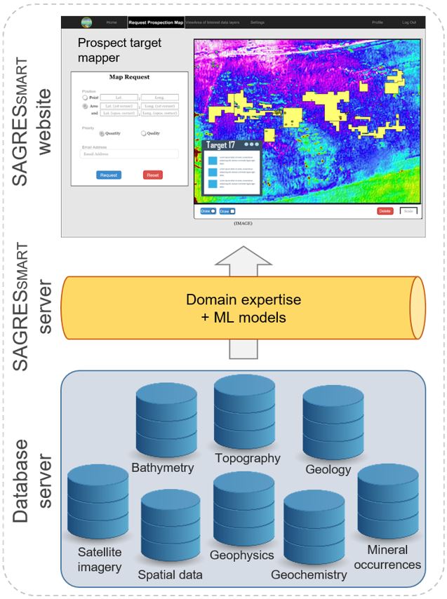
SAGRESSMART is based in a simple concept: Multi data sources, one platform. This new-generation mineral-exploration solution combines multi data sources, including satellite remote sensing data, with artificial intelligence and machine learning to better understand resource potential on a regional and localized scale, making full use of current and historically unutilized data. For seafloor mineral exploration this yields a winning combination of increased chances of success and much lower operational risks and costs.

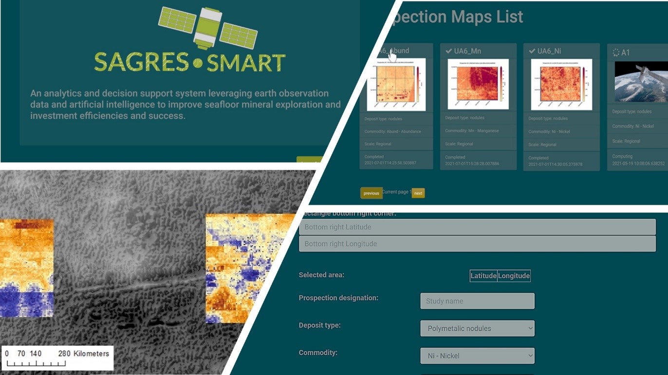
This next-generation analytics and decision-support solution works by automatically gather raw data from many different data sources for a user defined areas of interest. This data is cleaned, transformed, interpreted and then used to train ML in order to predict targets. These are identified with potential levels (low, moderate, high probability) for mineralization and ranked by risked resource potential. The user can then visualize and export the predicted prospectivity map/data together with a results summary report for one selected target or for all targets.
Space Added Value
Combined with known mineral occurrences and other field data, SAGRESSMART uses earth observation to provide improved maps and information for seafloor mineral exploration. Satellite earth observation is a very efficient way to collect vast amounts of data on elements necessary for the occurrence seafloor mineral deposits, particularly in unexplored frontier and remote areas due to the absence of data and difficult access, and to gain environmental and geological understanding in a multivariate space. Of particular interest are observations about the ocean physical and biogeochemical variables. These parameters greatly influence the occurrence, accumulation and quality (grade) of the seafloor mineral deposits both at regional and local scale. As opposed to the exclusive use of data coming from multi-parametric mooring systems or vessel-based surveys, SAGRESSMART takes advantage of the increasing available earth observation data and integrate all relevant data into a unique dataset to explore and quantify the different correlations, trends and relationships between the different variables.
Current Status
We successfully concluded the Pilot Demonstration Phase (PDP). The aim was to assess and validate the proposed service logic and flow, performance, and business fit. The pilot operations was focused on polymetallic nodules resource assessment in the Clarion-Clippertone Zone, a region spanning over 5,000 kilometers across the central Pacific Ocean at depths between 4,000 and 5,000 meters.A total of 7 users participated in it. The Final Review of the Project is scheduled for the 06/09/2022


