Objectives of the service
The goal of the feasibility study is to build up a sustainable service solution that helps to overcome the current difficulties of Search and Rescue missions, that are often unpredictable in their nature and demands lots of communication between involved parties.
It will be studied how a satellite communication solution can be used to ensure operation in remote or damaged areas, in order to enable monitoring and control of the most significant mission parameters, improving response time, and the effectiveness of an intervention.
Similarly, the study will invest how satellite navigation combined with communications and cartography, can allow a complete tracking of personnel and assets, making commanders aware of the position, health status and actions of the personnel along the whole mission.
In addition, thanks to access to health status data, images and significant events of a mission. while tracking personnel and assets, response time and coordination should be improved together with the safety of the involved personnel.
The fact that the starting point for the concept is dual use with a common infrastructure, makes the service suitable to joint and combined operations, and should minimize the costs of infrastructure maintenance.
Users and their needs
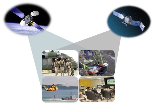
The user groups for the SAPI&NS services are rescue organisations, both civil and military, like:
- Italian Fire Brigades: involved in rescue operations e.g. in case of environmental disasters;
- Italian Coast Guard: involved in rescue operations in case of boat accidents or sea immigration emergencies (the Coast Guard is a corps of the Navy carrying out tasks and functions related to the use of the sea for civilian purposes);
- Italian Mountain Rescue Organization (CNSAS): operating in mountain or remote areas, and strongly specialised in the search phase in case of missing person
Service/ system concept
The added value of SAPI&NS service is that it is based on a co-design activity with potential end users. There are three key feature segments that shall be achieved by the service design:
Integration to give users the possibility to use in a single suite multiple functions:
- Tracking helicopters and personnel
- Images Management
- Healthcare monitoring
- Search area management
- Cartography
Portability to allow the same Hardware and Software to be used by different people or helicopters,
Tailoring to design a custom solution in a common framework, in order to share service costs without losing customer specificity.
Space Added Value
Due to the unpredictability and hostility of most of the Search and Rescue operations, satellite communication link is required to be independent of ground infrastructure, have sufficient coverage and high reliability.
Satellite navigation enables precision positioning of vehicles and personnel, ensuring also accuracy, integrity and continuity.
Current Status
Following the delivery to ESA of all the project documentation, the SAPI&NS Feasibility Study was concluded by the final review held at ESTEC, on 19 June 2015.
The SAPI&NS project led to the definition of a concept based on challenging user needs and requirements, design the associated architecture and it allowed the performance of a preliminary remote terminal test within a helicopter, in May 2015, with the goal to evaluate the telecommunication and navigation signals coverage. While this feasibility study has delivered some positive outcomes, a number of technical (e.g. accurate tracking of helicopters and data transmissions with helicopters) as well as economical (e.g. service profitability) aspects yet require additional investigations before allowing Vitrociset to move towards a demonstration project.