Objectives of the service
The SAT-DEFO service is an independent source of reliable, direct and immediate information about the mining-induced ground deformations. The system informs the users about deformations of the ground surface on their real estates.
The service is aimed at selling ‘information’ accompanied with some ‘knowledge’ which enables further actions to be taken by the users. For example, reports suggest further actions to customers depending on the occurrence and scale of ground deformation, and a map showing subsidence basins helps to locate addresses at risk of mining damage. The service covers time period from 2014 up to the current date. Various features are made available:
-
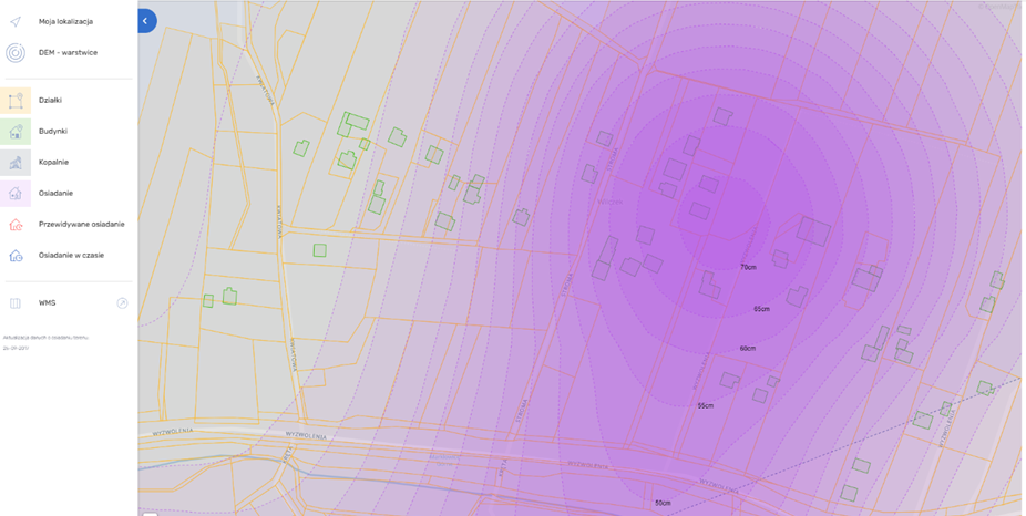
Full map of subsidence, also divided per land plot;
-
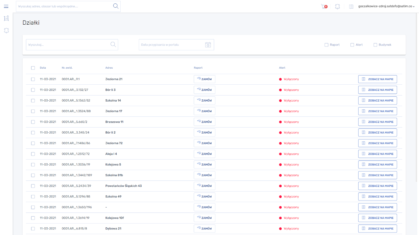
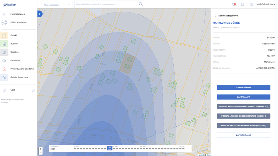
A report on historical ground deformation on a given parcel of land with information on what further action may be taken, e.g. related to the compensation process or securing buildings;
-
Automatic alerts on the current occurrence of subsidence on a particular plot during the service subscription period along with information on the deformation scale;
-
Leads for law firms or restoration companies.
Users and their needs
The key customer segments targeted by the SAT-DEFO service are:
-
User group A citizens of the mining areas
-
User group B: local authorities of the mining areas
-
User group C: law firms and renovation companies
The specific characteristics of the service that respond to the identified customer needs (the value that the product or service offers to its customers) can be summarized as follows:
User group A:
-
Additional documentation that supports citizens' discussions with a mine related to damages
-
Verification of settlement values on property owned by the customer, but also being considered for investment
-
Helping neighbours in the process of compensation takes too much time and attention; they would like to help but maybe decrease their ‘cost’ in it
User group B:
-
Provide citizens with open and free information about subsidence
-
An objective source of information about actual subsidence phenomena, independent of information published by mines
-
An informed urban design policy, with increased attention to the structural requirements of buildings lying within the range of subsidence basins
User group C:
-
Location of clients potentially interested in services
-
A document containing subsidence information that can be used as evidence in a court case
Service/ system concept
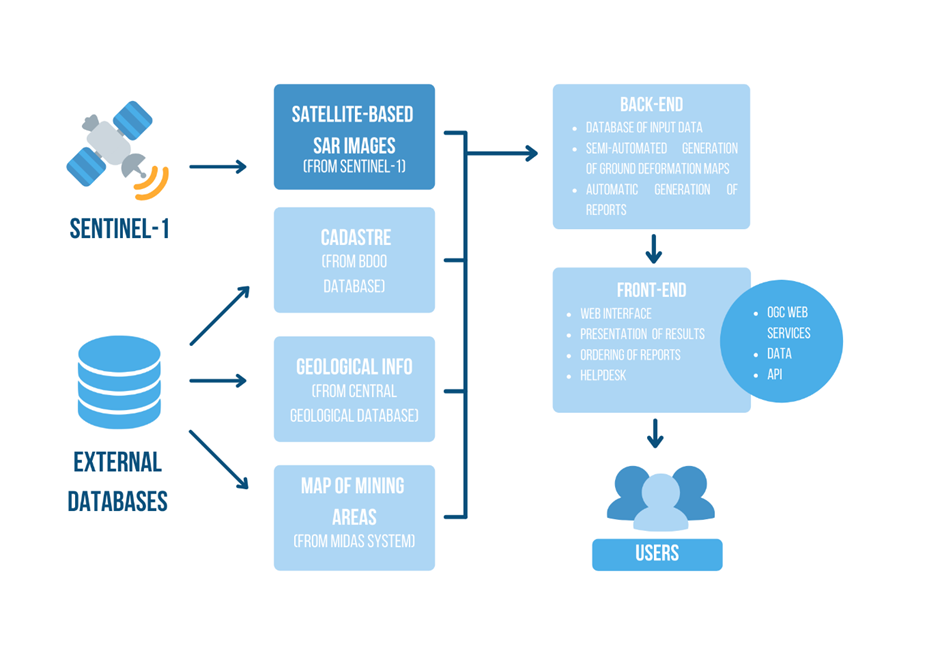
The SAT-DEFO web application provides verified, up-to-date, historical and current information on land deformations caused by mining activities. The service uses SAR satellite images from the Sentinel-1 mission to generate subsidence maps of the analysed regions, and then automatically provides information in the form of reports and alerts to the users. The system consists of the following components:
-
database of input data- important part of the SAT-DEFO service are external data sources (cadastre, building map and maps of mining areas)
-
generating deformation maps - based on Sentinel-1 SAR data, divided into plots
-
automatic generation of reports - a report on historical ground deformation for a particular plot of a specific land plot together with information of which mine could be responsible and what can be the next actions, for example related to compensation process
-
presentation of results, ordering of reports, helpdesk
Space Added Value
The satellite-based Earth Observation asset have been used in the SAT-DEFO service. Specifically, the SAR imagery from Sentinel-1 satellite are used to generate ground subsidence maps based on differential interferometric processing.
The alternative technologies include ground-based solutions like levelling and GPS measurements. They have, however, a number of limitations comparing to satellite-based measurements: they can cover very limited area for a limited time to be cost-effective; they cannot provide information on the past subsidence phenomena; they are relatively expensive. However, they have also some advantages over satellite-based measurements: they may be more accurate; they can cover also incoherent regions (e.g. forests). Having in mind all those advantages and limitations, we strongly believe that the value proposition of SAT-DEFO is very important. And we confirmed this during the Feasibility Study. Of particular importance is the ability to provide information on historical land deformation.
Current Status
In December 2021 the development work on the website was completed and it is now a fully operational solution allowing for commercial sales.
SAT-DEFO is advertised in mining communities through press, commercials and local authorities. The application has gained a multitude of users and received positive feedback, both from individuals and the scientific community.
All services of the website can be fully used through the OsiadanieTerenu.pl website.