
Objectives of the service

Through SAT-SHV companies get access to multi-modal, real-time and end-to-end shipment visibility data of their supply chains to reduce costs and better manage services and processes around it.
Satellite data from maritime vessel via AIS and aircrafts will be integrated and improve data quality and timeliness of traditional supply chain management. Intelligent algorithms and machine learning will in addition identify short-comings and data-inconsistencies and deliver better and faster data points.
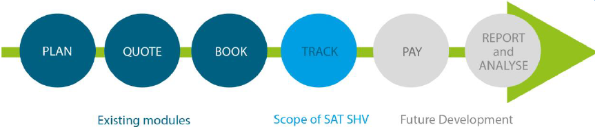
PLS is in a unique position to integrate SAT-SHV data with other PLS modules, such as Global Price Management or Detention & Demurrage to enable additional benefits of using the platform, for example for more complete process coverage in the Quote&Book process or a faster and more accurate calculation of detention and demurrage charges.
Users and their needs
The Shipment Visibility Platform targets all partners of the international supply chain, especially Shippers and Consignees, Logistics Service Providers (LSP) and 3PLs, as well as Air, Ocean and Land Carriers and Terminals. Through SAT-SHV companies get access to multi-modal and end-to-end shipment visibility data of their supply chains to reduce costs and better manage services and processes around it.
Key scenario of any SAT SHV user is to get access to the real time status of a booked shipment, i.e., to find out where the shipment is at the moment in time as well as to see if the shipment is actually travelling as per planned voyage expectations or if there are any exceptions from the plan, e.g., a delay. In case of any exceptions the user shall be notified about the exception to evaluate if any action needs to be taken.
Service/ system concept
PLS plans to develop a complete eForwarding suite of modules to support 3PLs and Forwarding companies digitalizing their service offering. The Quote and Book module will be enhanced with various track & trace features, including Track and Trace of Containers and Shipments, as well as Visibility of Milestones from underlying Ocean Carriers.
The system will be enhanced with SAT AIS real-time visibility of the vessels / the shipment while at sea through SAT AIS data.
Identification of deviations from planned dates as well as data points received from Carriers, e.g. updated and predicted ETA, validation of ATD and ATA, identification of transhipment moves. In addition functionality and modules, such as Reporting, and Payment will follow.
The PLS eForwarding journey
Basic Track and Trace features have been used by shippers and forwarders for years. However, real-time and satellite supported data and predictive insights have only become available with the emergence of transportation visibility technologies.
The PLS technology enables a more automated and real-time flow of data. Real-time and SAT supported visibility solutions focus on establishing strong connections to a large network of carriers, Satellite data providers and leveraging machine learning based on available data, ensuring stakeholders can access real-time insights in an actionable format.
Space Added Value
The SAT SHV platform plans to integrate SatNav services for ocean vessels and at later stage also for aircraft.
In the maritime area Space-based AIS (SAT-AIS) makes it possible to track seagoing container vessels beyond coastal areas that are equipped with mandatory AIS tracking devices. The position of the container vessel will be mapped to specific events, which than will update the tracking object. Key events that can be monitored via SAT AIS are estimated time of arrival (ETA), actual vessel departure (ATD), transits stops, vessel arrival (ATA). In addition, delays during the voyage can be identified and trigger updated ETAs.
In a second step the same concept will be applied for airfreight, e.g. using Aireon’s ADS-B. ADS-B is an air traffic surveillance technology that relies on aircraft broadcasting their identity, a precise Global Positioning System (GPS) position and other information derived from on-board systems. The data is broadcast every half a second from the aircraft and is being used by Air Traffic Controllers (ATCs) to identify and separate aircraft in real time. Space-based ADS-B extends the same ADS-B technology currently received on ground-based receivers to space.
Current Status
The application will cover two main business processes:
- Generation of shipments (tracking object), including a standard set of planned milestones and events. The tracking object includes all attributes of supply chains, including mode of transport, routing, number of legs, movement types, planned events, etc.). In addition, a customer view and a carrier view can be distinguished.
- New event creation for a tracking object, to map actual events against the plan and identify deviations and exceptions.
Actual events will be integrated from the logistics partners into the application via web-services, EDI/IFTSTA or similar technologies (e.g. ANSI 315/215). For ocean and air mainleg an additional SatNav integration is foreseen.
Supporting modules of the application will be available for user management, master data and configuration.
Mock-ups and initial visualisations have been developed in the area of the “Quote and Book” module as well as for the “Detention and Demurrage” application.

The mock-up environment for the Detention & Demurrage module is designed as a natural extension of the already existing tariff module for D&D. The new D&D portal with SAT SHV data included is illustrated in the following few portal screen, which is also available in a more complete MVP environment.

The system would give the option to drill-down into a specific region. Locations highlighted are called “hot-spots” and are to avoid the map only be highlighted with “bubbles”, while the customer can define the hot-spots themselves. In addition, rules can be made to show “non hot-spot” locations that have D&D costs above a certain amount. A user can drill down all the way to a port and terminal level if required.
The Kick Start Final Review took place on 26 April 2021 and a Demonstration Project is under consideration.