Objectives of the service
The SatMRV service is intended to provide scalable and cost-effective Soil Organic Carbon (SOC) sampling plans and maps for Soil Carbon MRV (monitoring, reporting, and verification) applications. The SatMRV service reduces the cost and heavy field effort associated with SOC sampling and monitoring by leveraging remote sensing and machine learning, while also supporting sustainable and regenerative agriculture. Our objective is to empower stakeholders with the tools they need to support transforming agriculture from CO2 producer to CO2 sink.
Users and their needs
SatMRV offers satellite-based soil organic carbon (SOC) mapping and monitoring solutions to a wide range of stakeholders in the agricultural and food sectors. Our primary clients include Carbon Farming (CF) project developers, farmer, food, and agribusiness companies, particularly in countries with advanced agricultural systems and strong environmental policies, such as North and South America, Australia, and Europe.
Soil carbon projects developers on the SatMRV service for high-resolution, verifiable SOC data when designing, monitoring, and certifying carbon projects in accordance with international standards. Our platform provides the tools required for effective MRV (Monitoring, Reporting, and Verification), which allows for the creation of high-quality, protocol-compliant carbon credits. This provides a solid foundation for confidently accessing climate finance and participating in carbon markets.
Farmers gain access to clear, understandable information about their soil's carbon performance and overall health. Our solution enables them to track progress towards regenerative practices and participate in carbon programs. Farmers who increase soil carbon improve productivity and resilience while also gaining access to additional income streams through carbon credit generation.
Food brands and agribusiness companies use SatMRV to gain visibility into Scope 3 emissions from sourced commodities as well as to assess the climate impact of their supply chains. With accurate, up-to-date SOC data, these companies can help their suppliers transition to regenerative agriculture, reduce emissions across their value chain, and communicate their sustainability progress to customers and stakeholders.
User Needs:
-
Accurate and up-to-date SOC measurements to track and reduce emissions across agricultural supply chains.
-
High-quality SOC data at minimal labour and cost to support scalable, sustainable sourcing initiatives.
-
A user-friendly, cloud-based platform to manage carbon projects efficiently across large geographic areas.
-
A robust method for generating certified carbon credits, aligned with major carbon standards and protocols.
The SatMRV service enables all stakeholders—developers, growers, and food companies—to take measurable climate action in the soil. Supporting the transition to regenerative agriculture strengthens supply chains and enables businesses to lead with integrity in a low-carbon future.
Service/ system concept
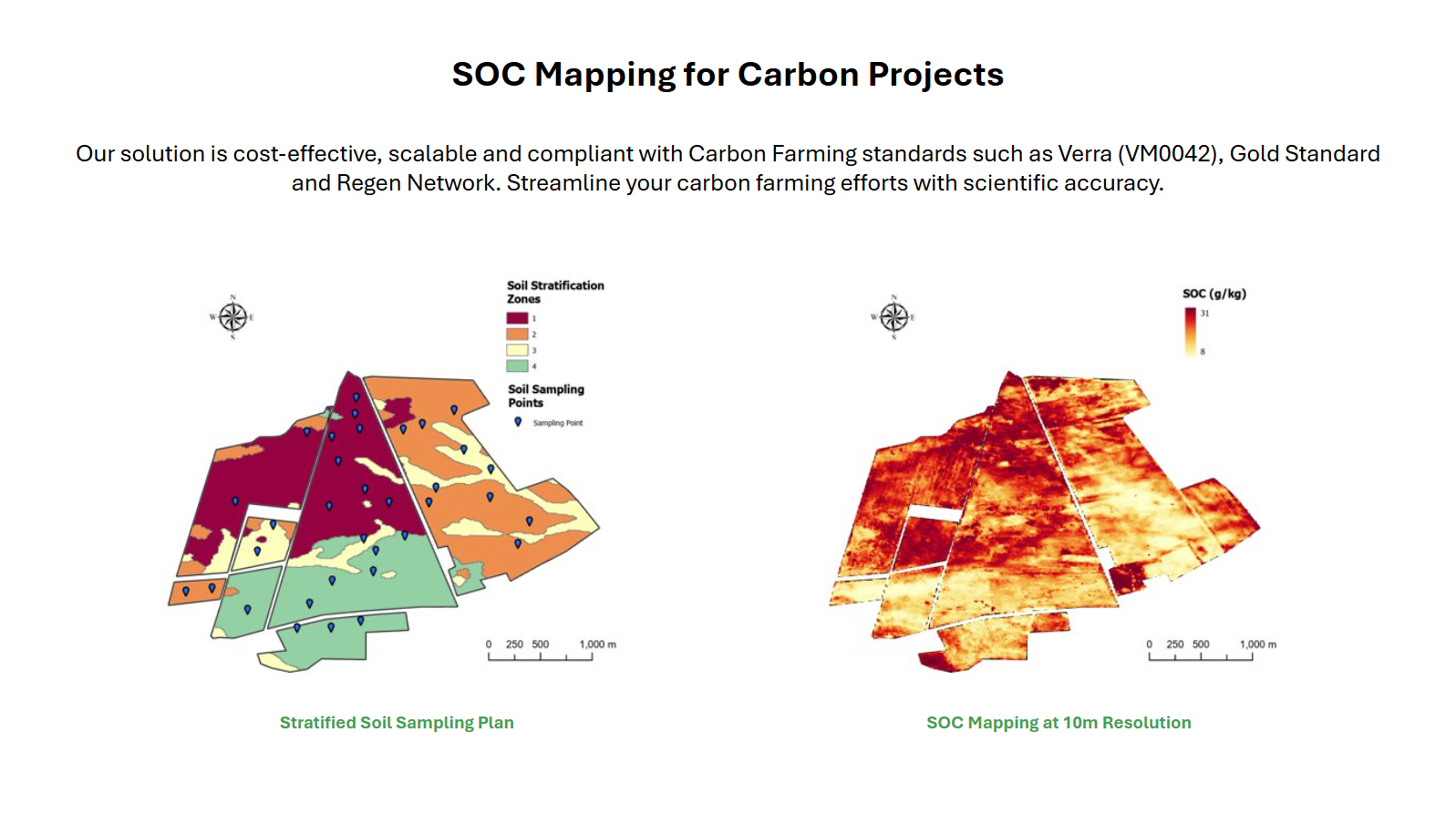
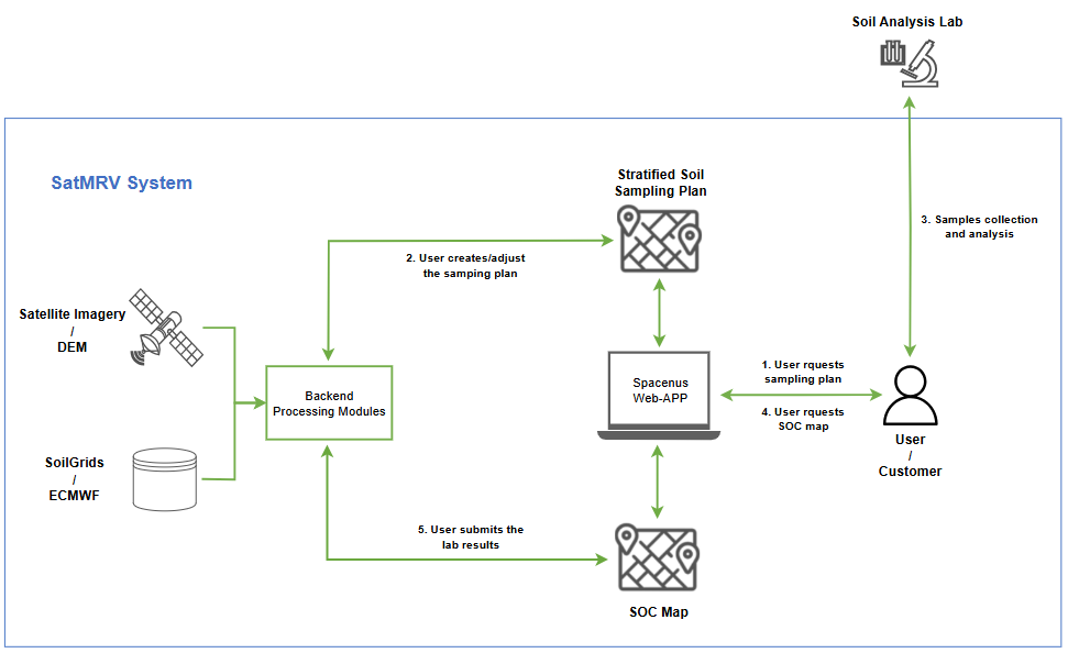
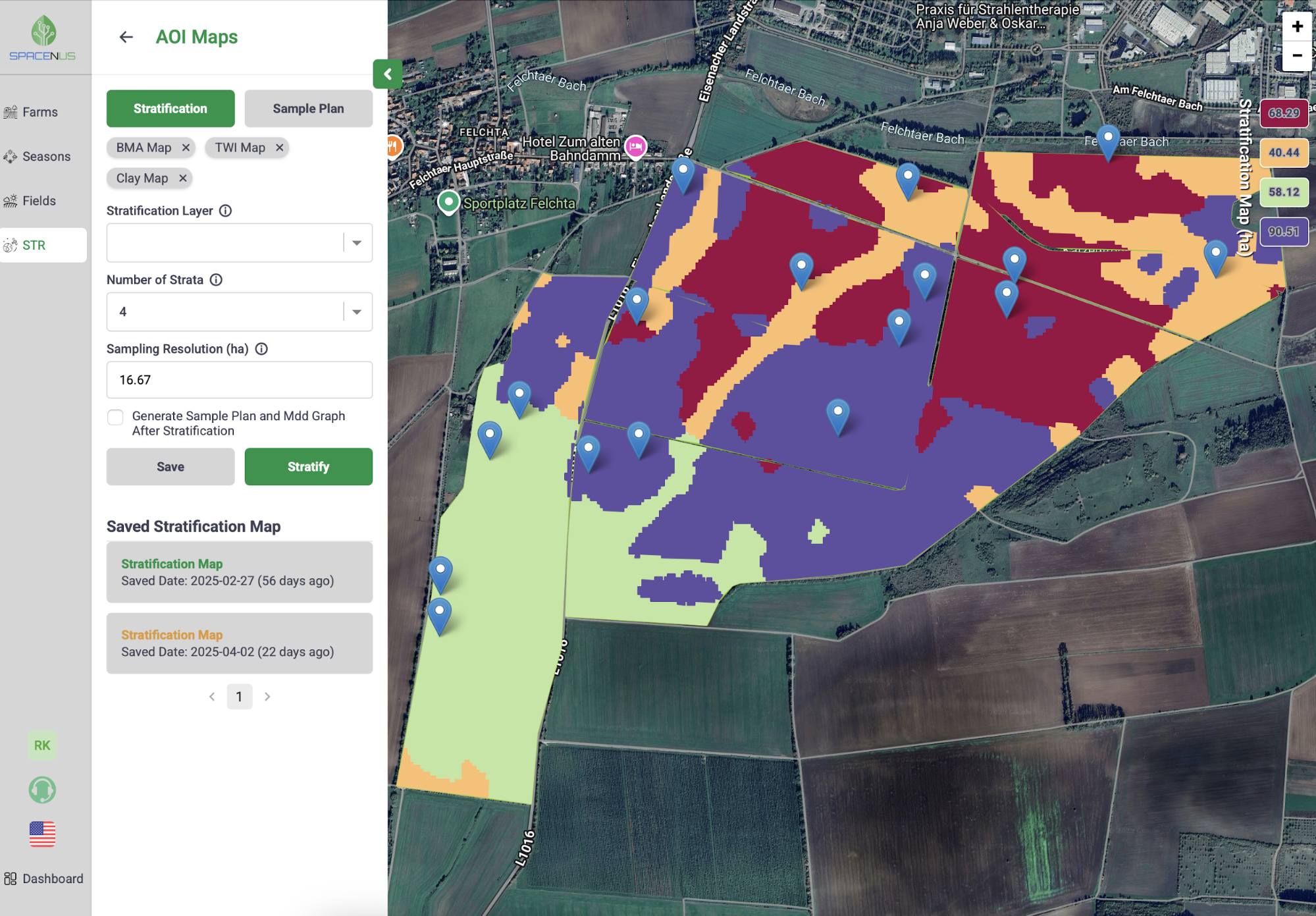
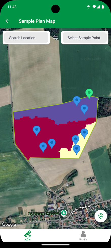
The SatMRV service is delivered to end-users via Web-app and API, allowing them to easily delineate or upload their AOIs, request stratified soil sampling plan for an AOI and customize it based on their requirements and/or knowledge of the AOI, and finally map SOC for the AOI. A key feature of the SatMRV service is its advanced stratified soil sampling planning tool. It allows the users to optimize the number of samples by doing a sensitivity analysis for the Minimum Detectable Difference (MDD) of the sampling plan. Furthermore, end-users can use a mobile app to accurately navigate to the sampling locations.
Space Added Value
The SatMRV service is powered primarily by Earth Observation (EO) satellites (Sentinel-2, Sentinel-1, and Landsat-8/9) as well as a variety of Land/Environmental variables (such as elevation, topographic wetness, soil texture, weather variables, etc.) derived from high resolution Digital Elevation Models, Soil Databases, and Weather/Climate Models. The combination of all of the previous elements ensures the accuracy and reliability of the soil sampling plans and SOC maps, as well as meeting the requirements of CF Standards, which allow for the issuance and certification of carbon credits.
Current Status
Spacenus has successfully completed the demonstration project of the SatMRV service and has moved forward with its commercialization and rollout in Germany.

Prime Contractor(s)