Objectives of the service

SatNetMonitor increases efficiency in network maintenance and improves the reliability of electricity networks. Cloud based SatNetMonitor gives the network owners a new way of securing the network operation, speeding up troubleshooting, anticipating maintenance needs, preventing incidents, and detecting additional structures in and around the network. In extreme situations like storms, the system enables to see fast the immediate changes in the vegetation close to the network. Based on an Artificial Intelligence (AI) and automated workflow, the user has better situational awareness and tools to identify and fix network problems that could otherwise be completely undetected, found occasionally in extreme storms or with expensive and time-consuming field inspections.
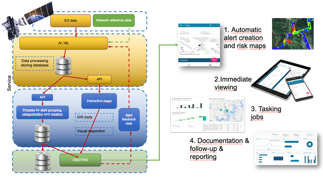
SatNetMonitor is system that covers the whole process from data collection to network vegetation and risk identification to risk preventive actions and management of field work resources.
Users and their needs
Users of SatnetMonitor are European electricity Transmission Operators (TSO) and Distribution Service Operators (DSO) who will use the service to locate possible fault spots in their networks and to manage preventive maintenance tasks to the network to increase network resilience. Nine European TSOs and five Finnish DSOs participate in this project. Their most important goals are:
- Happier end-customers by decreasing the number of network failures and shortening interruptions.
- Improve the reliability and quality of the whole network.
- Decrease the risk of a network failure.
- Automatically identify and update risks caused by vegetation close to the network.
- Decrease the cost of preventive maintenance by focusing work to the high risk spots.
- Detecting human-made objects in and close to network causing risks to network and other parties.
- Easy to setup and use. No complex training or installations are needed.
Service/ system concept
SatNetMonitor uses multi-data satellite data-sources for optimizing cost and efficiency of the service. By analysing and visualizing satellite data SatNetMonitor provides easy-to-use interface with different layering of the data that users can use for decision making..
For the end-users it is not enough just to see the results i.e., technical data and images but it is crucial that the user can make actionable decisions in the same platform. SatNetMonitor gives network companies powerful tool to make work orders, monitor the status of tasks, invoicing and documentation of work done.
Field work resources need to have access to map and satellite images and the actual work orders. That access can easily be provided through SatNetMonitor. In that way network owner does not need to open their all map and network data for third parties.

Space Added Value
SatNetMonitor uses combination of multi-source data combined with open source and commercial satellite data. SatNetMonitor benefits from the continuously declining costs of satellite data, increasing resolution of the data, as well as the emergence of satellite-based SAR imaging which allows imaging also during the night and in bad visibility. With SatNetMonitor the same area can be monitored daily, weekly, or monthly and all potentially risky changes on the ground are automatically identified immediately. Annual inspections done to the network on the ground and LIDAR are not nearly as cost effective or fast in detecting new risks. SatNetMonitor is more agile and more cost-effective solution to network inspections than the traditional methods. If needed the inspection cycle of the network can easily be lengthened with SatnetMonitor whereas the earth-bound systems are limited by physical resources and the size of the network.
Current Status
The services and the system have been successfully tested with customers. Use cases have been further developed and business cases validated. The system algorithms and user interface have been adapted to the use and business cases.
The services are being rolled out commercially by the consortium.


