Objectives of the service
Satellite technologies are one of the Game Changer innovations on the roadmap agreed by railways stakeholders in the ERTMS MoU signed on September 2016. Benefits of Satellite applications are a reduction of the ERTMS ownership costs that in turns means a lesser reliance on dedicated railways infrastructures, such as fixed balises and GSM-R telecom network that today are part of the ERTMS solution. The challenge is a seamless adoption of satellite applications without impacting on the highest safety levels guaranteed by ERTMS and recognized world-wide thanks to a coordinated and standardized certification process. Satellite positioning and multi-bearer satcom services are the innovative breakthroughs to be incorporated on a full-scale ERTMS L2 baseline 3. The new satellite navigation and telecom service demonstrators are the front-runner of cost-effective operational services for the ERTMS platform and able to contribute to the modernization of the local and regional lines.
Users and their needs
The targeted users are Railways Infrastructure Managers and Railways Undertakers worldwide which will be selecting the ERTMS standard.
The deployment of the ERTMS is a commitment in Europe for international TEN-T corridors, mainly for interoperability across the countries, but also because ERTMS present other advantages like increased capacity, higher speeds, higher reliability, etc.
Infrastructure Managers are planning huge investments to modernize local and regional lines based on old technologies. To renew low traffic lines the implementation of ERTMS is also requested (considering EU countries plan to dismiss national signalling systems), but ERTMS related costs are now still too high. Adoption of Satellite Based ERTMS system and Satellite telecommunications is the answer. These systems will allow to reduce both implementation costs (high reduction if GSM-R will be eliminated) and operation and maintenance costs.
ERTMS is also widely exported abroad EU, like in Africa, Asia, Middle East, Latin America and Australia, becoming a de-facto world standard representing about 50% of the export for the European industries.
Service/ system concept
The application consists of an ERTMS system by using satellite navigation with proper localization device systems and IP-based public telecom (including SATCOM) services instead of the GSM-R. These functionalities are enabled by “services” that are external to the ERTMS, reducing the need to build dedicated infrastructures. This technology presents advantages in terms of cost reduction in CAPEX and OPEX for the implementation of ERTMS.
The applicability context is represented by the RFI Pilot Line Novara-Rho, which has been selected by RFI and Hitachi Rail STS for being the first application of an ERTMS Level 2 system based on GNSS localization.
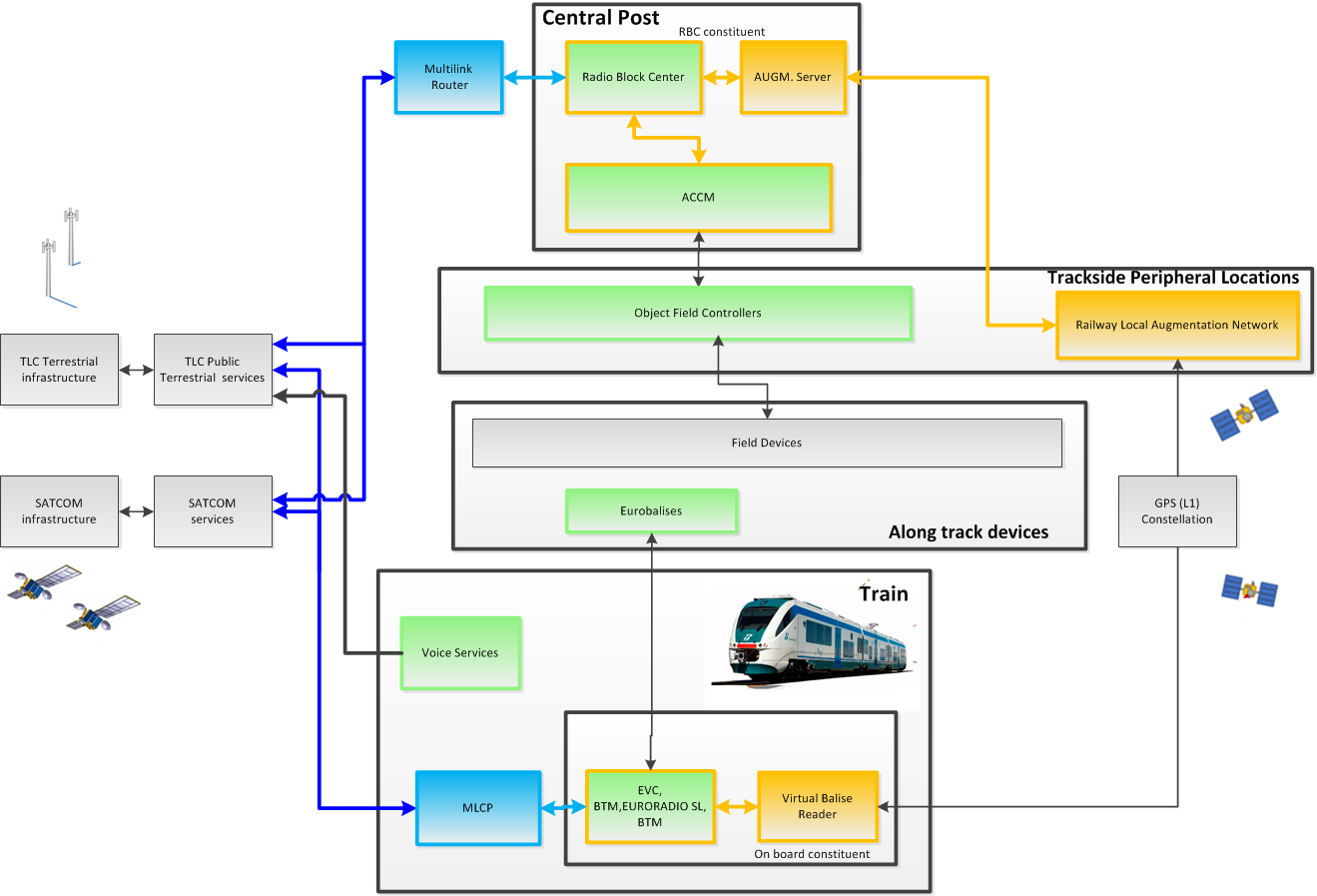
The high-level reference architecture adopted for the demonstrator represents functional modules in charge of implementing the GNSS train positioning (orange elements) and the IP-based multi-bearer RBC/EVC data exchange (blue elements).

Space Added Value
The objective of a satellite-based ERTMS system is to reduce the total cost of ownership of the system to the Infrastructure Manager to be economically sustainable for the local and regional lines, also improving the lines capacity by reducing trains headway. Capital expenditure costs are reduced thanks to the satellite-based ERTMS solution based on satellite navigation and on public telecom network including satcom, due to saving in procuring and installing physical balises and in equipping dedicated GSM-R infrastructure. Cost reductions will be achieved on the operational and maintenance of the whole ERTMS system in operation.
Current Status
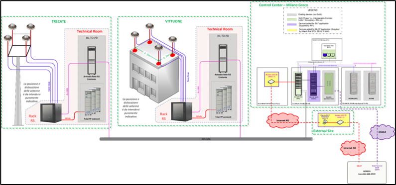
Novara-Rho conventional line has been equipped with an ERTMS-L2 system superimposed on the existing Italian national system. The pilot line Novara-Rho interfaces a centralized computer based IXL placed in Milano Greco central post.

The system has been tested using both TLC configurations:
-
standard GSM-R service : ~2000 kms
-
Multi-Link Communication Platform : ~400 kms
The analysis of data collected during train runs demonstrated that:
-
the system always provided a safe position
-
accuracy was in general very high:
-
Position: mean error ~10 cm
-
Speed: mean error ~-0.03 km/h
These positive project results have been obtained also thanks to dedicated tools designed and developed for:
-
simulating effects of local environment on GNSS signals (i.e. multipath and RFI) during lab tests
-
assessing GNSS signal quality along the line to define the specific GNSS based application
-
measuring performance of the full GNSS-based system by analysing measurements and data collected during real or simulated train runs.


